I know this is about 10 days later than I usually kick these out – apologies! While I’ve had a general idea about what the forecast will hold, putting these together does tend to take a bit of time and – man, oh man! – have I been short o time, lately.
The usual preamble: I understand that everyone has a Winter Outlook. Particularly these days. The usual suspects are still there. The Farmer’s Almanac, The Weather Channel, The Climate Prediction Center at NOAA. But you’ve probably also see Winter Outlooks from “Bob’s Weather Page!” on facebook or “Extreme Tornado Storm Chasers Weather Blog dot Extreme Weather dot Always Hyping dot com.”
I can’t speak for them. What I can do, though, is walk you through the steps I take in order to put together a seasonal outlook and why I think certain things are more likely or less likely than any other given year and how this Winter may shake out along the Gulf Coast.
You may be thinking, “I live along the Gulf Coast, does this mean me?” It might. And it might not. This outlook is mainly for most of Louisiana, most of Mississippi and most of Alabama. As well as parts of Arkansas, Georgia and the Florida panhandle.
LAST YEAR
I always like to start these off with a look back at last year. This is a good way for me to be transparent and show you that I am far from perfect with these forecasts. I try, but seasonal forecasting is tough.
Last year, this was the forecast….


And, below, is a national map of the actual temperature and precipitation departures from normal. We were not quite warm enough with temperatures and it was quite a bit drier than anticipated last winter, too.

Given that this year is another La Nina, it is probably safe to go with a similar forecast, but I think there are some places that we can apply some of the things we have learned to make the forecast a bit better.
THIS WINTER
Given last year, and previous La Ninas, I tend to think that this year will be warmer than average and drier than average. That shouldn’t be very surprising. That is how things shake out in a typical La Nina.

However, the Tonga Eruption earlier this year threw a stick into out proverbial bike spokes. Because that blasted a lot of water vapor into the upper atmosphere, there will be a higher-than-normal likelihood of very roller coaster-like weather.
So even if we finish a month “warmer than average” there may be one or two shots of some pretty cold air that sink pretty far south. And I don’t mean “hey, its pretty chilly!” I mean, “Hey, I wish it would precipitate because if so, it would be snow!”
So, take the “warmer” forecast above with that asterisk.
SOME EXTRA EXPLANATION
Starting with the La Nina Winters of 2000-2001, 2005-2006, 2007-2008, 2008-2009, 2010-2011, 2011-2012, 2016-2017, 2017-2018, 2020-2021, 2021-2022, we use these years as a foundation.
All of these years came back warmer than normal.
And they were also warmer than normal leading into Winter. Looking at the October to December data for those years, you end up warmer and drier across much of the US – and in particular across the central Gulf Coast.

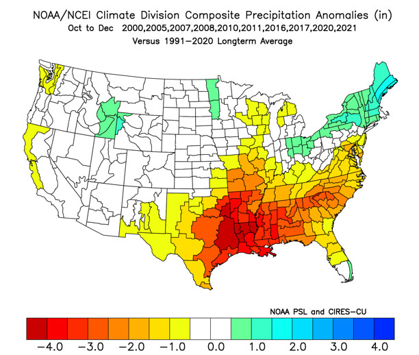
So, if you’re looking for rain to help your dried up yard, generally speaking there won’t be as much as normal.
That is also a good indicator that any cold during these years would be backloaded into Winter, too. That means the rest of October, November and December will be warmer than normal with only a few shots of “probably not that crazy cold” cold. Then the colder stuff would show up in January and February.
And you might be thinking, “hey wait a minute! We just had one of the earliest freezes on record! Doesn’t that count!”
It does! But I don’t think 32F counts as “crazy” cold. I mean overnight lows in the teens and 20s. With highs around 40F. That, to me, for the Gulf Coast, is “crazy cold.”
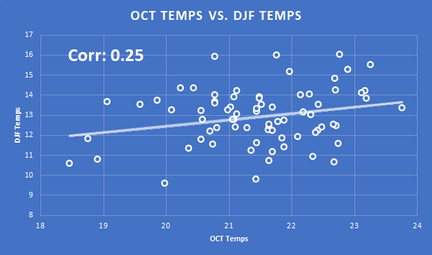
It is also worth noting that a warm October or cold October has very little bearing on what Winter will hold. Looking at the record books, the correlation between October temperatures and Winter temperatures is a meager 0.25 out of 1.
So this early cold shot isn’t a good indicator of anything.
But all is not lost, cold lovers! I think we get a few shots of that this Winter. So, now is probably the time to make sure your pipes are insulated. Easier to do it now (when all the insulation at the hardware store is cheap) than later.
That is the other reason I think a warmer November and December are no real indicator about how cold we will or won’t be in January and February.
Looking at those same years in January and February, it produces a drastically different temperature map.

In fact, those same years mentioned above, those January and Februarys feature – on average – about 12 days where the average daily temperatures struggles to pass 40F. That means, often, overnight lows below freezing and afternoon highs below 55F.
And those same years feature five days per year where the average temperature for the day barely cracks the freezing mark. And two days each year where the average temperature doesn’t crack 25F! Really cold stuff.
THE BOTTOM LINE
Generally, this Winter looks to be warmer and drier than normal.
The forecast this year is complicated by the Tonga eruption which ejected a lot – like hundreds of thousands of tons – of water vapor into the upper atmosphere. This could have a bit of an exaggerating effect on the weather patterns. Very warm turning to very cold.
SEVERE WEATHER
That “very warm” to “very cold” could mean an increased potential for severe weather. That is typical during a La Nina winter, particularly the back half as we move from January through March. But in years past, this has cropped up in December, too.
COLD WEATHER
On the flip side of that warmth, analog years suggest this winter will feature about a dozen days with below freezing (keep in mind since this is an average number of nights, it means more below-freezing nights to the north and fewer below-freezing nights to the south) overnight temperatures. And a decent chance that a few days where temperatures struggle to get above freezing at all.
SNOW & ICE
For those wondering about snow given the drier-than normal forecast…. I think we see some snow and/or ice. La Nina winters are famous for creating snow across the region. I don’t see any reason to argue with history. Yes, even in “warmer” and “drier” winters, there is snow.
And, in fact, given the chance for more topsy-turvy temperature swings, I would argue that snow and ice are even more likely this year than years past. Whether is sticks to anything, anywhere… how much you see in your backyard… and other questions I’m sure you have are unanswerable at this distance in time. But – very generally – I think the odds are in everyone’s favor.


That was interesting. Thanks for all the hard work you do.
Looks like, as usual, you put a LOT of work into this and it is VERY much appreciated! This is just another example of why you are SO very much missed.
Looks like, as usual, you put a LOT of work into this and is very informative and extensive. This is just another example of why you are SO badly missed! If only we got this kind of coverage just with the everyday weather … along with much needed accuracy.