Looking at the latest model guidance and a few things we talked about earlier this week seem to be holding the severe weather threat in South Mississippi – somewhat -in check.
While the area is still looking at the threat for heavy rain, frequent lightning, damaging wind, hail and the possibility of a tornado… that threat is a bit lower now than it was 24 hour ago.
From the Storm Prediction Center
The SPC has the area under a Slight Risk for severe weather. That is a two out of five on the one-to-five scale, where five is the most severe.
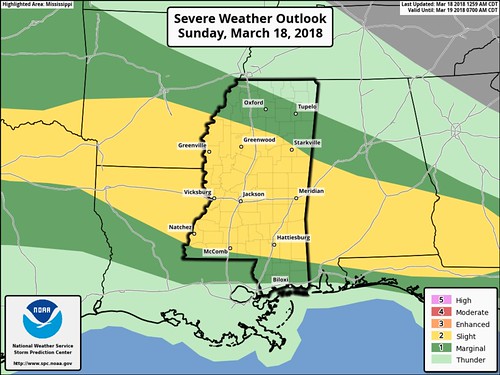
The main concerns from the SPC are for heavy rain, damaging wind and hail. The SPC suggests the tornado threat is under two percent.
A compact shortwave trough rounding the base of the western U.S. longwave trough by the start of Day 1 will progress east today reaching the southern High Plains by 00Z, with a closed cyclone forming within this trough as it moves through OK and southern KS tonight. As this trough deepens, an accompanying 500-mb westerly jet will strengthen to 100+ kt across NM late this afternoon, and then through the Red River Valley into AR this evening through early Monday. Meanwhile, in the southern stream, a lead midlevel impulse will track through the lower Mississippi Valley to the Southeast States today, while a better defined upstream trough moves into the southern Plains to the Ozark Plateau this afternoon and evening.
At the surface, a cold front, attendant to a midlevel trough moving off the Mid-Atlantic Coast this morning, will advance south into southern GA and central or southern AL by this afternoon. The trailing portion of this front should remain generally stationary from central MS to North TX, where a triple point should be located by this afternoon across north-central TX (near or west of the DFW Metroplex). Meanwhile, strong height falls spreading into the central and southern High Plains, with the approach of the progressive Southwest States trough, will result in a deepening low across eastern CO this afternoon and equatorward-extending lee trough. This low is expected to track into OK late tonight with a warm front advancing north through eastern OK into northern portions of the central Gulf Coast States.
…Lower Mississippi Valley/Central Gulf Coast and Southeast States…
Thunderstorm development will be possible across the lower Mississippi Valley through southern parts of MS/AL into southern GA as the environment destabilizes. Effective bulk shear will be sufficient for organized storms, with clusters of storms possibly focused along the track of weak midlevel impulse shifting east from the lower Mississippi Valley this morning. Strong wind gusts should be the main severe threat, given weak midlevel lapse rates tending to temper the hail threat.
The Big Helper
Multiple models suggest th development of showers and storms along the Gulf Coast early Sunday morning – between 6am and 12pm – that will cut off the northward flow of warm, moist Gulf of Mexico air. This should choke off the “food” for any storms trying to develop in the afternoon across parts of South Mississippi.

Does that mean there will be zero storms? No.
Does that put a limit on how strong storms will get? Yes.
While this can’t guarantee zero storms, and it can’t guarantee no severe storms, it does mean that the chances that storms turn severe, get rooted and develop a tornado is much lower.
That is good news.
Plus, as the storms move through, they will be a fair distance from the area of low pressure. That distance will limit the amount of mid- and upper-level energy accessible to the storms.
That is also good news.
The Not as Good News
There is still a chance storms develop behind all of the riff-raff earlier in the day. Those storms would be very isolated, though.
The Bottom Line
There will be storms earlier on Sunday for our southern counties – between 6am and 11am. These storms will be on the strong side, but few – if any – will be severe.
The area will have storms also from 11am through 6pm, these storms may be severe with heavy rain, frequent lightning, damaging wind, and hail. The tornado threat looks pretty limited, but it isn’t zero.
After 6pm, the threat really eases back. But it isn’t zero. rogue/renegade storms may still develop, but the likelihood is pretty small. If a storm does develop it will have the potential to turn severe. And at that point we may have to watch for an increased tornado risk based on lingering outflow boundaries from earlier storms.


