Sections of the Southeast face severe weather threat March 18th and 19th
Author: Nick Lilja
|| Published: 3/16/2018 at 12:44pm
There will be another round of severe weather possible Monday for Texas, Oklahoma, Arkansas, Louisiana, Mississippi and Alabama. Storms may develop as early as Sunday afternoon for some before another round develops Monday afternoon, too. That means that there may be two rounds of storms for some areas.
As an aside, this discussion is for all of the above-mentioned areas. Where certain specifics are available now, it will highlighted as to what area is being talked about.
From the Big Wigs
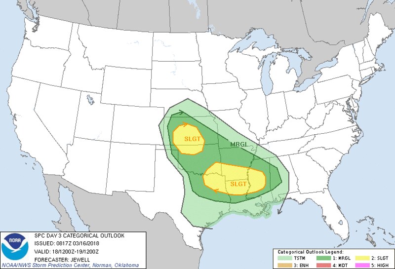
The Storm Prediction Center is already ID’ing an area for possible severe weather. Monday there is already a Slight Risk outlined for sections of Texas, Oklahoma, Arkansas, Louisiana and Mississippi. Keep in Mind that the SPC prefers to “ramp up” threats. So while it may be a Slight Risk today, it might be an Enhanced Risk tomorrow.
Here is the latest discussion from the meteorologists at the SPC:
…SUMMARY…
Scattered severe storms are possible Sunday from northeast Texas across the lower Mississippi Valley, with damaging wind and hail the main threats. A few severe storms capable of hail or wind are also possible from central Kansas into northern Oklahoma.
SPC Severe Weather Risk Map // Courtesy: spc.noaa.gov
…Synopsis…
A potent shortwave trough and developing upper low will move across the Four Corners states and into the central and southern High Plains during the day, with rapid cooling aloft norther of a 100 kt midlevel jet stream nosing into the Red River Valley. Preceding this wave, a lower-amplitude wave will move across TX during day and into the lower MS Valley by evening.
At the surface, low pressure will deepen over eastern CO during the day, becoming vertically stacked with the upper low Sunday night across northern OK. A warm front will stretch from near the Red River across southern AR and into northern MS and AL, moving very little northward during the day. Mid to upper 60s F dewpoints will exist south of this front, while 50s F dewpoints spread northwestward across OK and into KS ahead of the deepening low.
…Northeast TX into MS…
A few storms may be ongoing across northeast TX into the Arklatex region Sunday morning, in association with warm advection near the warm front. Marginally severe hail is possible. This activity may then shift into AR during the day, possibly rejuvenation of serving to focus additional development with further wind/hail threat. Other activity is possible during the afternoon across northeast TX ahead of a dryline and near any residual outflows, perhaps a few supercells as winds will veer with height. Evening activity may track along the warm front into MS, with damaging wind threat. Predictability is low for these areas given variable model solutions and broad region of possible storms along the warm front.
What may change
Based on the latest model guidance, the trend of the most recent guidance going back 36 hours, as well as the CIPS Analogs and the CFS Severe Weather Dashboard, it is likely that the threat for severe weather on Monday will increase during the next 48 hours.
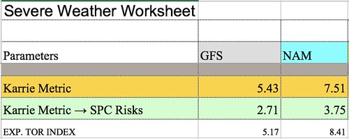
A preview of the Karrie Meter numbers for South Mississippi
It is still too far out for specifics, but in general a “Slight Risk” may not be adequate given the atmospheric setup.
The Good News
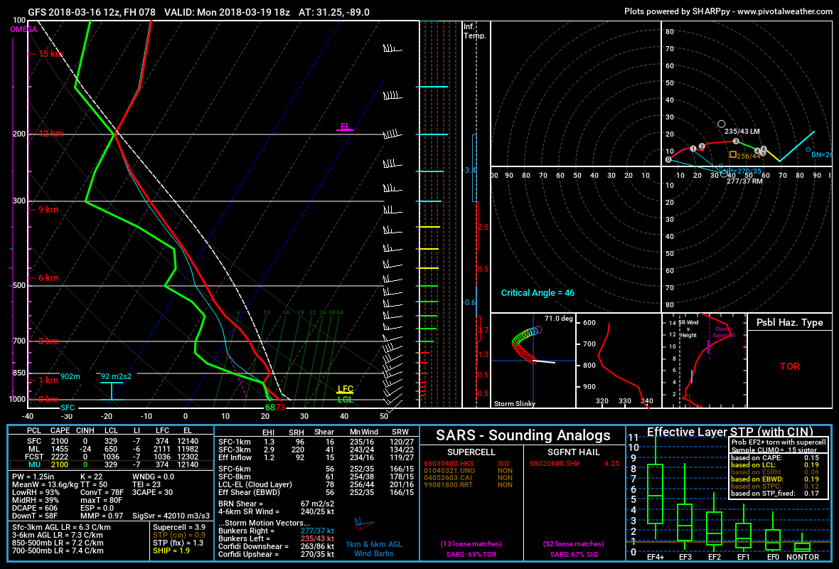
Forecast sounding for South Mississippi on Monday afternoon // Courtesy: Pivotal Weather
1. A cap might save us a lot of trouble: While the region may have plenty of instability, shear and other parameters that go into creating severe storms, there may be one small things that holds storms in check – a slight cap of warm air.
The cap would mean isolated severe storms would still be possible, but because it would put a ‘lid’ on the atmosphere around 3,000 feet up, it may save the area from dealing with widespread severe weather.
2. Storms may not develop:Leading from the previous bit of good news, the shorter-range modeling shows the parameters as sufficient for severe weather, but no storms developing. So while the atmosphere may be capable of producing and sustaining severe weather, we may not have enough ‘umph’ to get it off the ground.
You can think of it as having a big pile of wood, a can of gas and a lighter. All of those things laid on top of each other won’t do anything, until something comes along with some ‘umph’ (someone lightning the gas, perhaps).
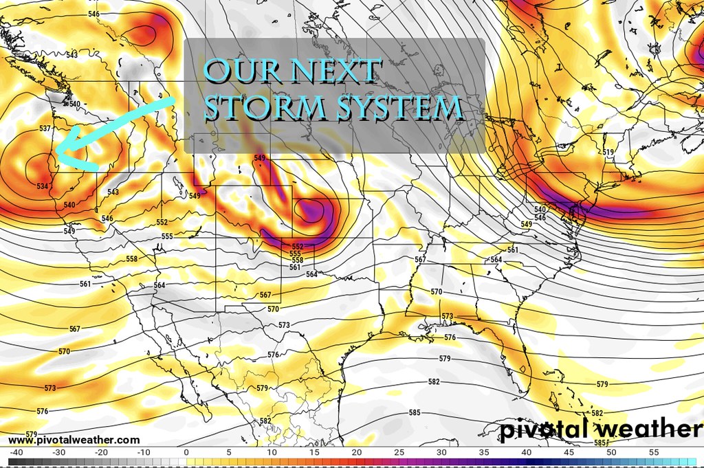
3. The system in question is still a ways away: The system that will bring the chances for storms is just now coming ashore in the Pacific Northwest. As weather balloons sent out by local National Weather Service offices continue to sample the air within and around the system, we will get a better idea of what it looks like. And then that data will be fed into the computer weather models.
Once the computer weather models get a hold of more – and better – data, the forecast will change. And it may change for the better. The last handful of storm systems that have looked ominous at three to four days out, have all ended up being weaker than originally anticipated.
The Bad News
The storm system in question is just coming ashore // Courtesy: Pivotal Weather
1. Specifics are hard to come by: The specific track it takes as it moves toward the area will dictate a lot of what is experienced on Sunday / Monday. The farther north, the less severe weather. The farther south, the more likely severe weather is only for certain areas. We just can’t know certain things yet – like if it will or won’t be worse in your town or your neighborhood. Meteorologists can’t truly get specifics like that until 24 hours out. The math and science just aren’t good enough, yet.
2. The data suggests the severe weather threat is more likely to increase than decrease: The CIPS Analogs shows that – historically – a similar atmospheric setup produces widespread severe weather about 25-percent of the time. In fact, four of the Top 15 most similar atmospheric setups produced between 10 and 20 tornadoes each time. And three of those four times produced at least one long-track tornado. That is why a “Slight Risk” may not be a high enough risk from the SPC.
3. Timing may include overnight hours: Storms may be moving through certain areas during the overnight hours Sunday. And then again on Monday. Please have a plan and a way to get alerted while you are sleeping.
The Bottom Line
The threat for severe weather is increasing Sunday and Monday for The South. If you live in Texas, Oklahoma, Arkansas, Louisiana, Mississippi and Alabama, please keep an eye on the forecast. We will try to post updates as frequently as necessitated by new data. If, between now and Sunday morning, there isn’t a new post here for a few hours, it is because things likely haven’t changed enough to warrant a new update.
Author of the article:
Nick Lilja
Nick is former television meteorologist with stints in Amarillo and Hattiesburg. During his time in Hattiesburg, he was also an adjunct professor at the University of Southern Mississippi. He is a graduate of both Oregon State and Syracuse University that now calls Houston home. Now that he is retired from TV, he runs this site and its app in his spare time.