Another week, another threat for severe weather.

The Storm Prediction Center has part of the area under an Enhanced Risk – that is a “3” on the 1-to-5 scale where “5” is the highest risk for the most significant severe weather. The rest of the area is under a Slight Risk, or a “2” on that same scale.
The timeline is Wednesday midday through Thursday morning. And there may be multiple rounds of storms possible.
I feel like that Tim kid in Jurassic Park.

If you don’t recall the scene in the image above, it is from that point in Jurassic Park where, in my opinion, a brilliantly choreographed scene, Dr. Grant and Tim are climbing out of a tree after the Jeep is hurled over the edge of the road. As they rush to escape the jeep that is falling behind them, they reach the ground only to have the Jeep fall on top of them.
And Tim, jokingly responds with the line above.
I’m certain there are people along the central Gulf Coast that feel similarly. Week after week, we keep trying to avoid severe weather and every next week, here we are, back in an SPC Risk area.
Thankfully, this time, things look a bit less potent. There is still a higher-than-we’d-like ceiling, but the floor is a lot lower. In other words, while we could still see a tornado or two, and a tornado could even be up to EF-2 in strength, the threat for multiple strong tornadoes is much lower. Plus the potential for everyone to see wind gusts up to 50mph (like last week) is more like 40mph.
School Time!
I haven’t done one of these in a while but I think it warrants some attention this time because the model guidance is having a heckuva time trying to shake out what will happen down at the surface. This is when we have to look up to figure out what’s about to go down.
I want to start up at 200mb.

This is probably a touch too high to be looking at Jet Streaks, but I want to use it to illustrate a point. And I think it will work well for this situation.
The Jet Streak is the yellow area on the map above. This is a place where the wind is moving very, very fast. If you were in a jet, flying from Albuquerque to Houston, under these conditions you would get there in near-record time using very little fuel.
Jet Streaks do fun things to the atmosphere. It turns out that they help to re-distribute mass within the atmosphere. And you may be thinking, “Hold on, like weight ‘Mass’ from Chemistry class, Nick? It’s air. How much Mass can there be?”
You’d be surprised. But weight doesn’t matter (but matter does weight, sorry I couldn’t resist the joke) in this case, all we are doing is moving air around. That is the important part.

It turns out that when you have a Jet Streak like this, underneath it, the air develops a mild and very, very board circulation. Not localized like a tornado. And not only horizontally, either. Instead this circulation is also vertical and in three-dimensions. It moves air wihtin the Jet Streak aloft, but under it, the air is moved from south to north, then up and then north to south and then down.
That means, as it says in the graphic above, as the air enters the Jet Streak is sinks on the cold side and rises on the warm side. But as the air leaves the Jet Streak, it rises on the cold side and sinks on the warm side.
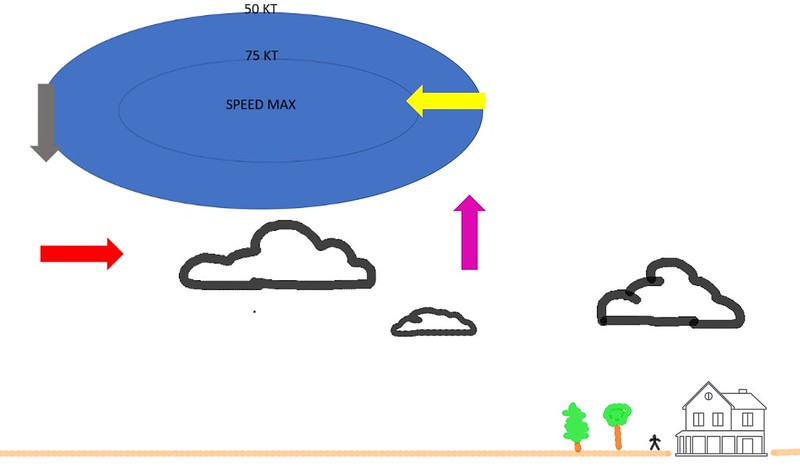
If that is tough to visualize, try this…

This is looking at the Jet Streak like it is the end of a Hair Dryer being pointed at your face. The arrows indicate the direction that the air is moving underneath the core of the Jet Streak. The Red arrow moves from south to north, the Pink arrow from the ground to up in the air, the Yellow arrow then moves the air back to the south, and the Green(ish) arrow then moves it from aloft to down at the surface.
And this is happening over a very large scale.
Because air cools as it rises and warms as it sinks, this type of situation creates a more robust temperature gradient, increased wind shear and can increase instability.
The Setup
Back to the map! Where is this exit region of the Jet Streak?

So, in that area, very generally speaking, we are increasing southerly flow, the temperature gradient, wind shear and perhaps instability. All of those things are ingredients in the formation of severe weather.
Proof of the southerly flow shows up in the 850mb map.
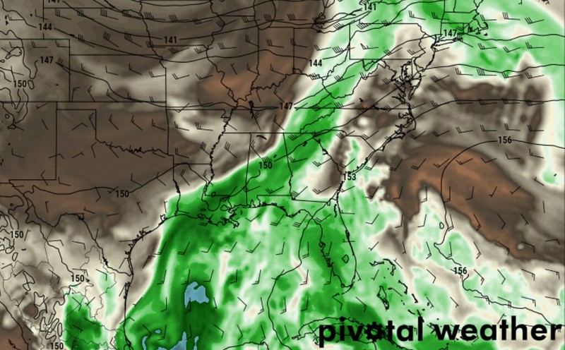
And, at that same time, we have shows and storms in the vicinity.

So we have this very broad rotation within the entire atmosphere increasing shear and instability in the same area where thunderstorms are projected to develop. Seems to me like there may be the potential for a few severe storms.
Looking at the Skew-T data, a lot of these numbers do line up with creating severe weather, too.
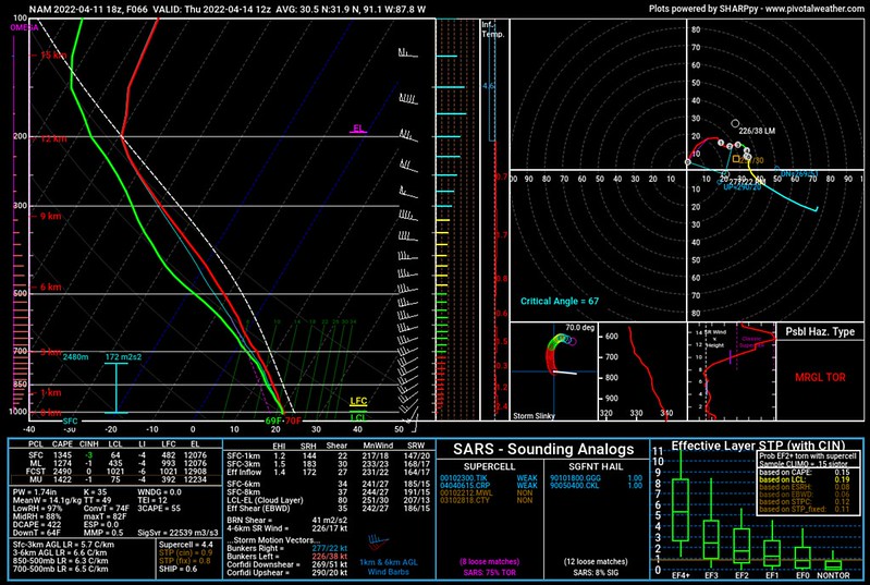
- MLCAPE: 1200J/kg
- DCAPE: 400J/kg
- ML LCL: ~500m
- Bulk Shear: 40-50kts
- 3km Helicity: ~200m/s2
- EIL: 175m2/s2
- SCP: 4.4
- STP: 0.9
Comparing those values with, for example, the historical tornado numbers for the region, you get a data that looks like it has a chance to produce severe weather and the potential to even produce tornadoes.

So then why am I not sold? Because the timing for all of the ingredients seems a bit off.
All of the aforementioned maps and data is for when the cold front arrives, late Wednesday night and into Thursday morning. That is when the atmosphere will be the most ripe…. and by then we may have already watched different storms move through Wednesday evening!
Yes, all of this would be Round Two!
And the Round One storms, Wednesday evening, will be dictated by some very specifically localized atmospheric dynamics. Mainly, model guidance showing a pocket of cooler air floating over from Mexico. And if Round One shakes out like the model guidance is showing, then it would be moving through a reasonably robust atmosphere, too. The Karrie Meter shows plenty of 4s and 5s.
But if Round One is different, by, for instance, the air aloft isn’t as cold, there won’t be as many storms. If it is colder (though I can’t imagine it would be) storms will be more widespread. And more potent.
And if storms on Wednesday evening are more potent, they will likely turnover the atmosphere enough to limit the potential for storms overnight. If they are less potent, they may still perturb things enough to change the math enough that all of this explanation is for naught.
I’m just waiting for Mother Nature to pop up in a Bugs Bunny suit saying, “Ain’t I a stinker?”
The Bottom Line
That is why, in this particular case, I’m still can’t say much with any conviction. I don’t trust the model data yet. I do, however, trust the Storm Prediction Center when they issue their outlooks. They have access to better tools, more data, and much much much smarter meteorologists than I’ll ever hope to become.
And they have part of the area highlighted with an Enhanced Risk, and everywhere else under a Slight Risk. There is a potential for severe weather Between sunrise Wednesday and sunrise Thursday – and that is about all we can say with certainty at the moment.
I could make the argument for a Round One then Round Two scenario, but given the questions around Round One and how that may – or may not – impact Round Two, I don’t feel like breaking it down that way would be very beneficial.
The good news is that it won’t be raining and storming the whole time between sun-up Wednesday and sun-up Thursday. These storms are likely only going to last an hour or two at a time in any one particular spot. Some folks may see rain last for a few hours, but the roughest of the weather should be pretty short-lived.
I’m hoping to get a better feel for things as the data comes in overnight tonight and through the day tomorrow. So please check back for updates.


Good Job!