I’ve had a few folks ask about the Karrie Meter and I was going to hold off until tonight, but I ran the numbers based on the midday data and this is what it kicked back:

This is a much lower number than the SPC is showing. There is a reason. This is about as slam dunk a storm event as you can get. I mentioned that the other day and I think it still holds.
But the severe weather risk, while officially a Moderate Risk (that’s a “4” on the 1-to-5 scale where “5” is the highest risk for the most significant severe weather), still has some wiggle room for things to get both worse and better. And I wanted to take a quick second to breakdown some of the potentials.
DISCRETE STORM MODE VS. CLUSTERED STORM MODE
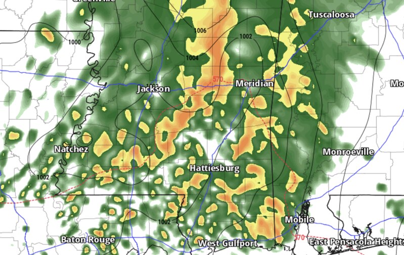
Right now, a lot of the model guidance shows a pretty burly line of storms marching across Louisiana Mississippi and Alabama. But it also shows that stout line of storms slowing down a bit as it traverses Mississippi and getting rather messy.
This will likely determine the severe weather risk for Wednesday. A bit like normal, any storm that fires up ahead of the line will have a higher risk for producing a tornado and larger hail. But the risk for a tornado and larger hail within the line of storms will also be higher than normal.
But, if the storms slow down a bit and get messy like the image above, it would mitigate the severe weather risk as the low-level inflow would get cut off for nearly every storm except the ones on the leading edge and they wouldn’t be moving fast enough to chomp down on all of the “good stuff” (warm, humid air) before it was contaminated with more stable air.
But!
If storms can remain discrete and isolated and the line of storms remains a stout line of storm, then we will see a few tornadoes (one or two stronger than EF2), larger hail, and some very gusty wind (up to 70mph).
TODAY’S RAIN & STORMS
This afternoon’s and tonight’s storms may help dictate how far north the severe weather risk actually develops as it may set the barrier for how far north the warm, moist air can push – even with the strong southerly wind tomorrow.
Here is a look at the spread between the model guidance for how much moisture will be in the air tomorrow morning.
If you blend all of those, you get a map that looks a bit like this:

Where the highest dewpoint values, above 70F, are tied up closest to the coast and the ‘okay’ values (above 65F) are spread northward, but not much farther north than HWY 84. And all values north of that are below 65F
For severe weather, during the day, in April, the threshold for dewpoint values is probably close to about 65F.
During the day tomorrow, we will pool low-level moisture with the southerly flow. But we may not be able to pool enough.
Here is a look at the AI-enhanced model data:
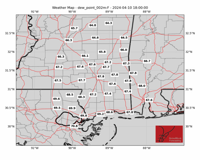
A lot of values greater than 65F, sure, but not many on there higher than 70F.
So we may be able to limit the potency of severe weather north of HWY 84. It would not mean a zero risk for severe weather, but it would limit the risk.
REASONABLE WORST-CASE SCENARIO
Should the storms this afternoon and evening remain farther north and should storm mode remain generally discrete and the line hold together, it is reasonable to predict the potential for a few strong tornadoes tomorrow and the potential for some very strong wind with these storms.
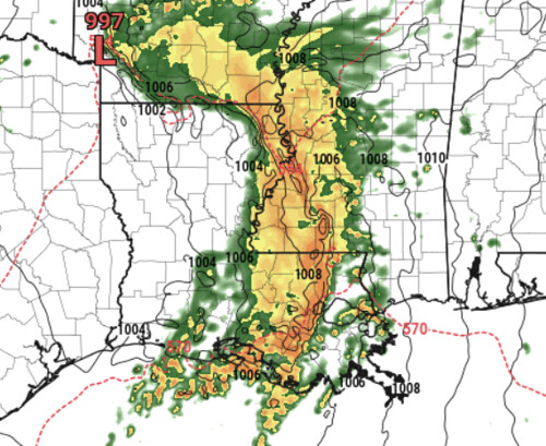
This model, for example, shows the storms holding together and remaining rather sharp on teh leading edge. This would be an example of what it would look like for a “bad” day.
Line that up with a sounding like the one below, and there is a good bet for some reasonably significant severe weather in a few spots. Not everywhere. But in a few spots.

This type of sounding shows a few of the tell-tale signs for severe weather, but also misses in a few spots for us. Given that model data is never fully accurate, that leaves us with a fair bit of space for things to get both “better” and “worse” simultaneously.
THE BOTTOM LINE
I’ll try to have a county-by-county forecast out later tonight with a timeline and the specific potential threats. But do know that you are likely going to be under a Tornado Watch tomorrow and there will be a lot of rain and wind with some localized flash flooding.
It will be a stormy and gross day. For everyone.
And there is the potential for things to be pretty rough with very heavy rain, wind gusts up to 70mph, hail up to the size of half dollars and tornadoes up to EF3 (or EF4) in strength for a few spots.


Thank’s so much!
Thanks Nick!!! Your analysis is appreciated!
I am one of those Jones county folks that still feel a hole when you left. I just can’t get comfortable unless I hear it from you. I still miss you staying with us on the air until danger passed. So I just want to thank you so much for keeping up with us.