If you were on facebook yesterday, you may have seen my ‘super secret map’ that was a preview of early October. It is a look at “Week 3,” as I call it, at work and it is an attempt to forecast beyond Day 14 using a blend of analog dates, teleconnections, and the end of the ensemble model guidance runs.
The map I create is a look at the average temperatures across a full week, not just a single day. And the colors indicate if the temperatures will be warmer than normal of cooler than normal (on the typical scale where red is warm and blue is cold).
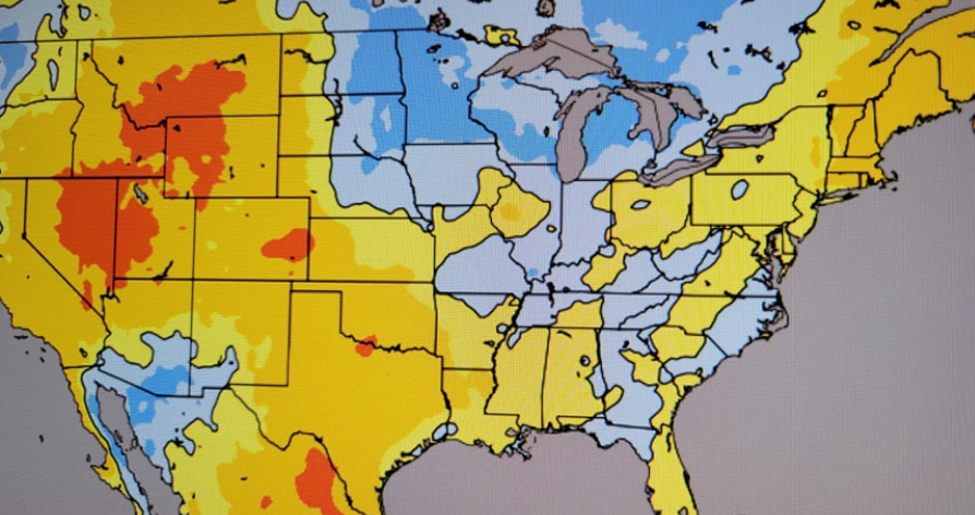
The one I made yesterday, highlighting October 4th through 11th, shows that we will still be “warmer than normal” across our area. But all of that blue on the map in the great Lakes and Ohio River Valley also suggests that the first shot of “cooler air” is on the horizon. And even if we stay warmer than normal generally, there is probably a reasonable chance we have one or two days in there when the temperatures will be cooler than normal.
Those cooler temperatures would also, likely, come with a shot for rain, too. And, honestly, we need both – a cooldown and some precip! So there is some hope on the horizon.
In the meantime, though, it will remain hot and mostly dry with minimal chances for rain during the next week.
[wpcode id=”41149″]
REGIONAL DAY TO DAY FORECAST
Thursday: Mostly sunny. Highs in the lower 90s. Northeast winds 5 to 10 mph.
Thursday Night: Partly cloudy. Lows in the mid 60s. Northeast winds 5 to 10 mph.
Friday: Mostly sunny. Highs around 90. Northeast winds 5 to 10 mph.
Friday Night: Partly cloudy. Lows in the lower 60s. Northeast winds around 5 mph.
Saturday: Sunny. Highs in the lower 90s.
Saturday Night: Mostly clear. Lows in the mid 60s.
Sunday: Mostly sunny. Highs in the lower 90s.
Sunday Night: Partly cloudy. Lows around 70.
Monday: Mostly sunny with a 20-percent chance for storms. Highs in the lower 90s.
Monday Night: Mostly cloudy. Lows in the upper 60s.
Tuesday: Mostly sunny with a 20-percent chance for storms. Highs in the lower 90s.
Tuesday Night: Partly cloudy. Lows in the upper 60s.
Wednesday: Sunny. Highs in the lower 90s.


