A new wrinkle emerged tis morning in the hi-res model data – afternoon storms! The timeline for the line of storms crashing this direction (the “MCS” I talked about last night) from Arkansas has slowed down slightly, but the development of showers and storms ahead of the line is now shown from the HRRR model.
The combo of the slower line of storms and the extra showers and storms developing mean that the froecast is both different and the same – my favorite 🙃.
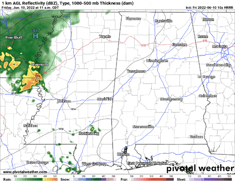
The net result is a very similar forecast for folks across Western Mississippi as the one I posted last night: Storms between 11a and 6p, some severe with the main risk being wind.
That is likely to hold true for places like southeastern Louisiana and coastal Mississippi, too. Afternoon storms develop along the lingering outflow boundaries from yesterday’s storms and then the line of storms (MCS) comes crashing through a bit later in the afternoon – either way, between 11a and 6p storms are possible.
What is changing is the type of storms that will be occurring. Teh impacts will be rather similar.
For southeastern Mississippi and into Alabama, though, it means the potential for storms may shift a bit further into the afternoon – from 2p to 6p. And the potential for severe weather may be a bit lower, too.
So, not a “big” change to the forecast despite the addition of afternoon storms and the MCS taking longer to arrive.
The Asterisk
The afternoon storms that may develop are going to mess with the lowest levels of the atmosphere ahead of the “big” line of storms. It will two two things simultaneously: increase brief tornado threat where outflow from those storms lines up slightly-to-the-left-of-perpendicular to the line of storms. And it will, depending on trajectory, potentially stabilize the environment along the leading edge of the MCS. While warm inflow isn’t as important as the rear-inflow jet, the addition of potentially cooler air in the vicinity will change the structure of the MCS.
In what way? I’ll be total honest here: I have no idea.
Some research suggests that model guidance, in this case, tends to under-forecast potential instability within the MCS. Other research shows that the addition of stable air actually help the MCS propagate. While other research shows a limitation of the MCS intensity.
Because this happens so rarely down here, there isn’t a lot of consensus due to a lack of situations to research. Sometimes it happens one way, other times it happens another, but it hasn’t happened enough to get a good beat on all of the “Five W’s” involved.
If you’re going to throw me in a chair, shine a light in my face and say, “tell us what you know!” I can’t say I know much. But! if you ask my opinion, I would think that the interaction would diminish the MCS’s punch given it would also be an injection of more moisture into the mid-levels. And that any interaction that occurs with any discrete afternoon storms would slowly erode away at the MCS, bringing it to a quicker end.
The Bottom Line
This is still one of those “some people will see some rough weather, others won’t see much of anything out of the ordinary” kind of events. And it looks like the farther east you live, the less you will get. I
The strongest of the storms will produce wind gusting between 40mph and 65mph as the line of storms passes through with very heavy rain, lightning and maybe even some small hail.

If you are on the edges of the line or if you are closer to the Gulf, there is a chance you see wind gusts to 40mph and some heavy rain and lightning. And that is pretty typical for summertime storms.
No matter what, keep an eye to the sky and stay aware of changing weather conditions near you. And when thunder roars, head indoors!


