The Storm Prediction Center bumped up the potential for severe weather across the area tomorrow to an Enhanced Risk. That is a “3” on the 1-to-5 scale where “5” is the highest risk for the most significant severe weather.


Notice that the concern from the SPC is mainly about Wind with a 30-percent Wind Risk area. That would mean that tomorrow we are looking at a 15-to-30 times greater chance for damaging wind than any other regular June day. Pretty high odds.
The Data
Model guidance shows a cluster of storms dropping into the area tomorrow afternoon and into the early evening. Guidance is often a bit slow with situations like this, so when it shows 2p (below) I would tend to lean a bit closer to 12p or 1p.

That said, the HRRR has nailed the beginning of this system pretty well. It called for a line of storms to develop across the Texas panhandle at 10p tonight. And as of this writing, things look exactly how the model suggested. So, it may be on to something.
Here is an animation of the storms passing through, so you can get an idea of the timeline:
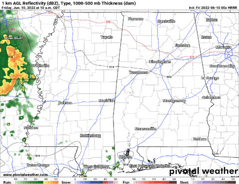
Wind is the main concern. The HRRR model is showing the potential for wind gusts up to 60mph back in behind the leading edge of the rain (below, left). But in this particular case, with the storms already turning a bit outflow dominant across the Texas panhandle, I’d bet this thing will develop a cold pool and ride along with a big push of cold air back in behind a shield of rain. This would mean the “MCS,” or Mesoscale Convective System, would be a self-propagating system (more on that in a second)

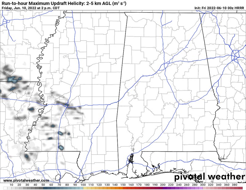
That also means along the leading edge there may be some spots where a brief – and I mean realllyyy brief – tornado may be possible. Looking at the Updraft Helicity streaks (above, right), there are a few splotches, but nothing that would indicate a risk for any long-lived tornadoes

Looking at the Skew-T data, there aren’t any big indicators for tornadoes, either. In fact, nearly all of the ‘important’ signs point toward no tornadoes. Instead, they point toward something else. the propagation of a potential Derecho. The dry air that is between the surface and 500mb is what is needed to keep these MCSs going. And the longer an MCS lasts, and the stronger the wind it produces, eventually it may be classified as a Derecho.
Researchers FTW!
An MCS is a very specific kind of thunderstorm complex that is actually aided by dry air aloft. Here is a snippet from the SPC:
That dry air should be found to be related to the occurrence of derechos and bows is, of course, not surprising. Johns et al. (1990) noted the presence of large dew point depressions at 700 and 500 mb in the vicinity of long-lived derechos. The ingestion of dry air from the pre-storm environment is known to play an important role in the formation and maintenance of surface mesohighs in developing MCSs (Rotunno et al. 1988). Dry air at mid levels is also essential to the formation of strong rear inflow jets (Smull and Houze 1987). Model simulations have shown that rear inflow jets are especially important in fostering mesohigh development in systems which produce large stratiform precipitation areas (Houze 1993).
In contrast, mesohigh development is weak or nearly absent in more saturated environments. As a result, the downshear gust front movement is minimal and low-level convergence will remain focused on the upshear (“back”) side of a developing mesosystem. This idea is consistent with Maddox et al. (1979), Juying and Scofield (1989) and others who found that quasistationary MCSs typically occur within axes of maximum deep-layer theta-e or precipitable water.
The “mesohigh” they mention is a very localized area of high pressure just behind the rain and line of storms. take another look at the estimated radar from the HRRR model.
See that blue “H” in there. That is the mesohigh.
So, while usually you would say, “this summer time heat and humidity make the storms stronger” that isn’t the case in this situation. And if anyone points out “look at the instability!” you can politely say, “actually, research completed in 1996 showed that the speed and direction of the rear-inflow jet play a bigger role than instability in situations like these.”
And because this is a system dependent on a rear-inflow jet with drier air aloft, the presence of increased humid air throughout the column of the atmosphere is actually something that kills these types of systems. This is often why you see them across the Plains and Midwest – far away from the Gulf where it is very humid.
So – in fact! – the more humid it is tomorrow the more likely it is that this thing fizzles out quicker. So where is the humidity? It is locked up south of the boundary left over from storms Wednesday that fired up storms this afternoon.

So, there is a real chance that this thing loses a lot of its punch by the time it makes it to south Mississippi and that many spots – while under an Enhanced Risk for severe weather – may only see some rain and gusty wind and thunder, but nothing worse than normal.
SCIENCE RULES!
The Bottom Line
This is one of those “some people will see some rough weather, others won’t see much of anything out of the ordinary” kind of events. If you get the teeth, look for wind gusting between 40mph and 65mph as the line of storms passes through with very heavy rain, lightning and maybe even some small hail.
If you are on the edges of the line or if you are closer to the Gulf, there is a chance you see wind gusts to 40mph and some heavy rain and lightning. And that is pretty typical for summertime storms.
The timeline for storms is between 11a and 6p Friday afternoon. With the highest risk for the strongest storms between 1p and 4p. The higher risk for stronger storms is west of I-55 and norther of I-20. But the chance for severe storms does extend all the way south to the Gulf.


