In what has been an active period of weather throughout the country, we will continue to see some of the same hazards again over the short term. By the long term, we look to see a change in the upper air pattern over much of the southern US, which will help to suppress the rounds of thunderstorms many have been experiencing and instead allow the heat to build up. Out in the western portions of the country, repeated rainfall chances will continue for many, especially in the intermountain and northwestern US. Strap in, as there is a lot to cover in during this active period of weather throughout the US.
[wpcode id=”41149″]
Severe Weather in the Southeast
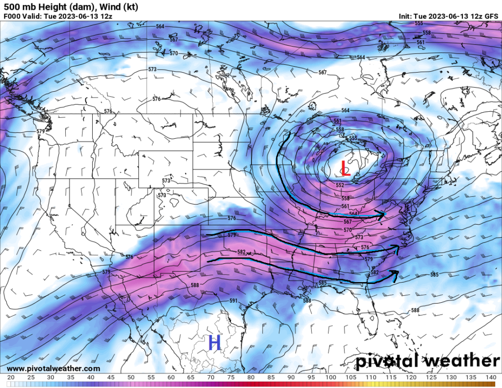
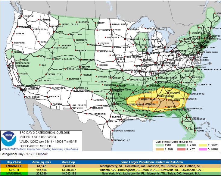
Severe thunderstorms are possible once again for portions of the southeast today and, to a lesser extent, on Thursday as well, with the Storm Prediction Center outlining much of the area in an Enhanced Risk. Taking a broad view of what is going on, we got a closed low sitting off to the northeast over New York and then an upper-level high pressure system sitting over Mexico. In between the two, we got a broad belt of westerly (west to east) flow positioned over much of the southeastern US. Within this flow, potential local disturbances, what we consider shortwaves, will help be the triggering mechanism for these storms to form across the area. Deep Gulf moisture and temperatures in the mid to upper 80s will help to create a very unstable environment favorable for explosive thunderstorms. Ample deep-layer wind shear (wind changing with speed and height) from the surface to around 18,000 feet will also help to foster severe development.
Current hazards for any storm that does reach severe status are damaging winds, large to very large hail, and perhaps a tornado or two will be possible. Timing for these storms look to arrive in two waves. The first wave looks to entail a complex of thunderstorms developing in Arkansas overnight and advancing east-southeastward across Louisiana, Mississippi, and Alabama through the morning hours today. These storms will mostly carry a large hail and damaging wind threat due to their clustered nature, but a tornado cannot be ruled out.
Round 2, beginning at around 3pm CDT, will see the possible development of supercell thunderstorms in Arkansas, Mississippi, and Alabama. These storms will be likely capable of damaging winds, very large hail, and tornadoes. Over time as these storms advance eastward through the evening and overnight hours, we may see these storms become more clustered/linear in nature. If this happens, damaging winds would become the primary threat. These storms will advance through the night before becoming sub-severe by tomorrow.
On Thursday, the severe risk will be much less compared to the day before, with the Storm Prediction Center outlining a Marginal Risk for severe thunderstorms. Leftover thunderstorms from the day before, as well as potentially the formation of new supercells along the coasts of Mississippi, Alabama, and Florida, may still be severe, with large hail and damaging winds the main concern. However, depending on where outflow boundaries from the thunderstorms the day before position themselves, the timing and location of these storms is still a question mark.
[wpcode id=”41149″]
More Rain in the Northwest US
Continued development of showers and thunderstorms will be possible over the next week for much of this region of the country. A series of low-pressure systems look to sweep across the area and help provide a boost to the formation of these storms over the coming days. Flooding may be an issue, particularly today, as these storms move through the region, otherwise rainfall amounts look to remain low overall, but may be higher across portions of Idaho and Montana with heavier bands or more robust episodes of showers and thunderstorms.

[wpcode id=”41149″]
Heat on the Rise in the South
Beginning today and stretching into the latter half of the week and into next week, we will see temperatures begin to really climb for portions of the southern US. The upper-level high in Mexico will begin to strengthen and expand northward into the southern US, allowing for the building of heat and the suppression of showers and thunderstorm chances. Temperatures for several locations across the region look to soar into the upper 90s and low 100s as this high-pressure system builds. Coupled with dew point temperatures in the low to mid 70s (air you could practically wear), heat indices could soar into the 105-110 degree range by the end of the week and into the beginning of next week. Caution will be needed performing outside activities during this time period with the heat. It will be important to stay well hydrated and cool to protect yourself from this kind of weather.
[wpcode id=”41149″]
Travel Impacts for 6/14/2023
Caution will be needed for anyone driving to or through the southeastern US today and tomorrow with severe thunderstorms in the forecast. Multiple ways to receive severe weather information is advised in case you find yourself in adverse weather conditions. Drivers in the northwest should make sure to drive carefully with the continued showers and thunderstorms throughout the week. If you come across any heavy rainfall, slow down and keep a lookout for any flood waters that may be present in the area. As always: Turn Around, Don’t Drown!
[wpcode id=”41149″]
Extended Outlook
By the end of the week and into next week, troughing in the western US will continue to bring precipitation to portions of the northwest while ridging will continue to build over much of the central US. This ridging will help to build and maintain summer-like heat throughout much of this region next week, as well as potentially the week after if the ridge does not budge. Other than that, overall large-scale weather conditions look to be quieting down as we continue into early summer.
[wpcode id=”41149″]
Conclusion
Severe thunderstorms will again be possible today and tomorrow across the Deep South, with all hazards possible, including large hail, damaging winds, and tornadoes. Up in the northwest, occasional wet weather will continue as low-pressure systems eject across the area and provide support for these showers and thunderstorms. Beyond that and looking towards the end of the week and into next, the heat will be on the rise as high-pressure begins to set in throughout the southern US, suppressing storms and bumping up the mercury level on the thermometer.


