
With another shot for severe weather today… A good way to think about today’s weather is one of those March days where a front tries to move through and gets a bit stuck so we get storms that pass through from NW to SE that are mainly wind and hail producers.
The main difference is that it is June and we naturally have more instability and less shear. The high instability means it is easier for storms to get big and burly. But the lower shear means they may be a bit less organized until they are a bit more mature and long-lived.
The latest HRRR guidance shows most of the storms north of I-20 across Mississippi. And I think this may carry some legs – sort of.
Since it is June, I tend to think we will get the seabreeze – like normal – and that may help to shunt some of the initiation of convection farther north. This is what the HRRR is likely seeing, too. So places like Louisiana, some of the southern Mississippi counties, and then coastal Alabama may have less to worry about in terms of a severe risk.
Based on the latest guidance, the general timeline looks like this:

That said, as the seabreeze interacts with the weak front in the area as well as the convection sliding in from the NW, we get into a situation we don’t often see.
Speaking of things we don’t often see: The sounding below.
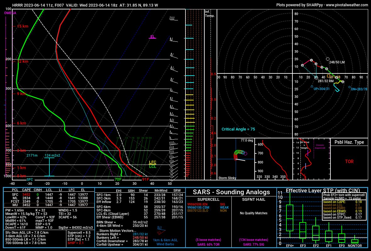
That is Skew-T/sounding you’d see in Oklahoma City in May, not Hattiesburg in June.
That more makes today about of a wildcard as a forecaster.
Not because it will be “really bad” but rather, we don’t see situations like this very often so it is tougher to accurately predict what could happen. But all of that said, a Moderate Risk for severe weather is in place for parts of the area. That is a 4 on the 1-to-5 scale where “5” is the highest risk for the most significant severe weather.
While tornadoes aren’t really in the cards today, wind gusts up to 75mph will be possible as will some large hail. The timeline is from roughly 7a though 7p. But it won’t be storming that entire time. It will be up and down and isolated. So it may storm for a bit then ease back for a few hours then another storm may roll through. So keep an eye to the sky today! And grab the NickelBlock Forecasting weather app!


