The subtropical jet continues to invigorate storms across the south as a stationary front barely moves. Ridging across the plains continues to mute storm development there while upper level lows in the Pacific Northwest and Great Lakes regions continue to keep things cool, but transport wildfire smoke from Canada down into the US. A pattern change coming soon should allow storms to decrease in the South, but allow heat to build in its place.

[wpcode id=”41149″]
Severe Weather Threat across the South and Great Plains
Across the South the story of the past few days will remain the same. A Convectively reinforced stationary front will continue to be draped across the region promoting storm development and severe weather given the instability and weaker shear in the region (compared to the last few days). This portion of the country will continue to see flooding and storms as a risk for those who may be recovering from the rare June severe weather event on Wednesday.
Across the Great Plains, a different story will be had as relatively dry conditions give way to perhaps more stormy conditions due to an advancing cold front. This frontal system will slide out of the Northern Great Plains into a low developing in Southeastern Colorado to give the Southern Great Plains a chance for severe weather. The main hazards will be damaging winds and hail, but an isolated tornado cannot be ruled out either along the cold front to the north, the dryline to the west, or the triple point intersection of these features in the northwest. The timeline on these storms will be in the evening to overnight hours so make sure to have multiple methods to wake you up in case a bad storms impacts you!

[wpcode id=”41149″]
Rainfall across the West Continues
The abundant rainfall across the West continues today with flooding risks possible across several states. We owe this rainfall to an upper low that is currently situated along the Montanan-Canadian border promoting lift across the west. This low will continue to slide eastward slowly leading to more storm development and thus higher rainfall totals across the region. Remember to turn around and don’t drown if you encounter any flooded roadways!
[wpcode id=”41149″]
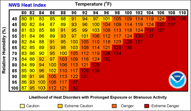
The Heat Risk Continues to Build Across The South
As we move into this weekend, an upper level pattern change looks to take shape as our subtropical jet relaxes and allows for ridging to build. This pattern will lower storm chances across the South, but at the cost of increases to the heat during the day. Parts of Texas and Oklahoma will likely see highs in the 100s and maybe even 110s with heat indices perhaps a little higher due to dewpoints being in the 70s. Across the rest of the South temperatures will be in the low to mid 90s with higher heat indices due to dewpoints being in the 70s. This pattern should be received with caution as those who work outside or members of our at risk populations will need to take extra care to not harm themselves from the heat. Wear light clothing, using methods of cooling, and take breaks in order to stay happy and healthy during the heat.

[wpcode id=”41149″]
Travel Impacts for 6/15/23
Areas across the South will continue to see impacted travel from not only the severe storms expected today, but from any recovery impacts from the previous days. Additionally, areas across the Great Plains mays also see travel impacts due to severe weather. Areas out west may see impacts from flooding but those will be far more isolated then the severe weather threat and thus less widespread.
Extended Outlook 6/15/23
By weeks end and into next week, troughing in the western US will continue to bring precipitation to portions of the west while ridging will continue to build over much of the central US. This ridging will increase our temperatures into a more summer-like heat throughout much of southern region next week, as well as potentially the week after if the ridge doesn’t move. Other than that, overall large-scale weather conditions look to be quieting down as we continue into summer.
Conclusion
With quieter weather on the horizon, hopefully this upcoming pattern flip will be able to allow some communities a reprieve from the severe weather they are experiencing. Caution to anyone working outdoors in the long term as heat can cause health issues if appropriate measures are not taken.


