
Thunderstorms are not quite out of the forecast this week! After yesterday’s severe weather, our area is predicted to have more storms coming our way. As the Short Range Forecast predicts we can see a low pressure system moving some scattered storms to our area starting today and into tomorrow with about a 60% chance of storms both days. Storms would be scattered across the region due to the hot temperatures coming this weekend.
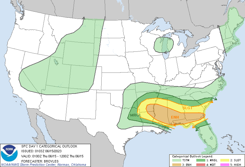
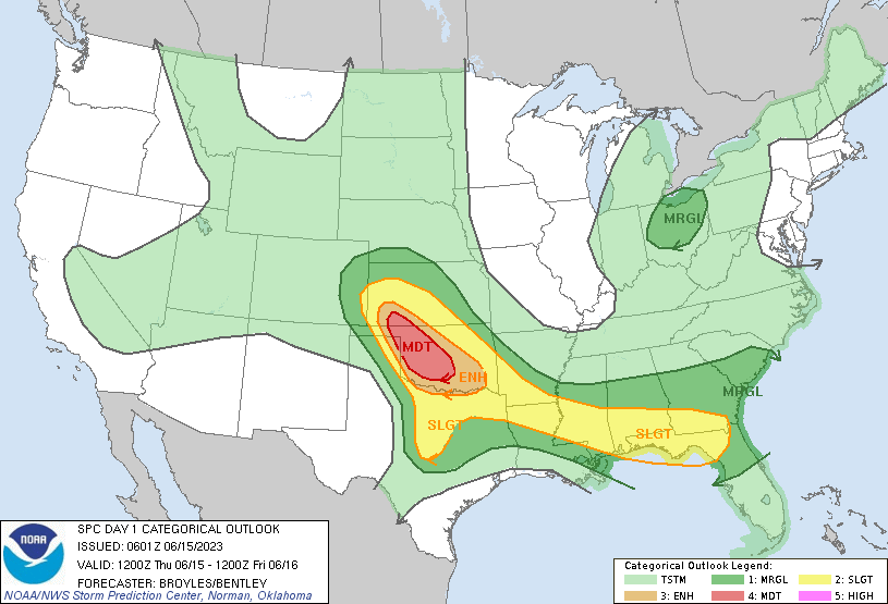
Currently, the Storm Prediction Center has our area under the Enhanced Risk category for the morning hours. This means we have a higher chance of storms that can produce some damaging winds and heavy rainfall. Make sure you are prepared on the morning commute! By the afternoon however, our risk level is lowered to Slight with the chance of thunderstorms about 40%. As we look ahead more we see less heavy rainfall in our area for the weekend.
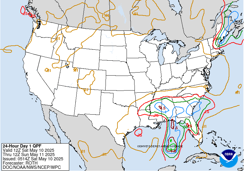
Looking at our Precipitation Prediction for today, we can see our area getting anywhere from .25 inches to 2 inches in some parts. The amount of rainfall will vary on how scattered the storms are. Central and Southern Mississippi are forecasted to see the most rain in the area. Many of these storms will take place in the early morning as remnants of yesterday’s storm activity. As a low pressure system moves in from the west we can see some more rainfall Friday and into the rest of the weekend. Due to the incoming hot weather, chances of afternoon showers and thunderstorms are high.

Thinking ahead, we can see on the GFS forecast model a deep trough extending across the midwest down towards our area. This area of low pressure will bring in some rain and chance at some scattered thunderstorms. After Monday, we see less chance for rain and mostly clear weather for the week as a high pressure systems comes in with some warm temperatures.
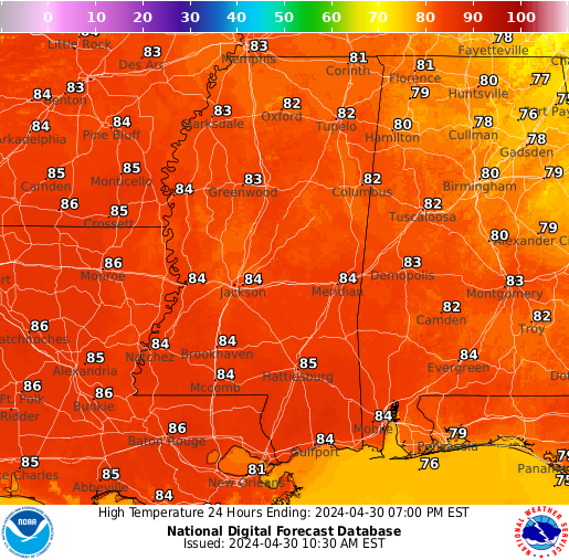
Summer is just around the corner and the temperatures are showing it. With some highs nearing 100 degrees today it feels like summer already. Southeastern Louisiana is going to see the hottest highs in the area with Baton Rouge forecasted to hit 97 degrees today. Most of Southern Mississippi will see temperatures in the low 90s as well as parts of Southern Alabama. The humidity levels will be high with is common for this region this time of year.
Make sure to keep hydrated when working outdoors and only stay outside for short periods of time if possible. We are getting into the hot months of the year and keeping yourself safe outside is crucial. Be sure to wear lots of sunscreen and turn up the AC because it’s going to be HOT!
[wpcode id=”41149″]
REGIONAL DAY-TO-DAY FORECAST
Today: Mostly cloudy. Chance of scattered showers and thunderstorms in the morning before noon. High temperatures in the upper 80s to low 90s. Winds south, southwest at 5 to 10 mph. Chance of rain 60%.
Tonight: Mostly cloudy. Chance of showers and thunderstorms after 9pm. Low temperatures in the low 70s. Winds light and variable. Chance of rain 40%.
Friday: Partly sunny. Showers and thunderstorms likely throughout the afternoon. High temperatures in the upper 80s to low 90s. Winds south, southwest at 5 to 10 mph. Chance of rain 60%.
Friday Night: Partly cloudy. Chance of showers and thunderstorms before 1am. Low temperatures in the low 70s. Winds southeast around 5 mph. Chance of rain 40%.
Saturday: Mostly sunny. Chance of showers and thunderstorms throughout the day. High temperatures in the mid to upper 90s. Winds southwest around 10 mph. Chance of rain 40%.
Saturday Night: Partly cloudy. Chance of showers and thunderstorms. Low temperatures in the low to mid 70s. Winds west, northwest around 10 mph becoming south later in the evening. Chance of rain 30%.
Sunday: Partly sunny. Chance of showers and thunderstorms throughout the day. High temperatures in the mid to upper 90s. Winds south, southwest at 10 to 15 mph, with gusts as high as 25 mph. Chance of rain 30%.
Sunday Night: Partly cloudy. Chance of showers and thunderstorms. Low temperatures in the mid to upper 70s. Winds south, southwest at 10 to 15 mph, with gusts as high as 20 mph. Chance of rain 40%.
Monday: Mostly sunny. Slight chance of showers and thunderstorms. High temperatures in the mid to upper 90s. Winds are light and variable. Chance of rain 30%.
Monday Night: Partly cloudy. Slight chance of showers and thunderstorms. Low temperatures in the mid to upper 70s. Winds are light and variable. Chance of rain 30%.
Tuesday: Mostly sunny. Slight chance of showers and thunderstorms. High temperatures in the mid to upper 90s. Winds are light and variable. Chance of rain 40%.
Tuesday Night: Partly cloudy. Slight chance of showers and thunderstorms. Low temperatures in the mid 70s. Winds are light and variable. Chance of rain 30%.
Wednesday: Mostly sunny. Slight chance of showers and thunderstorms. High temperatures in the mid to upper 90s. Winds are light and variable. Chance of rain 40%.


