As far as the blob in the Gulf… Texas and Louisiana? Likely rain. Mississippi and Alabama? Probably not as much rain. Florida? Almost nothing.
For Invest 94L it is probably a bit too early to make any assessment for the Lower 48, but I would lean toward “minimal impacts” at the moment given that most model guidance isn’t as concerned with a US landfall.
But it is still so early that I wouldn’t ‘check out’ on the forecast. This is something to ‘check back’ on later this week.

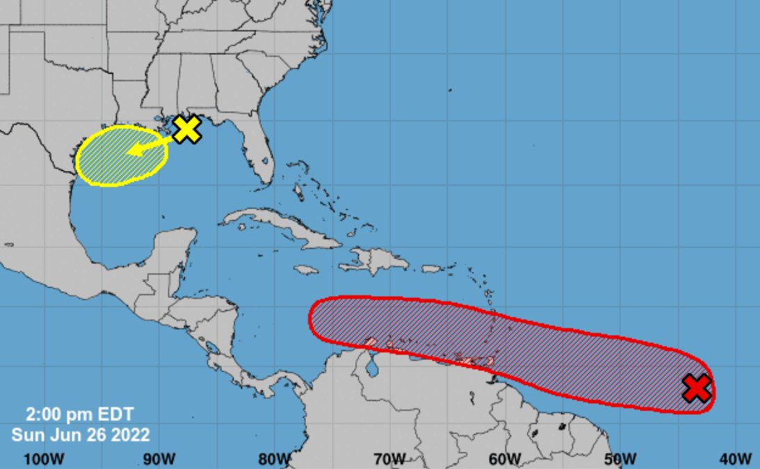
But first things first! The blob in the Gulf.
Blob’d
The progression of the little area of spin from the GFS computer weather model shows not much in the way of movement next week. From Monday through Thursday it just hangs out off the Texas coast. Take a look at the movement from the GFS computer weather model on Pivotal Weather:


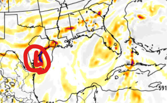

It isn’t just the GFS showing the potential for a system out there. Most models are doing a decent job picking up on there being ‘something’ out in the Gulf spinning around, but the magnitude of the spin is in question. Some models show more spin than others while one or two show barely enough spin to ID where the center may even be.
But that is just a “spin” in the atmosphere. That doesn’t mean there will be any kind of organized tropical system floating around.

Instead, it looks like the main threat from this area of interest is more about ‘impacts’ than ‘name’ because it may never organize itself into anything more than spinning cluster of rain – but it may be a lot of rain.
Both the Euro and GFS show a splotch of rainfall totals exceeding 10″ during the next five days. One offshore and the other over Texas.
Both models also show the potential for 2″-to-4″ of rainfall across parts of southeastern Louisiana, southern Mississippi and Lower Alabama during the next five days. That includes the chance for rain on Monday that has nothing to do with this little tropical riff-raff.
But it does mean there will be a chance for showers and storms starting today (Sunday) that lingers through Friday morning.
Instead of a “landfall” of a tropical system for Mississippi or Alabama, this will instead just make it easier for the atmosphere to produce some showers and storms. And thus more rain is possible.
Invest 94L
Invest 94L is the wave that is a little better organized out into the Atlantic.

While it doesn’t look like much now, it is still struggling to get wrapped up for a few reasons. The leading reason is its proximity to the equator. This thing is around 8-degrees North. That is about 400 miles from the equator.
And that matters! Because things don’t spin on the equator. There is no Coriolis Force. So the closer these tropical systems are to the equator, the tougher it is for them to develop because they can’t get spinning very easily.
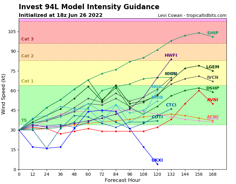
But the current thinking is that this one will lift far enough north to start to wrap itself up during the next 24-to-48 hours. Once it does that, the model guidance is pretty well set that it will become a tropical storm.
And then it will march through the Caribbean. And right now, guidance is also showing a rather tame Caribbean for tropical systems. Often, this time of year the Caribbean is very inhospitable for tropical development with a lot of shear in the region.
But right now, that isn’t as much the case. Not sure I believe it. But that is what is shown.
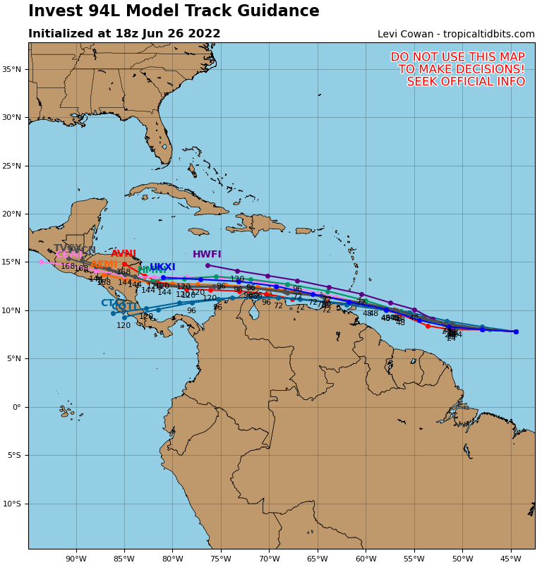
Model guidance shows a consensus that it will make a run toward Central America by next weekend. I tend to lean toward the HWFI shown above where this system meanders a bit farther north and into the central Caribbean.
That would put it somewhere in the western Caribbean by next weekend – still at least three days away from any potential US impacts. So, your Fourth of July parties and BBQs will not be impacted by this system.
And again, the consensus here is that it moves into Central America never bothering the US.

My biggest question mark revolves around what happens Friday when this thing – however strong or weak it is – gets to the periphery of the ridge to the north. And is that ridge even still there? Or is it stronger?
That is going to dictate if we need to truly worry about Invest 94L or not.
But that start point for concern isn’t until this Friday. Five days from now.
The Bottom Line
The blob off the coast of Texas will probably give a boost to the chance for meaningful rain during the next week. How much rain will depend on a few things, but I actually wonder if its specific location even matters. Because, based on the latest model guidance, for southern MS/AL/LA the push of moisture off the gulf is going to be what bumps the chance for rain, not the direction interaction with the system itself.
As for Invest 94L, we don’t even need to think about worrying about that thing until this Friday. Keep tabs on the forecast for sure, but no need to change plans or even make a back-up plan at this point.
Instead, I would recommend using these two potential systems as a reminder that it is Hurricane Season and now is a good time to think about how much water you have, how much food you have and if you have all the supplies you would need to live for up to a week without power or running water.


