
This summer is proving to be one of the hottest summers on record with no signs of letting up as we make our way closer into August. While the West Coast will be getting a slight break from this heat and rain, the rest of us will not be so lucky today and this week.
Storms Across the Great Plains and Southeast

As we saw that sweeping cold front move across the Great Plains earlier this week, the front has begun to stall a bit from the low level flow of wind from the Gulf. These winds will also help supply moisture for much of these storms along the Gulf Coast extending inland. These storms will not be quite as severe as the weather resulting from this front yesterday, however there is still a risk for heavy rain and possible flooding throughout the region.
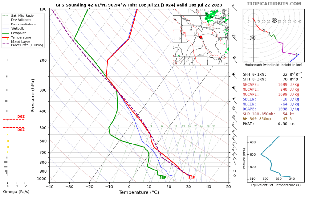
The Great Plains will also be at risk for some possible isolated thunderstorms later in the evening as strong daytime heating will create significant instability. This will promote the development of possible multicells late this evening throughout the Upper Midwest region. Shear is another important factor to look at when considering the possibility of mutli and supercell systems. Shear helps aid in the formation of the intense weather systems but too much shear can also rip them apart before they get a chance to develop. Generally, we look for the range of 25-40 knots within the layer as a rule of thumb for possible development.
Heavy Heat Across the US Inbound
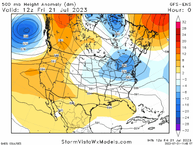
We will be seeing a significant shift in the mid-level weather pattern over the next week as our trough out east will pretty strongly de-amplify. This will allow for these already dangerously hot temperatures across the US to rise further along the Ohio Valley and Great Lakes region. While yesterday temperatures in the 90s stretched across the entire southern half of the US, this week will have these temperatures spread across Central US and extending further north up the East Coast while California will be seeing some relief from their current heat trend.
The Great Plains and Great Lakes regions again will be affected the most by this shifting pattern with most places reaching well into the upper 90s and even hitting past 100 degrees across the Central US. Especially for the Great Lakes region, these temperatures are well above what is normally expected in the summertime so always take extreme caution when out in this heat for any amount of time. Heatstroke and other related illnesses can occur within minutes when not taking the necessary precautions. Always remember to stay hydrated!


Travel Outlook
Traveling along the Southern Gulf Coast will likely lead you into some areas of heavy rain and flooding so be careful and ready to pull over in case of unsafe conditions. The Upper Midwest and Great Plains region will be looking pretty clear for the daytime but later into the evening will risk strong chances of strong thunderstorms and the possibility of isolated large hail.
Extended Outlook

As a result from this weakening upper level trough, precipitation will be able to sneak its way further north for an above average chance of rain next weekend. The Great Lakes region into Canada will see some pretty anomalous rain while Eastern US will begin to feel some of that dryness from the West move it way in. Meanwhile, the West Coast will settle back into normal conditions.


