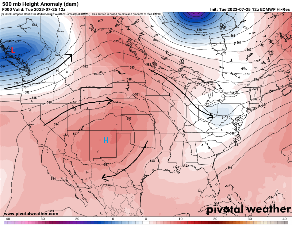
Busy forecast today as we got an active period of weather across the contiguous US in the short-term. Strong high pressure over the southern half of the country will leave many dealing with hot to very hot summertime temperatures, while the northern tier under westerly flow aloft may see the potential for severe thunderstorms over the next few days. Overall, this upper-level pattern will exist over the next 7 days, as is most common for this time of the year.
[wpcode id=”41149″]
Severe Threat in the Great Lakes and Eastern Seaboard
Severe thunderstorms will be possible this afternoon across portions of eastern Lower Michigan, central and eastern Indiana, and northern Ohio. An incoming robust shortwave and associated surface low from the northwest will begin to move into the area and help to trigger and maintain thunderstorms coming in from the west, some of which may be severe. As it stands currently, this is shaping up to be more of a bimodal event, with a line or two of thunderstorms moving through Lower Michigan and possibly more discrete, supercellular thunderstorms further south into Indiana and Ohio.
Substantial moisture and modest CAPE values of 1500+ J/kg will help set the stage for strong thunderstorms to develop by mid-afternoon. This along with favorable wind shear will help to maintain the severe potential with these storms as they interact with this unstable environment. Up north into eastern Michigan where forcing may be stronger and directional shear slightly weaker, a more linear mode will be favored with damaging winds being the primary hazard.
However, this directional shear will also help provide a favorable environment for embedded/QLCS tornadoes within the main line or main clusters of storms. These storms will be most likely arriving by around 10am and exiting the area by 10pm.
Further south into Indiana, Ohio, and southern Michigan, severe thunderstorms will look to form by the evening hours and progress eastward into the night. Some morning showers will help to stave off the development of storms until enough atmospheric recovery can take place to set a more unstable environment by the late afternoon.
Overall forcing down here is a bit weaker, but the vertical wind shear is more favorable for discrete supercells instead of a large line segment like up north. All hazards (large hail, damaging winds, and a few tornadoes) will be possible with these storms as they develop and move east with time. The greatest severe threat will largely be possible between 1pm and 10pm, with storms eventually moving out of the area by early tomorrow morning.
Tomorrow, the severe threat will shift further east to encapsulate the Northeast Corridor. The same system that impacted portions of the Great Lakes today will move through tomorrow and help carry over any remaining thunderstorms, as well as help initiate new development by the late morning/early afternoon. Substantial CAPE values of up to 3000 J/kg will help provide the necessary juice for foster robust thunderstorm development as a cold front interacts with the unstable air. Damaging winds and a couple tornadoes will be possible in the wake of moderate to strong vertical wind shear, while modest to steep lapse rates will support a large hail risk as well.
Thunderstorm chances will begin as early as 8am, with the most optimal time for severe thunderstorms being between 11am to 9pm.
[wpcode id=”41149″]
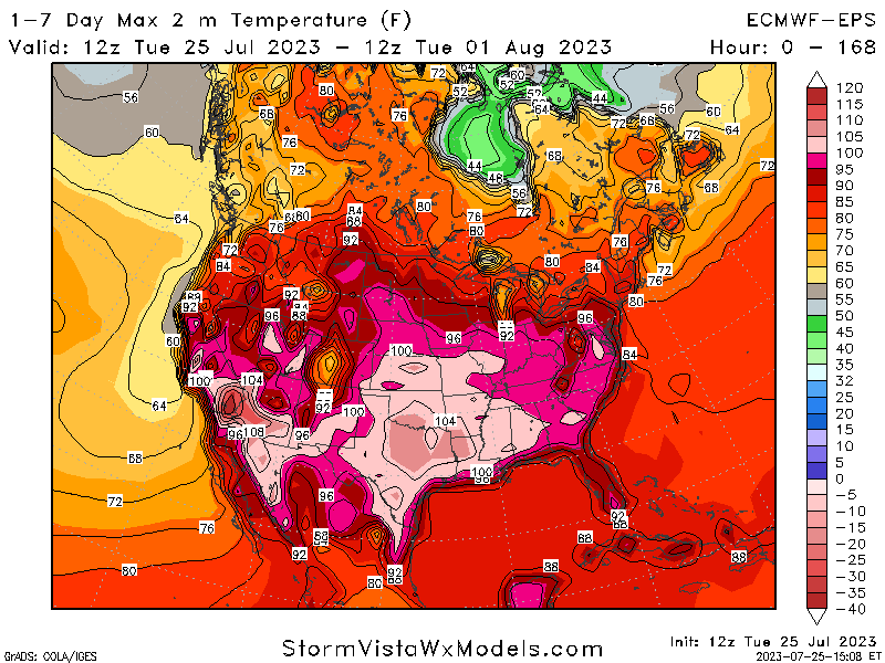
Very hot in the western half of the country
The heat will stick around for a good while as high pressure will continue to sit and build over western and central United States. Daytime high temperatures for many here will average in the upper 90s to low 100s. Heat Advisories and Excessive Heat Warnings have already been issued over multiple days in the southern and central part of the country for heat indices up to 105 to 110 degrees, and further expansion of these advisories may be possible as the heat continues to build and hang around.
Winds are also expected to be very breezy for many across the region. This, paired with dry to very dry air, will support a substantial fire risk, with areas in Idaho and Montana currently under a Red Flag Warning for critical fire conditions.
[wpcode id=”41149″]
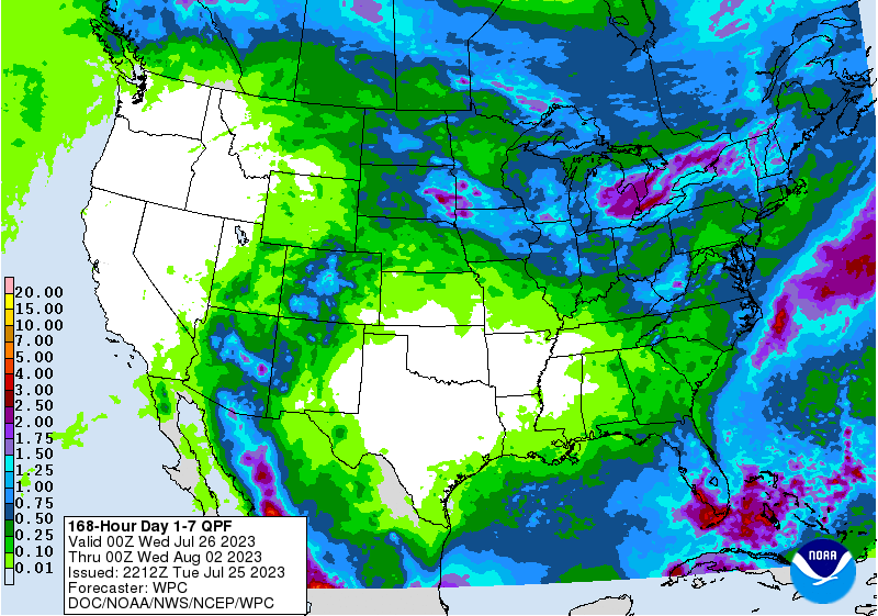
Monsoon rains make an appearance in the Southwest
Aside from the heat, daily chances for showers and thunderstorms will also exist around the Four Corners states as the summer monsoon kicks in, Rich moisture in the mid-levels being pulled in from the Pacific Ocean by this high-pressure system will sustain continued scattered showers and thunderstorm development across the region over the following days. These storms will largely be triggered by the diurnal heating cycle, forming once the convective temperature is reached and dissipating by the evening hours as heating shuts down. Heavier downbursts may bring a flash flood potential and as such, local conditions should be monitored during these thunderstorms.
[wpcode id=”41149″]
Extended Outlook
This high-pressure system will stay largely co-located over the western half of the country over the next 7 days. Two scenarios may play out with the evolution of this system, with either A) High pressure spreads out further south and becomes more elongated, displacing the westerly flow further north into the northern US and moving organized convective chances northwards, or B) High pressure gets amplified and influence form low pressure hangs around in the eastern US, leaving consistent and organized convective potential around where it currently is (Midwest to Eastern Seaboard). Either way, regardless of the scenario, the heat in the western half will persist in the long-term and monsoon rains remaining a staple in the southwest.
[wpcode id=”41149″]
Travel Outlook
Travel delays will be anticipated across portions of the Midwest (Detroit, Cleveland) and the Northeast Corridor today and tomorrow as severe thunderstorms move through the area. Expect delays and cancellations to flights in and out of the regions and adverse driving conditions with heavier downpours and high winds. Multiple ways to receive weather warnings is advised, especially when your route takes you through these areas where storms are possible. Elsewhere, travel throughout the rest of the country will be largely unaffected, although flash flooding will be possible in the southwest US over the next week with scattered thunderstorms present daily.
[wpcode id=”41149″]
Conclusion
Severe thunderstorms will be a concern for several in the Midwest and Eastern US today and tomorrow as a potent disturbance makes its way through the region, bringing the risk for hail, damaging winds, and even tornadoes. Further specific information can be found at the Storm Prediction Center’s website, or on your local news station or local National Weather Service office. Elsewhere, searing heat will continue to bake the western half of the country over the next week and monsoon rains will pour over the Four Corners region. This trend looks to continue over the long-term, as high pressure will remain rooted in the west and any organized storm chances will remain off in the north and eastern US.


