Tonight storms will form across the midwest Great Lakes region with the potential for strong winds, hail, and heavy rainfall. The south will see some dry weather as we turn up the heat across the south and western US. Low pressure out west will bring some wet weather to the Rockies and central plains this week. Let’s dive into these patterns!
[wpcode id=”41149″]
Storms Across Great Lakes and East
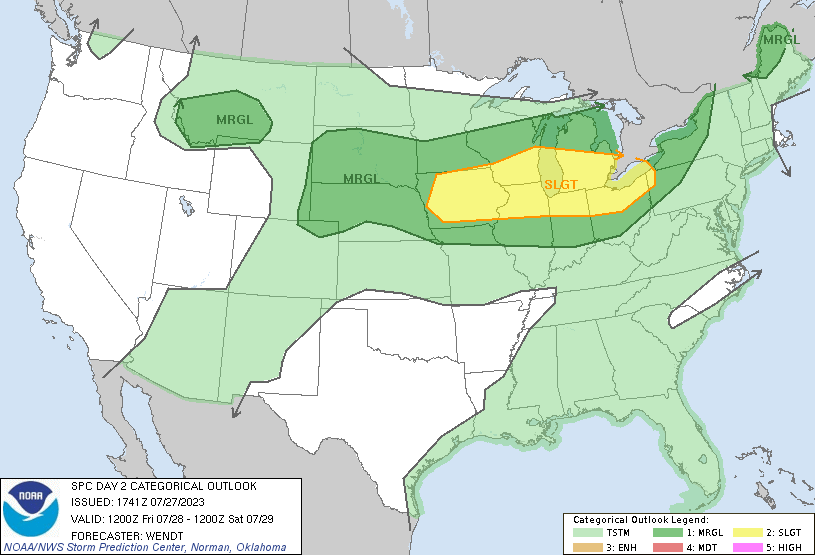
Tonight we are watching a storm system form across the Great Lakes around Michigan and Wisconsin. Lots of rain be spread across much of the midwest and Ohio valley with some scattered thunderstorms with the potential for hail. This rain event will move across Pennsylvania and its intensity will die down bringing just some rain to the northeast.
The east coast will get some rain this weekend in the north. Saturday much of Vermont, New Hampshire, and Maine will see rain. Saturday night a scattered convective storm will make its way across the Mason Dixon line bringing isolated thunderstorms and showers. Rain will come to the southeast later in the weekend. Over the week clear weather will stick around in the week until next Friday when we see a large storm system spread across the east.
[wpcode id=”41149″]
Rocky Mountain Rain
Across the Rocky Mountain west we are seeing a low pressure system stabilize itself across the region alongside some warm moisture in the air to start some storms. Scattered rain showers and thunderstorms will form in Colorado, Wyoming, and Utah within the next few days. Some of these storms will band together to create some systems that will effect the central plains such as Kansas, Nebraska, and Oklahoma the following day. This moist pattern will stick around for the next week or so as the low pressure remains in the area.
[wpcode id=”41149″]
CONUS Heat
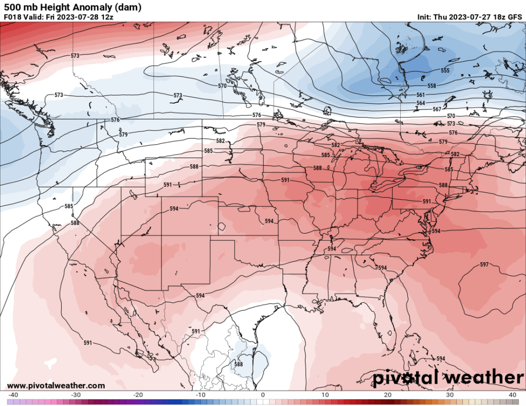
Heat expands itself from coast to coast this week as we experience summer all across the country. The southern US will experience highs in the 90s to 100s. The central US and east coast will see hot temperatures today and over the weekend. As the week progresses the south will remain very hot. Ridging across the central US will keep this heat around for the week as well the dry air surrounding the area. Heat warnings are in effect for much of the south this weekend and fire warnings in the west due to the dry air. Heat indices are in the 100s meaning being outside is not recommended. Always be cautious outside in hot temperatures and be sure to stay hydrated and drink water!
[wpcode id=”41149″]
Travel Impacts
Tonight rain and thunderstorms will be across the midwest and northeast so be prepared for slick roads and airport delays. Traveling in the north northeast be sure to be prepared for rain as well. Down south scattered afternoon storms are possible due to the intense heat. If you’re taking a vacation to the Rocky Mountains this week be sure to pack rain gear and be prepared for some storms across the area. Be sure to check local traffic delays and flight departures before traveling.
[wpcode id=”41149″]
Extended Outlook
Looking at the next 15 days for the US we will be this heat remain across the southern US and building a bit into the central plains region. The northern half of the country will be warm or on average for heat. As for precipitation it looks like the northern US will see above average rain while the south stays dry. The Rocky Mountain region and Great Lakes area as we discussed will be above average for a little while. This is will a pattern that continues for at least the next week as we head into August.
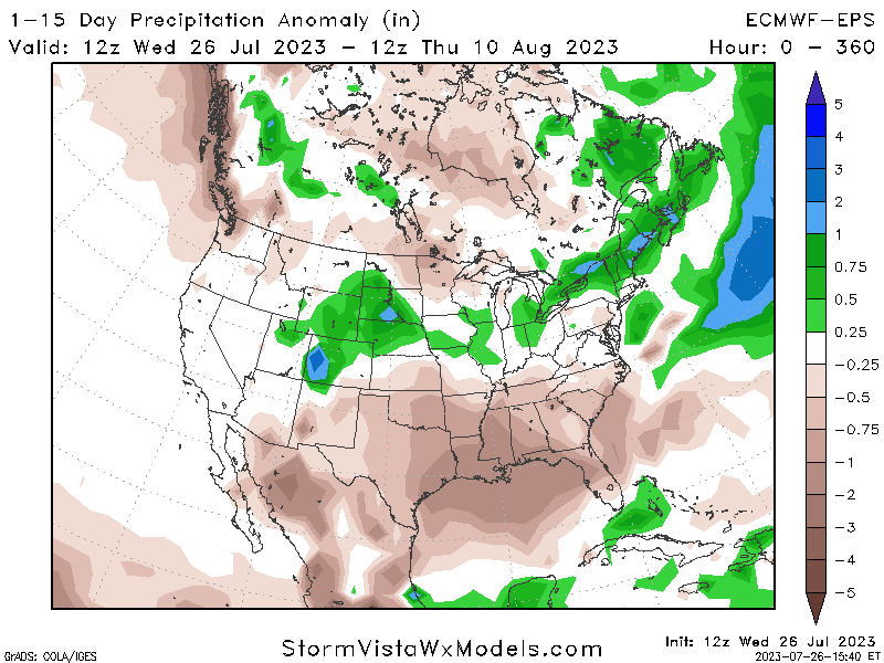
Precipitation Anomaly for 1-15 Days 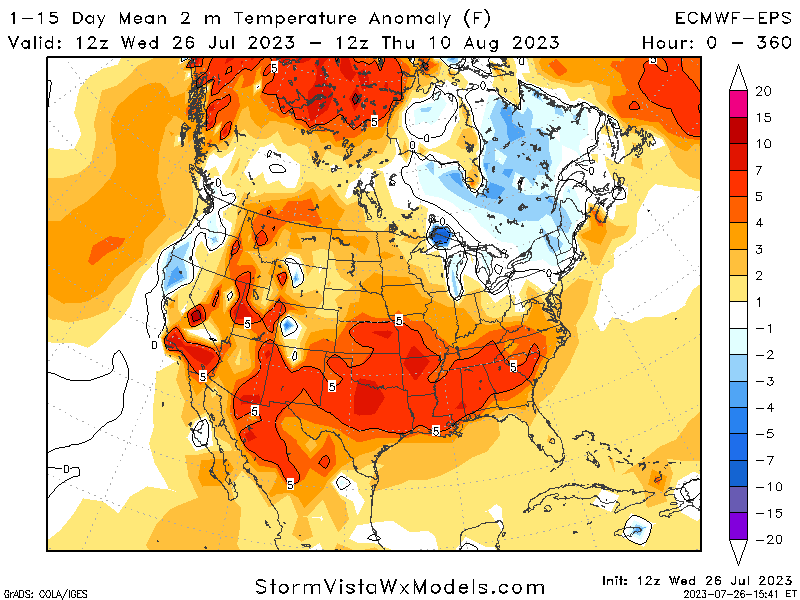
Temperature Anomaly for 1-15 Days
[wpcode id=”41149″]
Conclusion
Storms tonight will hit the Great Lakes area and spread to the northeast over the weekend. The Rockies will be a storm creator this week as we see temperatures start to warm up in the west. The south will be the hottest and driest with the potential for wildfires in some regions and heat warnings across the south. It will be a big separation between wet and dry regions this coming week as we get into August. Always be sure to check your local forecast for more detailed information for your area!


