A familiar summer time pattern has shown itself this week and looks to be in place at least for the next week bringing typical summer impacts to the US. With a high pressure out West and a Low pressure hanging out in the East summer impacts in the form of heat out West, Storms in the plains, and a combination of both in the southeast look to impact the US. Let’s dive into the details below!
[wpcode id=”41149″]
Heat Builds Out West
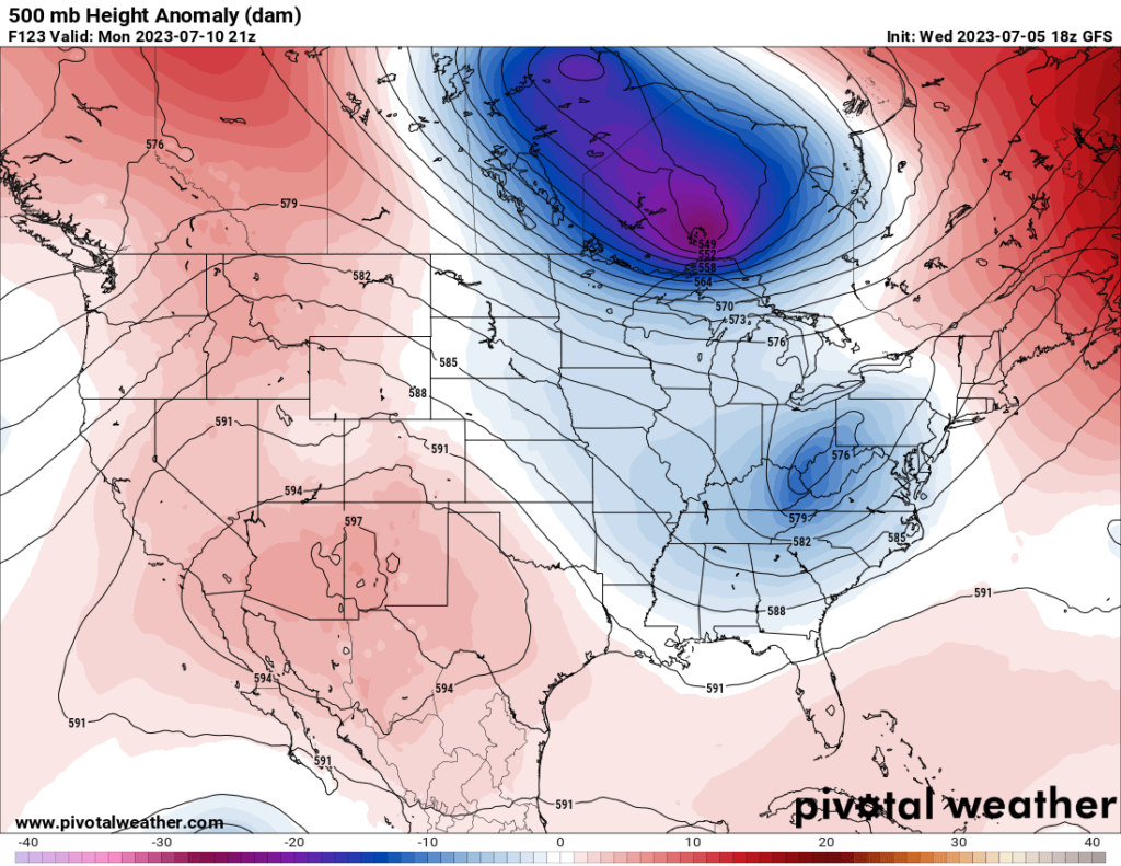
As we can see from the 500mb map, we have an area of high pressure located over the West, and an area of low pressure located in the East. This pattern is very typical for summer and as such the impacts associated with this type of pattern are pretty well understood. Ridging out West will lead to heat to build. Temperatures across the West could soar into the 100s with highs in some locations being in the 110 – 115 mark. It hasn’t really gotten this hot our there yet this year so folks should take extra care if working outdoors or traveling as they may not be fully used to the heat yet. This set up will also reduce storm development across the region which is running above average in terms of rainfall.
[wpcode id=”41149″]
Storms Across the Plains
Storms once again look possible across the Plains as embedded shortwaves create lift in a region with decent moisture and instability. As has been the story for the past few weeks, the expectation for several mesoscale convective systems (MCSs) to impact the region appears fairly likely and will result in damaging winds, hail, and isolated tornados.
The first of these complexes is currently ongoing across portions of the central plains bringing damaging winds and small hail across the region. The expectation is for this complex to drift into the lower Mississippi Valley and bringing a renewed severe weather threat to the region as day time heating occurs.
Further north, an embedded shortwave will traverse the Rockies and provided enhanced lift to the region. This should result in several clusters of thunderstorms forming and bringing all severe weather hazards to the region including damaging winds, hail, and tornadoes. These storms will most likely grow upscale as night falls and form into one or several MCSs and bring with them damaging wind and hail impacts across the plains. One thing is for sure, these MCSs will brining beneficial rainfall to main across the region which should help crops not damaged by high winds!
[wpcode id=”41149″]
Storms and Heat across the Southeast
Across the Southeast a combinations of heat and storms looks to be in store as a lingering frontal boundary and the remains of MCSs cause storms to fire across the region. Any portion not impacting by these storms will be under the effects of dangerous heat and heat indices as temperatures climb into the 90s with dews pushing heat indices into the 100s. Remember to stay hydrated and use shade if you are working out in the heat for extended periods of time!
[wpcode id=”41149″]
Extended Outlook
Overall, little change in this air pattern through the next 7 days. High pressure will continue to hover over the southwest and keep temperatures up, west-northwesterly flow aloft will help to maintain rain chances and potentially severe weather for the central US, and general upper-air patterns over the southeast US will keep the seasonal weather in play without much change in the way of temperatures or rainfall potential at this time.
Travel Impacts
Potential travel impacts would largely be in the Plains where thunderstorms (some severe) could bring hazardous road conditions and flight delays or cancellations over the next week. Outside of showers and thunderstorms in the eastern half of the country, travel conditions should be quite pleasant across the United States. Make sure the AC works in your vehicle, especially if you travel through the southern and western parts of the country where temperatures will be quite hot and toasty.
[wpcode id=”41149″]
Conclusion
High pressure over portions of the southwestern US will keep temperatures around or exceeding 100°F over the course of the week, showers and thunderstorms in the Plains fueled by westerly flow and moist, unstable air will remain a possibility through the near future, and the southeast should experience familiar summertime conditions for this time of the year.


