El Nino conditions are continuing to contribute its fair share in keeping the Atlantic basin relatively quiet so far this hurricane season. The same cannot be said over in the Pacific as of late, as last week we had two named hurricanes in quick succession of each other. Overall, increased activity in this basin will look to continue over the next week or so, as long-range guidance continues to hint at some form of development off the coasts of Mexico and Central America. Conditions in the long-term will remain very favorable for tropical development over here, as opposed to the Atlantic. Let’s take a look at these two basins and decipher what is going on.
[wpcode id=”41149″]
Current Tropical Conditions
The Pacific Ocean continues to be more active than the Atlantic so far this year. Two potential areas of interest are of note off the southwest coast of Mexico. The westernmost of these disturbances has the greatest potential of organization over the next week or so. Weak wind shear off to the north and west of this disturbance will help to promote gradual development, as this system moves off to the northwest over the coming days. Eventually, after a few days of intensification and organization, this area looks to become an organized tropical disturbance by the early weekend. This storm and its impacts should remain out in open waters as it moves away from the Mexican coast, although locally heavy rainfall may occur.
Close in the same region, ensemble members are hinting at the possibility of another disturbance trying to form behind the aforementioned one. Organization looks to hold off until next week, as wind shear in the region is strong enough to prevent this, although this will change once upper-air conditions calm by early next week. It is still a little early to pick out specific impacts or intensity of this potential system, so for now, a watchful eye will have to be kept on this area over the coming days until a clearer picture is painted.
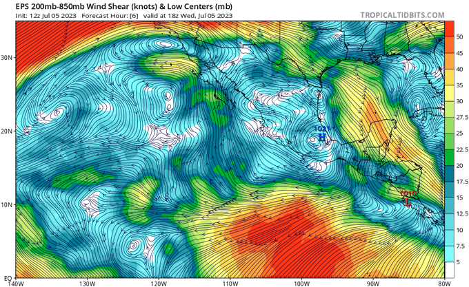

Out in the Atlantic, conditions overall remain mostly the same as in previous days. A vigorous subtropical jet over the Atlantic is giving any wave coming off the west coast of Africa, as well as any opportunistic storm in the Caribbean, a really tough time at staying organized once it moves over the warm waters of the Atlantic. Very dry air is also overspreading much of the Atlantic basin currently also. As such, organized tropical storms are not likely to occur at this time.

[wpcode id=”41149″]
Extended Outlook
Main areas for tropical organization over the long-term look to mainly be in the East Pacific Ocean. Conditions out here are much more favorable for tropical storms than in the Atlantic, mostly due to the reduced amount of wind shear and deep moisture. Both the GEFS and EPS ensemble members reflect this by hinting at the possibility for more organized tropical systems to develop over the next two weeks, whereas both members are keeping the Atlantic Ocean largely quiet.
[wpcode id=”41149″]
Conclusion
The Pacific Ocean, especially the Eastern Pacific, will be the most active over the next couple of weeks. A couple areas of unsettled weather will try to gather themselves into organized tropical systems, with the earliest window for an organized storm forming being around the early weekend. The second area behind it may potentially get itself together by sometime early next week. As always, this is a fluid situation and sudden changes are always possible with these systems. Contrastingly, the Atlantic Ocean looks to remain devoid of most tropical activity for the foreseeable future. Atmospheric conditions remain very unfavorable (strong wind shear, very dry air) for tropical storms.


