As Invest 92L drifts south toward the Gulf of Mexico, the models are starting to show their cards in terms of why things will eventually look like they are going to look, and why – as forecasters – it is very difficult to nail down specifics.
Up at 10,000 feet
A game of tug-og-war is being played up at 10,000 feet in a manner of speaking. Not because anything is really ‘pulling’ anything else, but mainly becuase I can’t think of a better way to analogize it.
I’ve been talking about the two ridges of high pressure for the last week and how the fight between the two is going to be what ultimately dictates where Invest 92L goes. And now that we are within about 48 hours of something brewing, the model data is starting to show us exactly what it is thinking.

In the above map, you can see the two ‘H’ areas signifying the areas of high pressure. The’L’ is Invest 92L. The tellow live indicates isobars (lines of similar air pressure) up at 700mb. The placment of all of these things is being estimated by the GFS computer weather model. The map is looking 45 hours out.
Compared to just 24 hours ago, look at how far east the yellow lines are across parts of Arkansas, Mississippi, Tennessee, Kentucky and Missouri. Those lines were not suggested by the model to be in those locations 24 hours ago. In fact, the yellow line closer to the H wasn’t there at all! This indicates that the model is suggesting the ridge across the Rockies may be stronger than originally anticipated.

And a stronger ridge – one that is stretched to the east across the central plains – means there is a better chance Invest 92L continues to drift west longer. If the ridge isn’t as strong nor stretched out, there is a better chance Invest 92L flips north sooner. Particularly if the ridge to the east, the Bermuda High, is set farther east.
Then there is another crinkle. The trough in the Great Lakes region. If that trough is ‘squashing’ the ridge in the Rockies and flattening it out… that would stretch it farther east, too. And that would keep Invest 92L moving west.
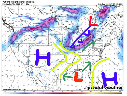
Unless the ridge isn’t squashed, but rather cut off. That would allow Invest 92L to slide north quicker.
Things get complicated quickly
I suppose this is a great example of how forecasting tropical systems isn’t easy. And this is just one factor – of many factors – that go into determining track. The strength of the storm is another factor, particularly with this storm, that goes into determining track. But I won’t get into that on this post.
That is why meteorologists tend to use ensemble models and spaghetti plots to look at track. Because it can give forecasters a much more detailed look at all of the possible outcomes.
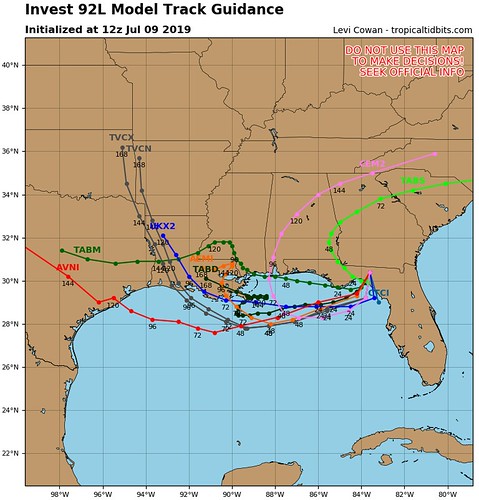
The spaghetti models this morning are starting to come into a better consensus that it will track more westerly than southerly during the next two days.
So what’s it going to do?
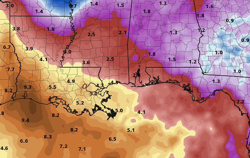
Rain. There will be a lot of rain. Where ever it goes, there will be a lot of water. And even some places that it just passes by will get soaked, too. That is the one thing that we do know. If you live within 100 miles of the Gulf Coast between Pensacola and Houston prepare for 2″ to 6″ of rain. Maybe more.
And with wind gusts of around 20mph to 30mph possible (at a minimum) there is a good chance some trees get knocked down, too. That means there could be power outages as well.
The system isn’t moving quickly, either. So this will start Wednesday at the earliest, and linger around until Sunday at the latest.
What should I do now?
If you live in a flood-prone area, assess your surroundings. Is the creek near your house clear of debris? Are the storm drains clogged? Fix those things now. If a Flash Flood Emergency was issued for your area, do you know where to go? Find a safe place from flooding now.
While this isn’t anticipated to be some Monster Hurricane, prolonged rain can cause serious problems. Flooding is the deadliest form of severe weather. It kills more people than tornadoes. So please take it seriously.
Also check your Hurricane Preparedness Kit. That’s about it. Make sure you have enough supplies to last a few days without power and water. Not because this system is anticipated to wipe out power and water to an area, but rather, you should always have enough supplies to last a few days without power and water during Hurricane season.


