I know everyone is thinking about what is going on in the Gulf or should I say what will be going on in the Gulf. Well the good news is the next two days will be normal summertime days with nothing tropical to worry about. After Wednesday and Thursday it will be all eyes on the tropics but till then enjoy the next two days in my short term forecast!
Wednesday – It will be warm tomorrow so make sure to take breaks and drink plenty of water if you have to be outdoors at all. The high temperature tomorrow will be around 96 degrees but we will see a 30 percent chance of rain so if you are lucky you will get a shower tomorrow afternoon and cool off for a little bit. The low temperature overnight will only get down around 76 degrees so we won’t cool off much during the overnight.
Thursday – One good thing it won’t be as warm for Thursday the high temperature will be around 94 degrees. We will see periods of clouds through the day but rain chances for the day will be slightly lower at 20 percent but once again if you are the lucky one who sees a shower you will cool off for a little bit. We don’t cool off all that much overnight lows will be down around 75 degrees for Thursday night.
Now that I have you set up for the next two days Noah will tell you all about this tropical stuff that will come in over the weekend.
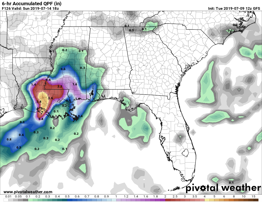
It looks like the tropics decided to spark up a little early this season! Instead of developing off the coast of Africa, we instead have a tropical invest that is being birthed in our home field, the Gulf of Mexico. Many of the models agree that this invest (or people who overhype already call it Barry) is going to be moving westward towards our neck of the woods and intensifying with all the warm water it wants to ingest.
While there is one model that implies it’s going to strengthen to a small hurricane, I would tend to disagree, but one thing is for certain that it will be moving slowly and dumping plenty of rain in Louisiana and potentially in Mississippi. The NAM model is saying the invest is supposed to keep moving west, however most of the others like the European, GFS and the Canadian models show the system moving upwards with southeastern Mississippi receiving the eastern portion of the invest.
Friday has an increase in clouds keeping our overall temperature slightly cooler throughout the day. Overnight into Saturday is when we’ll see the rain moving in. High of 89, low of 74 and winds SE at 5-10 mph.
Saturday is when the rain starts coming in consistently. Winds will increase since the storm will be close in proximity and overall rain will be around 1-3 inches. High of 84, low of 72 and winds SE at 10-20 mph.
Sunday we’ll get rain constantly pouring with 2-4 inches possible. A few thunderstorms and wind are probable with the storms moving inland. High of 82, low of 70 and winds S at 10-15 mph.
Monday morning is when the rest of the rain moves through the Pinebelt while the rest of the day will be cloudy. Over an inch of rain is still possible in the morning hours. High of 87, low of 69 and winds SE at 5 mph.
Tuesday we start to go back to normal with some clouds still remaining over us to keep temperatures a little cooler than average. High of 90, low of 72 and winds SSE at 5 mph.
Flash flooding and high winds are possible with this invest. Please be careful driving and have a back up plan in case this system gets worse because anything is possible with the tropics.


