Before we dive into the noes from the National Hurricane Center, it is important to mention that as the data from the Hurricane Hunters continues to get ingested into the models, the forecasts will continue to change slightly. But I would bet that another shift in the forecast is coming – this time for Laura – during the next 24 hours.
The data is starting to suggest that the ridge in the Atlantic may give more of a “push” to Laura, and move the storm further west. At the same time Marco is going to be quite the small storm and should fall apart over land pretty quickly.
Those two details may allow Laura to slide nearly all the way across the Gulf before turning north and northeast. That would slide the landfall from places like MS/LA to places like Texas.
So if you are reading this in places like Lake Charles, LA to Houston, TX – or know someone who lives near there – please pay very close attention to the forecasts for Laura during the next 24 to 36 hours. As the forecast has the potential to change.
I’ll be looking through more of the model data this morning, and will have some more info later today.
Tropical Storm Marco

MARCO STATS
LOCATION…24.2N 87.1W
ABOUT 210 MI…340 KM NW OF THE WESTERN TIP OF CUBA
ABOUT 360 MI…580 KM SSE OF THE MOUTH OF THE MISSISSIPPI RIVER
MAXIMUM SUSTAINED WINDS…70 MPH…110 KM/H
PRESENT MOVEMENT…NNW OR 335 DEGREES AT 13 MPH…20 KM/H
MINIMUM CENTRAL PRESSURE…993 MB…29.32 INCHES
WATCHES AND WARNINGS
A Storm Surge Warning is in effect for….
* Morgan City Louisiana to Ocean Springs Mississippi
* Lake Borgne
A Hurricane Warning is in effect for…
* Morgan City Louisiana to the Mouth of the Pearl River
A Storm Surge Watch is in effect for…
* Sabine Pass to Morgan City Louisiana
* Ocean Springs to the Alabama/Florida border
* Lake Pontchartrain, Lake Maurepas, and Mobile Bay
A Hurricane Watch is in effect for…
* Intracoastal City Louisiana to west of Morgan City
* Lake Pontchartrain, Lake Maurepas, and Metropolitan New Orleans
A Tropical Storm Warning is in effect for…
* Mouth of the Pearl River to the Mississippi/Alabama border
* Lake Pontchartrain, Lake Maurepas, and Metropolitan New Orleans
A Tropical Storm Watch is in effect for…
* Mississippi/Alabama border to the Alabama/Florida border
A Storm Surge Warning means there is a danger of life-threatening inundation, from rising water moving inland from the coastline, during the next 36 hours in the indicated locations. For a depiction of areas at risk, please see the National Weather Service Storm Surge Watch/Warning Graphic, available at hurricanes.gov. This is a life-threatening situation. Persons located within these areas should take all necessary actions to protect life and property from rising water and the potential for other dangerous conditions. Promptly follow evacuation and other instructions from local officials.
A Hurricane Warning means that hurricane conditions are expected somewhere within the warning area. A warning is typically issued 36 hours before the anticipated first occurrence of tropical-storm-force winds, conditions that make outside preparations difficult or dangerous. Preparations to protect life and property should be rushed to completion.
A Storm Surge Watch means there is a possibility of life-threatening inundation, from rising water moving inland from the coastline, in the indicated locations during the next 48 hours. For a depiction of areas at risk, please see the National Weather Service Storm Surge Watch/Warning Graphic, available at hurricanes.gov.
A Hurricane Watch means that hurricane conditions are possible within the watch area.
A Tropical Storm Warning means that tropical storm conditions are expected somewhere within the warning area within 36 hours.
A Tropical Storm Watch means that tropical storm conditions are possible within the watch area, generally within 48 hours.
For storm information specific to your area in the United States, including possible inland watches and warnings, please monitor products issued by your local National Weather Service forecast office. For storm information specific to your area outside of the United States, please monitor products issued by your national meteorological service.
DISCUSSION
Thunderstorm bursts continue to fire near the center of Marco, then weaken an hour or two later due to persistent shear. Overall, the storm’s appearance hasn’t changed with nearly all of the deep convection very near or northeast of the center. Although the satellite presentation is somewhat lacking at the moment, the earlier Air Force Reserve Hurricane Hunter mission found believable SFMR values to 60 kt, so that value remains the initial wind speed.
The intensity forecast remains tricky with Marco due to its small size and marginal environment. There are some models that briefly relax the shear today, which will likely be enough of a change to allow Marco to reach hurricane strength. Later on, while the cyclone is near the coast of Louisiana, the shear is forecast to increase, but it is unknown exactly how close to landfall this will occur. Our best forecast at this time is that the strongest winds will be confined to the coast, and that Marco will then weaken faster than most hurricanes do over the swamps of Louisiana due to the shear. No significant changes were made to the intensity forecast, which is very close to the model consensus. The new forecast necessitates the issuance of hurricane warnings for portions of southeastern Louisiana.
Marco continues moving north-northwestward or 335/11 kt. This general track and speed is likely today, with a turn to the northwest and decrease in forward speed expected as the storm weakens late Monday. While the track forecast is essentially unchanged from the previous one, there is still a fair bit of spread in the model guidance, likely tied to the intensity forecast. The stronger guidance is near or northeast of the new model consensus, due to the upper-level flow, and the NHC forecast leans in that direction, close to the previous official prediction.
KEY MESSAGES
1. Hurricane conditions, life-threatening storm surge, and heavy rainfall are expected from Marco along portions of the Gulf Coast beginning on Monday, and Hurricane and Storm Surge Warnings have been issued. Interests in these areas should follow any advice given by local government officials.
2. Tropical Storm Laura could bring additional storm surge, rainfall, and wind impacts to portions of the U.S. Gulf Coast by the middle of next week. This could result in a prolonged period of hazardous weather for areas that may also be affected by Marco. Interests there should monitor the progress of Marco and Laura and updates to the forecast during the next few days.
FORECAST POSITIONS AND MAX WINDS
INIT 23/0900Z 23.7N 87.0W 60 KT 70 MPH
12H 23/1800Z 25.3N 87.6W 65 KT 75 MPH
24H 24/0600Z 27.3N 88.6W 65 KT 75 MPH
36H 24/1800Z 29.0N 89.7W 65 KT 75 MPH
48H 25/0600Z 29.9N 91.5W 45 KT 50 MPH…INLAND
60H 25/1800Z 30.5N 93.1W 30 KT 35 MPH…INLAND
72H 26/0600Z 31.0N 95.0W 25 KT 30 MPH…INLAND
96H 27/0600Z…DISSIPATED
Tropical Storm Laura
LAURA STATS
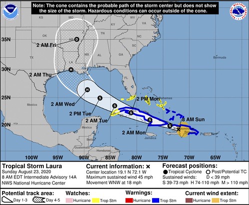
LOCATION…19.1N 72.1W
ABOUT 40 MI…65 KM NNE OF PORT AU PRINCE HAITI
ABOUT 50 MI…80 KM S OF CAP HAITIEN HAITI
MAXIMUM SUSTAINED WINDS…45 MPH…75 KM/H
PRESENT MOVEMENT…WNW OR 285 DEGREES AT 18 MPH…30 KM/H
MINIMUM CENTRAL PRESSURE…1005 MB…29.68 INCHES
WATCHES AND WARNINGS
A Tropical Storm Warning is in effect for…
* The northern coast of the Dominican Republic from Cabo Engano to the border with Haiti
* The southern coast of the Dominican Republic from Cabo Engano to Punta Palenque
* The northern coast of Haiti from Le Mole St. Nicholas to the border with the Dominican Republic
* The southeastern Bahamas and the Turks and Caicos Islands
* Cuban provinces of Camaguey, Las Tunas, Holguin, Guantanamo, Santiago de Cuba, Granma, Ciego De Avila, Sancti Spiritus, Villa Clara, Cienfuegos, Matanzas, Mayabeque, La Habana, and Artemisa
A Tropical Storm Watch is in effect for…
* The central Bahamas
* Andros Island
* Florida Keys from Ocean Reef to Key West and the Dry Tortugas
* Florida Bay
* Cuban province of Pinar Del Rio
A Tropical Storm Warning for the Dominican Republic and Haiti means that tropical storm conditions are expected somewhere within the warning area today. The Tropical Storm Warning for the Cuban provinces means that tropical storm conditions are expected somewhere within the warning area during the next 24 to 36 hours.
A Tropical Storm Watch means that tropical storm conditions are possible within the watch area, generally within 48 hours.
For storm information specific to your area in the United States, including possible inland watches and warnings, please monitor products issued by your local National Weather Service forecast office. For storm information specific to your area outside of the United States, please monitor products issued by your national meteorological service.
DISCUSSION
aura has maintained an impressive convective pattern despite the center being located over extreme south-central Dominican Republic. Numerous cloud tops of -85C to -90C have been noted over the Barahona peninsula, an indication that extremely heavy rainfall has been occurring there. The center of Laura passed over or very near Santo Domingo around 0430Z based on a noticeable wind shift that was measured at the international airport. Laura’s outflow pattern has also continue to improve in all quadrants. The initial intensity of 40 kt is based on earlier scatterometer and aircraft data, along with surface observations along the north coast of the Dominican Republic.
Laura has continued to move west-northwestward and the initial motion estimate is now 285/16 kt. There has been a significant westward shift in the latest NHC model guidance, which appears to be due to most of the global models taking the center of Laura farther south over central or southern Hispaniola rather than emerging it off the north coast of Haiti like the GFS is and has been forecasting. Given that the most intense convection has persisted along the southern coast of Hispaniola, that is where the most likely area that a low-level and/or mid-level circulation is most probable to develop or persist. As a result, the new NHC track forecast favors a more southerly and westerly track solution similar to the preponderance of the track guidance. However, the new forecast track has not been shifted as far to the left as the consensus models in the event that the models shift back to the north. However, the latter scenario is appearing less likely based observed satellite trends since the previous advisory.
Little if any significant change in strength is expected due to Laura moving pretty much down the spine of Hispaniola and Cuba during the the next 36 hours, with the strongest wind likely remaining over water in the northeast quadrant where the pressure gradient will be the tightest between the cyclone and the Bermuda High. By 48 hours and continuing until landfall, Laura is forecast to remain in a low shear and very favorable upper-level outflow environment while passing of extremely warm SSTs near 31C. This should allow for significant strengthening to occur once the cyclone regains a decent inner core after exiting Cuba. The new NHC intensity forecast is a blend of the intensity forecasts by the GFS and ECMWF global models and the corrected consensus models HCCA and
FSSE.
KEY MESSAGES
1. Tropical storm conditions are expected across portions of the Dominican Republic and Haiti, the Turks and Caicos, the southeastern Bahamas, and Cuba through Monday. Heavy rainfall is likely across these areas and could cause mudslides and flash and urban flooding.
2. Tropical storm conditions are possible the central Bahamas and Andros Island tonight and Monday, and in the Florida Keys on Monday.
3. The details of the long-range track and intensity forecasts remain uncertain since Laura is forecast to move near or over portions of the Greater Antilles through Monday. However, Laura is forecast to strengthen over the Gulf of Mexico and could bring storm surge, rainfall, and wind impacts to portions of the U.S. Gulf Coast by the middle of next week. This could result in a prolonged period of hazardous weather for areas that are likely to be affected by Tropical Storm Marco earlier in the week. Interests there should monitor the progress of Laura and Marco and updates to the forecast during the next few days.
FORECAST POSITIONS AND MAX WINDS
INIT 23/0900Z 18.8N 70.9W 40 KT 45 MPH
12H 23/1800Z 19.8N 73.7W 40 KT 45 MPH…OVER WATER
24H 24/0600Z 20.9N 77.5W 40 KT 45 MPH…INLAND
36H 24/1800Z 22.2N 81.1W 40 KT 45 MPH…INLAND
48H 25/0600Z 23.5N 84.2W 45 KT 50 MPH…OVER WATER
60H 25/1800Z 24.9N 87.0W 60 KT 70 MPH
72H 26/0600Z 26.4N 89.4W 75 KT 85 MPH
96H 27/0600Z 29.9N 92.5W 85 KT 100 MPH
120H 28/0600Z 35.0N 91.4W 30 KT 35 MPH…INLAND


