As anticipated, Tropical Storm Marco continues to move north toward the central Gulf Coast. People in Louisiana and Mississippi will need to continue to monitor forecasts closely. Tropical Storm Laura, also somewhat anticipated, is now looking more and more like a Louisiana and Texas threat than a Florida and Alabama concern. Mississippi isn’t completely out of the woods just yet for Laura.
So let’s dive into some things. Here is a (shorter than last time) look at what we know, don’t know, can’t know and want to know…
NHC Forecasts
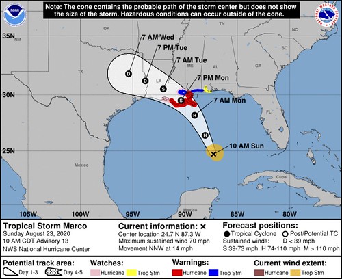
Marco
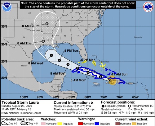
Laura
What we know
Two tropical systems don’t merge to form one super-big tropical system
This is still not how physics works. Thankfully! I can’t imagine living in a world where tropical systems merged to form bigger tropical systems. No thank you.
Plus these systems will be too far away for that to even be a thing – if it were possible – that would happen anyway.
Marco is now a hurricane
Marco is a stout storm for being pretty beat up. The Hurricane Hunters were flying through the storm this morning found evidence of hurricane-force wind through surface estimations of dropsonde data.
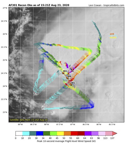
That is a look at their flight path and the wind speeds at each point. You can see on the NE side, a patch of hurricane-force (65kt or greater) wind.
Marco’s run at becoming a hurricane is something that will have direct and indirect impacts on Laura as it enters the Gulf.
Hurricane Hunter data is helping
A lot. This is why it is so useful to have them flying around in these storms. While what they do is dangerous, it helps meteorologists immensely and int urn, helps the public.
So, big props to them!
The ridge in the Atlantic is moving west
You can see this on satellite. Big thanks to the College of DuPage for their awesome GOES page. Take a look at the imagery below.
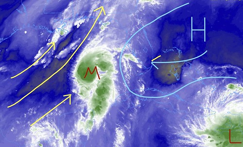
You can see that the ridge is nudging to the west. And Marco is currently caught between the shear of the trough (yellow lines) and the ridge to the east (blue lines). This is not great news for Marco’s development. On the one side, it has wind peeling the clouds away from the center, and on the other side, it has a ridge nudging it further into the wind shear that is peeling the clouds away from the center.
What we don’t know
how much will Marco play a role in Laura?
That last sentence in the last section leads us here. We don’t know how much Marco will directly or indirectly change how Laura evolves and moves. There is some research out there to suggest possible outcomes, but most of the research is based on perfectly-modeled systems and the world is far from a perfectly-modeled system.
And the eventual impacts could shove Laura further in any direction along its path toward the Gulf Coast – where ever that may be.
There is some discussion about how Marco may lead to an enhanced ridge in the Atlantic. That enhanced ridge may push Laura further west. Or MArco could flatten the ridge, allowing for Laura to have a quicker turn to the north.
It is still an unknown at this point.
How Marco will change the water temperature in the Gulf
I know many people will say, “But Nick! It is SO WARM!”
Those people are not wrong. The waters are still quite warm. In fact, it would be argued that even if Marco rained itself out, there would still be plenty of warm water to sustain a tropical system in the Gulf.
However, the question I have is more about magnitude rather than the binary ‘yes/no’ at this point. Because Laura is now pegged to be a Category 2 Hurricane at landfall, I think it is important to note just how much energy it will have access to ‘right out of the gate’ as it enters the Gulf.

So far the islands of the Caribbean have posed no real issue for the storm, so if it gets into the open waters of the Gulf and has access to an Isotherm that is deeper rather than shallower, it will have the ability to begin intensifying nearly immediately. If it moves over, even slightly, cooler-than-before-Marco waters, what will be the impact? We don’t know. But it may be worth watching.
What we can’t know
Where Marco & Laura are going, specifically
I know this is what everyone wants to know, but sadly we just can’t know these things. What we can estimate is the spread of potential outcomes and the spread of potential impacts… But specifics, we can’t really offer. The science just isn’t that good yet.
Who will see the eye of the storm
Along the same lines, because we don’t know specifically where each storm is going, we can’t know where the eye of the storm will be.
What we want to know
Outside of having our Magic 8 Ball tell us all the right answers? Well it would be nice to know a few things.
What the heck is THAT thing?!
Okay, so that sounds dramatic. But there is a little lee-side area of low-pressure that develops within some of the modeling across parts of West Texas and Oklahoma by Tuesday / Wednesday.
We would love to know more about that.
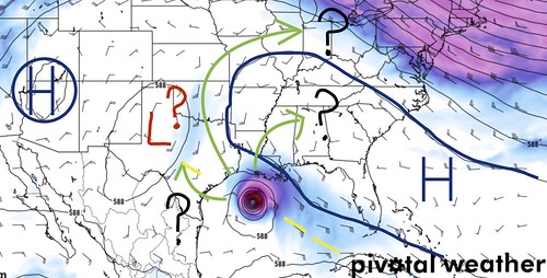
Because that Low may offer some insight into the final track for Laura – more so than even Marco. Laura will be seeking the easiest route to get to the North Pole, due to the Coriolis Effect. So a little area of low pressure that develops between the ridge to the west and the ridge to the east would provide a bit of weakness between the ridges to allow Laura to sneak through.
But the placement of the Low, the strength, etc would be information key to figuring out if it will change anything with Laura. And if so, how much.
Whereis the low-level center of Laura?
This is something that has been tough to track of the last 18 hours. Hurricane Hunters are doing there best to use their instrumentation to find it when they fly through, but due to land interaction, the center of the storm becomes very, very important.
If the center stays out over water on the south side of the islands it should help the storm continue to organize. If it stays out over the water on the north side of the islands, it would continue to maintain its strength, but would likely be beat up a bit more. If the center moved through the islands and over land, it would beat it up even more.
So figuring out where the center is becomes important to forecasting and short-term strengthening.
The Bottom Line
Tropical forecasts are always tricky. There is a chance the forecast will change. In fact, it will likely change. So, like always, I’ll ask that you – Please! – keep tabs on the forecast.
But check your Hurricane Preparedness Kit now. Check your Hurricane Plan now. Do you have enough supplies to last a few days without power or water? Do you have enough medicine to get you through? Are all of the shrubs and trees trimmed near your house? Can heavy rain get moved away from your home to reduce the risk of flooding?
Prepare your home now for the potential. If nothing happens? Great! You were prepared. But you don’t want to be caught unprepared if something does happen.


