Really, on any other year, it would be the opposite. Marco, moving through the central gulf would be “cruising easy” and Laura would be the one getting “beat up” by the mountains of Cuba.
But it is 2020. So nothing makes sense.
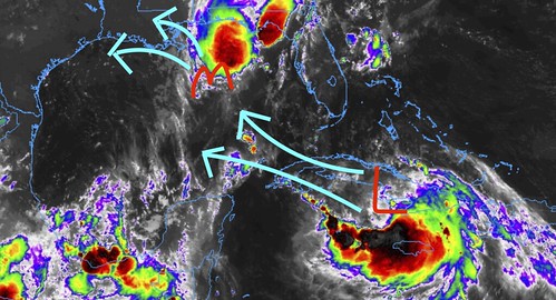
As Marco nears the central Gulf Coast, it is getting torn apart by wind shear. As Laura moves by Cuba, it seems unfazed by the interaction with any landmass.
Quick Forecast
As Marco moves toward the coast, the wind shear will continue to make it tough for the system to stay organized. The mid-level and upper-level wind will continue to scrape any storms that develop to the NE as the lower-levels of the storm are pushed to the NW.
Here is the latest from the NHC on Marco:

Marco will make landfall some time during the day on Monday along the Louisiana cast.
Laura will continue to cruise past Cuba with – likely – little interference from land. While that is normally not the case, this system seems to be unaffected by the land interaction thus far in the Caribbean.
Here is the latest from the NHC on Laura:

Laura will make landfall – based on the latest available data – some time on Wednesday along the Louisiana coast.
Recapping a previous point
I mentioned previously that the faster Marco kicked the bucket, the more troublesome the forecast may become for Laura. That still holds true. The forecast for Laura has been based on Fujiwhara complications, upper-ridging responses to a second system, and other subtle impacts from a nearby tropical system.
Sadly, without the second system there, it doesn’t instantly make Laura’s forecast easier to predict. I makes it more complicated, if difficult. Because all of the previous markers used to indicate Laura’s path are in the process of changing. Or being removed completely.
That doesn’t mean the forecast will need to be blown up and started from scratch, but it does mean that some more shifts in the cone may occur during the next 24 hours. Especially if Laura’s interaction with Cuba is more disruptive than when it passed by Hispaniola.
South Mississippi impacts
As it moves shore it will producer heavy rain, gusty wind and the potential for a few brief tropical tornadoes will be the name of the game between 10am and 10pm. Some of the potential threats – like heavy rain and tropical tornadoes – may linger through the overnight hours. Flash flooding is a concern, but there is still some question about how much rain Marco will actually produce for the area. The flooding potential will depend on the location of the heaviest rainbands, and that is an unknown at this point. But up to 6 inches of rain – or more – will be possible for some spots.
For most of the area, this will not be a dramatic event. Heavy rain at times and wind gusts up to 35mph will be likely. And the chances for stronger wind and heavier rain will increase the closer you get to the coast. Places like Laurel and Hattiesburg may not see wind gusts higher than 50mph. Places like Poplarville and Wiggins may see gusts as high as 60mph.
Beyond that, as Laura passes by the the south, it currently looks like any impacts the area receives from Laura will be secondary to landfall. So after it moves ashore, the rainbands may push through increase the chance for more heavy rain and gusty wind.
Historically Speaking
If Marco can hold itself together and Laura can get into the Gulf quick enough, it would be the third time on record that two tropcial storms occupied the Gulf simultaneously.
That said, given Marco’s struggles, it may not last very long if it happens.


