Tropical Storm Ida is now taking shape and is forecast to become a near Major Hurricane in the Gulf before landfall along the Louisiana coast on Sunday night.
Here is the latest information from the National Hurricane Center
Latest Observations
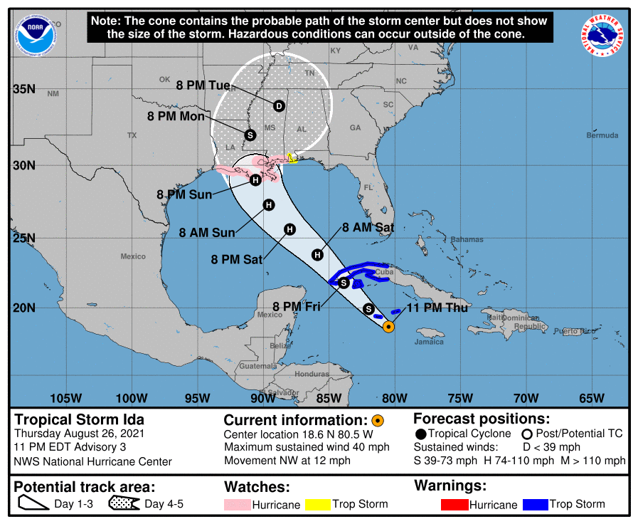
LOCATION…18.6N 80.5W
ABOUT 65 MI…105 KM SE OF GRAND CAYMAN
ABOUT 365 MI…585 KM SE OF THE WESTERN TIP OF CUBA
MAXIMUM SUSTAINED WINDS…40 MPH…65 KM/H
PRESENT MOVEMENT…NW OR 320 DEGREES AT 12 MPH…19 KM/H
MINIMUM CENTRAL PRESSURE…1006 MB…29.71 INCHES
Key Messages
- Tropical storm conditions are expected in portions of the Cayman Islands tonight and in portions of western Cuba and the Isle of Youth Friday, where a dangerous storm surge is also possible in areas of onshore flow. Life-threatening heavy rains, flash flooding and mudslides are expected across Jamaica, the Cayman Islands, and western Cuba, including the Isle of Youth.
- There is an increasing risk of life-threatening storm surge inundation along the coasts of Louisiana, Mississippi, and Alabama, where a Storm Surge Watch is in effect. Interests in these areas should follow any advice given by local officials.
- There is an increasing risk of dangerous hurricane-force winds beginning Sunday along the portions of the coasts of Louisiana and Mississippi, including metropolitan New Orleans, where a Hurricane Watch is in effect.
- Ida is likely to produce heavy rainfall Sunday into Monday along the central Gulf coast resulting in flash, urban, small stream, and riverine flooding.
Forecast position & wind speeds
INIT 27/0300Z 18.6N 80.5W 35 KT 40 MPH
12H 27/1200Z 19.9N 82.0W 45 KT 50 MPH
24H 28/0000Z 21.8N 83.9W 55 KT 65 MPH…NEAR CUBA
36H 28/1200Z 23.8N 85.9W 65 KT 75 MPH
48H 29/0000Z 25.6N 88.0W 75 KT 85 MPH
60H 29/1200Z 27.3N 89.6W 85 KT 100 MPH
72H 30/0000Z 29.0N 90.6W 95 KT 110 MPH…NEAR THE COAST
96H 31/0000Z 32.0N 91.0W 45 KT 50 MPH…INLAND
120H 01/0000Z 33.9N 88.8W 25 KT 30 MPH…INLAND
Greatest Concerns
STORM SURGE: A dangerous storm surge will raise water levels by as much as 2 to 4 feet above normal tide levels in areas of onshore winds along the immediate coast of the Isle of Youth and near and to the east of where the center crosses the coast of western Cuba. Near the coast, the surge will be accompanied by large and destructive waves.
The combination of a dangerous storm surge and the tide will cause normally dry areas near the coast to be flooded by rising waters moving inland from the shoreline. The water could reach the following heights above ground somewhere in the indicated areas if the peak surge occurs at the time of high tide.

Morgan City, LA to Ocean Springs, MS including Lake Borgne…7-11 ft
Rockefeller Wildlife Refuge, LA to Morgan City, LA including
Vermilion Bay…4-7 ft
Ocean Springs, MS to MS/AL border…4-7 ft
MS/AL border to AL/FL border including Mobile Bay…3-5 ft
Lake Pontchartrain…3-5 ft
Lake Maurepas…2-4 ft
Sabine Pass to Rockefeller Wildlife Refuge, LA…2-4 ft
The deepest water will occur along the immediate coast near and to the east of the landfall location, where the surge will be accompanied by large and dangerous waves. Surge-related flooding depends on the relative timing of the surge and the tidal cycle, and can vary greatly over short distances. For information specific to your area, please see products issued by your local National Weather Service forecast office.
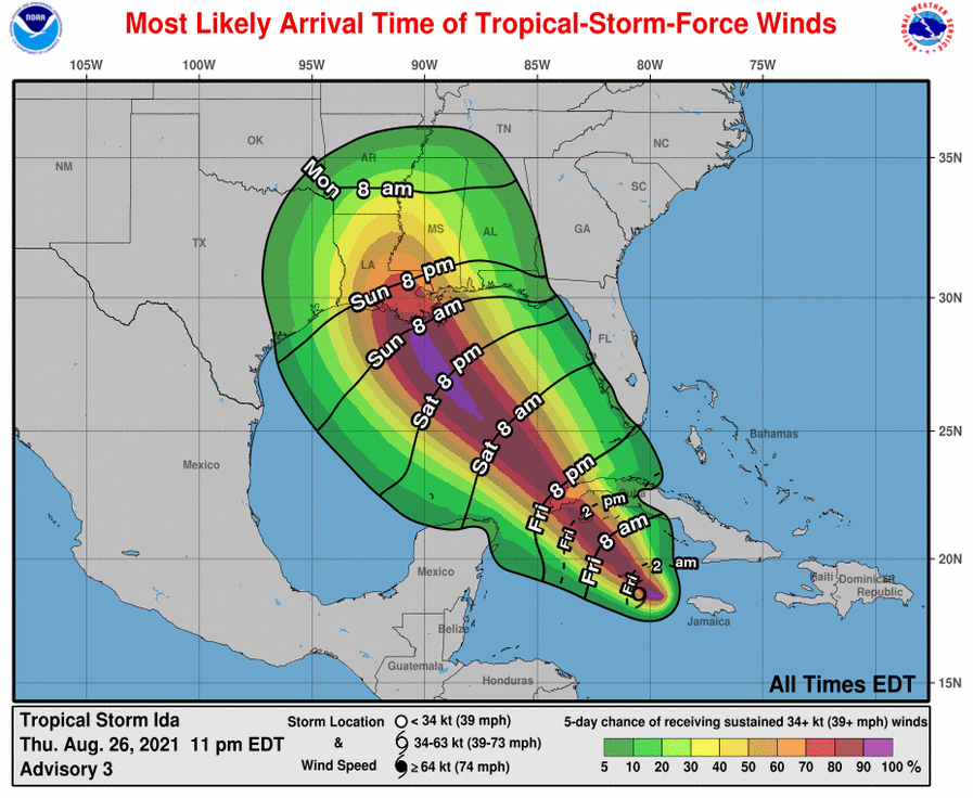
WIND: Tropical storm conditions are expected in the Cayman Islands tonight, and are expected to reach the Isle of Youth and portions of western Cuba in the warning area on Friday. Hurricane conditions are possible in the hurricane watch area along the northern Gulf coast late Saturday night or Sunday and tropical storm conditions are possible in the watch area late Saturday night or Sunday.
RAINFALL: Tropical Storm Ida is expected to produce total rainfall accumulations of 6 to 10 inches with maximum totals of 15 inches across Jamaica. Rainfall totals of 8 to 12 inches with isolated maximum amounts of 20 inches are expected across the Cayman Islands and western Cuba, including the Isle of Youth. These rainfall amounts may produce life-threatening flash floods and mudslides.

Tropical Storm Ida is likely to bring rainfall amounts of 8 to 12 inches with isolated maximum amounts up to 15 inches along the central Gulf Coast Sunday into Monday. This is likely to result in flash, urban, small stream, and riverine flooding to the central Gulf Coast.
SURF: Swells generated by this system will affect Jamaica, the Cayman Islands and Cuba tonight and Friday. Swells will begin reaching portions of the northern Gulf coast Saturday night or early Sunday. These swells are likely to cause life-threatening surf and rip current conditions. Please consult products from your local weather office.
WATCHES AND WARNINGS
CHANGES WITH THIS ADVISORY:
The Storm Surge Watch has been issued from Sabine Pass to the Alabama/Florida border including Vermilion Bay, Lake Borgne, Lake Pontchartrain, Lake Maurepas, and Mobile Bay
A Hurricane Watch has been issued from Cameron, Louisiana eastward to the Mississippi/Alabama border, including Lake Pontchartrain, Lake Maurepas, and metropolitan New Orleans.
A Tropical Storm Watch has been issued from the Mississippi/Alabama border to the Alabama/Florida border.

SUMMARY OF WATCHES AND WARNINGS IN EFFECT:
A Storm Surge Watch is in effect for…
- Sabine Pass to Alabama/Florida border
- Vermilion Bay, Lake Borgne, Lake Pontchartrain, Lake Maurepas, and Mobile Bay
A Hurricane Watch is in effect for…
- Cameron, Louisiana to the Mississippi/Alabama border
- Lake Pontchartrain, Lake Maurepas, and Metropolitan New Orleans
A Tropical Storm Warning is in effect for…
- Cayman Islands
- Cuban provinces of Matanzas, Mayabeque, Havana, Artemisa, Pinar del Rio, and the Isle of Youth
A Tropical Storm Watch is in effect for…
- Mississippi/Alabama border to the Alabama/Florida border.
A Storm Surge Watch means there is a possibility of life-threatening inundation, from rising water moving inland from the coastline, in the indicated locations during the next 48 hours. For a depiction of areas at risk, please see the National Weather Service Storm Surge Watch/Warning Graphic, available at hurricanes.gov.
A Hurricane Watch means that hurricane conditions are possible within the watch area. A watch is typically issued 48 hours before the anticipated first occurrence of tropical-storm-force winds, conditions that make outside preparations difficult or dangerous.
A Tropical Storm Warning means that tropical storm conditions are expected somewhere within the warning area within 36 hours.
A Tropical Storm Watch means that tropical storm conditions are possible within the watch area, generally within 48 hours.
Interests elsewhere in central and western Cuba, in the northern Yucatan Peninsula, and elsewhere along the northern U.S. Gulf coast should monitor the progress of this system.
For storm information specific to your area in the United States, including possible inland watches and warnings, please monitor products issued by your local National Weather Service forecast office. For storm information specific to your area outside of the United States, please monitor products issued by your national meteorological service.
Brief Discussion & Outlook
At 1100 PM EDT (0300 UTC), the center of Tropical Storm Ida was located near latitude 18.6 North, longitude 80.5 West. Ida is moving toward the northwest near 12 mph (26 km/h) and this general motion should continue over the next few days. On the forecast track, the center of Ida will pass near or over the Cayman Islands during the next few hours, the Isle of Youth and western Cuba Friday, and over the southeastern and central Gulf of Mexico Friday night and Saturday. The system is forecast to approach the U.S. northern Gulf coast on Sunday.
Maximum sustained winds are near 40 mph (65 km/h) with higher gusts. Ida is forecast to become a hurricane over the southeastern Gulf of Mexico in a day or two with additional strengthening expected thereafter. Ida could be near major hurricane strength when it approaches the northern Gulf coast.
Tropical-storm-force winds extend outward up to 70 miles (110 km) from the center.
The estimated minimum central pressure is 1006 mb (29.71 inches).
NHC Technical Discussion
The Air Force Hurricane Hunters have been investigating Ida this evening and found maximum flight-level winds of 47 kt at 2500 ft. This data along with numerous unflagged 35-kt SFMR winds supported raising the intensity to 35 kt earlier this evening. Since the aircraft departed Ida, there has been little change in the storm’s structure, so the initial intensity was held at 35 kt.
Ida is an asymmetric tropical storm with most of the deep convection and stronger winds confined to the eastern half of the circulation. Both the NOAA and Air Force Hurricane Hunters will be investigating Ida Friday morning.
The storm has been wobbling around, but smoothing through the recent erratic motion yields an initial motion estimate of 320/10 kt. A mid-level ridge centered off the southeast U.S. coast is expected to shift westward on Friday and over the weekend. This feature should keep Ida moving on a general northwestward track for the next 2 or 3 days, taking the core of the system over western Cuba Friday afternoon or evening and then across the southern and central Gulf of Mexico this weekend.
Although some model timing differences remain, they are in fairly good agreement that Ida will make landfall in Louisiana late Sunday or early Monday. The GFS and ECMWF ensemble members basically span a similar region and are most concentrated across the state of Louisiana. Users are reminded to not focus on the exact forecast track as impacts will extend far from the center and the average 72-hour track error is around 120 miles.
There is some southwesterly vertical wind shear affecting Ida at the moment, which is the likely part of the reason the cloud pattern and wind field are asymmetric. However, the global model show the upper-level pattern becoming quite favorable late Friday and through the weekend. These more conducive winds aloft combined with very warm SSTs and abundant moisture is likely to result in steady or rapid intensification until Ida makes landfall in the U.S.
The intensity guidance unanimously show Ida becoming a hurricane, but there is notable spread in how strong the system will become. Given the expected favorable environmental conditions for the storm, the NHC intensity forecast lies near the high end of the model guidance, in best agreement with the regional hurricane models. It is also worth noting that even though the global models are not particularly accurate in predicting tropical cyclone winds, the GFS and ECMWF show the minimum pressure falling more than 35 mb from the current conditions.
Based on all of this information, there is higher-than-normal confidence that a significant hurricane will be approaching the Gulf coast late this weekend.


I am so glad you are still out there giving us information on these tropical systems. Thank you Nick for taking time to keep up with us.