Ida is still moving northwest and there were only minor changes to the forecast overnight with the eventual landfall of Ida along the Louisiana coast. Here is the latest on Tropical Storm Ida:
Brief NHC Discussion
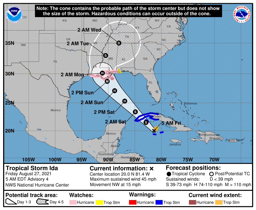
At 500 AM EDT (0900 UTC), the center of Tropical Storm Ida was located by weather radar on Grand Cayman near latitude 20.0 North, longitude 81.4 West. Ida is moving toward the northwest near 15 mph (24 km/h) and this general motion should continue over the next few days. On the forecast track, the center of Ida will move away from the Cayman Islands this morning, pass near or over the Isle of Youth and western Cuba later today, and over the southeastern and central Gulf of Mexico tonight and Saturday. The system is forecast to approach the U.S. northern Gulf coast on Sunday.
Maximum sustained winds have increased to near 45 mph (75 km/h) with higher gusts, and additional steady to rapid strengthening is expected during the next few days. Ida is forecast to become a hurricane over the southeastern Gulf of Mexico in a day or two, and to be at or near major hurricane strength when it approaches the northern Gulf coast.
Tropical-storm-force winds extend outward up to 80 miles (130 km) from the center.
The estimated minimum central pressure is 1001 mb (29.56 inches). Grand Cayman Island recently reported a pressure of 1003 mb (29.62 inches).
Main concerns
STORM SURGE: A dangerous storm surge will raise water levels by as much as 2 to 4 feet above normal tide levels in areas of onshore winds along the immediate coast of the Isle of Youth and near and to the east of where the center crosses the coast of western Cuba. Near the coast, the surge will be accompanied by large and destructive waves.
The combination of a dangerous storm surge and the tide will cause normally dry areas near the coast to be flooded by rising waters moving inland from the shoreline. The water could reach the following heights above ground somewhere in the indicated areas if the peak surge occurs at the time of high tide…
Morgan City, LA to Ocean Springs, MS including Lake Borgne…7-11 ft
Rockefeller Wildlife Refuge, LA to Morgan City, LA including
Vermilion Bay…4-7 ft
Ocean Springs, MS to MS/AL border…4-7 ft
MS/AL border to AL/FL border including Mobile Bay…3-5 ft
Lake Pontchartrain…3-5 ft
Lake Maurepas…2-4 ft
Sabine Pass to Rockefeller Wildlife Refuge, LA…2-4 ft
The deepest water will occur along the immediate coast near and to the east of the landfall location, where the surge will be accompanied by large and dangerous waves. Surge-related flooding depends on the relative timing of the surge and the tidal cycle, and can vary greatly over short distances. For information specific to your area, please see products issued by your local National Weather Service forecast office.
WIND: Tropical storm conditions are expected in the Cayman Islands this morning, and are expected to reach the Isle of Youth and portions of western Cuba in the warning area later today. Hurricane conditions are possible in the hurricane watch area along the northern Gulf coast late Saturday night or Sunday and tropical storm conditions are possible in the watch area late Saturday night or Sunday.
RAINFALL: Ida is expected to produce total rainfall accumulations of 6 to 10 inches with maximum totals of 15 inches across Jamaica. Rainfall totals of 8 to 12 inches with isolated maximum amounts of 20 inches are expected across the Cayman Islands and western Cuba, including the Isle of Youth. These rainfall amounts may produce life-threatening flash floods and mudslides.

As Ida approaches the central Gulf Coast Sunday afternoon, total rainfall accumulations of 8 to 16 inches with isolated maximum amounts of 20 inches are possible from southeast Louisiana to coastal Mississippi and Alabama through Monday morning. Ida is forecast to turn northeast as it moves inland later Monday with rainfall totals of 4 to 8 inches possible across southern and central Mississippi. This is likely to result in considerable flash, urban, small stream, and riverine flooding.
SURF: Swells generated by this system will affect Jamaica, the Cayman Islands and Cuba tonight and Friday. Swells will begin reaching portions of the northern Gulf coast Saturday night or early Sunday. These swells are likely to cause life-threatening surf and rip current conditions. Please consult products from your local weather office.


Thank you so much Nick…