The evening model data is starting to trickle in for Tropical Depression 10. And while the official forecast from the NHC is mostly unchanged, there are some places that I think will change in the coming days.
[wpcode id=”41149″]
THE LATEST FROM THE NHC

DISCUSSION AND OUTLOOK
At 1000 PM CDT (0300 UTC), the center of Tropical Depression Ten was located near latitude 21.1 North, longitude 86.4 West. The depression is drifting toward the southwest near 2 mph (4 km/h) and is likely to meander near the Yucatan Channel through early Monday. A faster motion toward the north or north-northeast is expected on Monday, bringing the system over the eastern Gulf of Mexico.
Maximum sustained winds are near 35 mph (55 km/h) with higher gusts. Additional strengthening is forecast during the next few days. The depression is expected to become a tropical storm on Sunday and a hurricane by Tuesday.
The estimated minimum central pressure is 1005 mb (29.68 inches).
TECHNICAL DISCUSSION
Images from the Mexico meteorological service’s radar in Cancun show that the depression has a small but well-defined circulation with spiral banding extending no more than about 60 n mi from the center. This feature is embedded within a larger circulation with scattered deep convection covering the northwestern Caribbean Sea, extreme southeastern Gulf of Mexico, and adjacent land areas. The initial intensity is set to 30 kt based on the latest subjective Dvorak estimate from TAFB and objective numbers from UW-CIMSS.
The depression appears to be drifting toward the southwest with an initial motion of 230/2 kt, with low- to mid-level ridging located to its north and northwest. The system is expected to continue meandering over the northwestern Caribbean Sea for the next 24-36 hours. After that time, a developing trough over the Gulf of Mexico and strengthening ridging over the western Atlantic is expected to begin lifting the system toward the north and north-northeast over the eastern Gulf of Mexico toward Florida, and then near the southeastern coast of the U.S. The updated NHC track forecast lies on top of or very near the previous prediction and closely follows the TVCX and HCCA consensus aids.
Assuming the depression’s center does not move over the Yucatan Peninsula, very warm waters and low to moderate vertical shear should support gradual strengthening during the next few days. The NHC intensity prediction is a little below the consensus aids during the first 36 hours of the forecast but then converges with those aids thereafter, showing the system reaching hurricane strength by 60 hours. The system is expected to remain a hurricane, and potentially continue strengthening, up until it reaches the Gulf coast of Florida on Wednesday. Users are reminded to continue monitoring forecasts for any changes to the system’s expected intensity as it approaches Florida. Land interaction and increasing shear should lead to fast weakening after the system moves over land, but it could still produce tropical-storm-force winds near and offshore the southeastern coast of the U.S. even if the center is
KEY MESSAGES:
- Heavy rainfall from Tropical Depression Ten is expected across the eastern Yucatan Peninsula and western Cuba. The heavy rainfall may produce areas of flash and urban flooding, as well as landslides, across western Cuba. The depression is forecast to become a tropical storm by Sunday, and tropical storm conditions are expected over portions of the Yucatan Peninsula where a Tropical Storm Warning is in effect. Tropical storm conditions are possible over portions of western Cuba within the Tropical Storm Watch area.
- The depression is forecast to strengthen during the next few days and could become a hurricane over the eastern Gulf of Mexico, bringing a potential of dangerous storm surge, heavy rainfall, and strong winds to portions of the west coast of Florida and the Florida Panhandle by the middle of next week. Heavy rainfall is also likely to spread into portions of the Southeast U.S. by mid to late next week. Although it is too soon to specify the exact location and magnitude of these impacts, residents in these areas should monitor updates to the forecast of this system and ensure that they have their hurricane plan in place.
FORECAST POSITIONS AND MAX WINDS
INIT 27/0300Z 21.1N 86.4W 30 KT 35 MPH
12H 27/1200Z 20.9N 86.4W 35 KT 40 MPH
24H 28/0000Z 20.9N 86.2W 40 KT 45 MPH
36H 28/1200Z 21.6N 85.9W 45 KT 50 MPH
48H 29/0000Z 23.1N 85.7W 55 KT 65 MPH
60H 29/1200Z 25.0N 85.5W 65 KT 75 MPH
72H 30/0000Z 27.5N 84.8W 70 KT 80 MPH
96H 31/0000Z 32.7N 81.5W 45 KT 50 MPH…INLAND
120H 01/0000Z 35.2N 76.7W 35 KT 40 MPH…INLAND
[wpcode id=”41149″]
MODEL GUIDANCE
Now that we have a center on this thing and have had 12 hours of satellite data to ingest into the model guidance, I think we are starting to see some of the models coming into better agreement with each other (not that there was any kind of crazy disagreement) and with themselves.
The track has shifted slightly west during the day today, but is still looking like the Big Bend region of Florida for the landfall of the center. This is shown in most of the model guidance specific to tropical systems as well as the global ensemble guidance.


The one thing that has changed is the intensity forecast. Originally, many models had this as a Tropical Storm or Category 1 Hurricane, where now many models show it as a Category 1 Hurricane with a small group showing tropical storm and two models suggesting a Category 2 Hurricane at landfall.

The other things to monitor is the SHIPS guidance which is used to specifically forecast the potential intensity of the system.
The SHIPS forecast attempts to discern the potential for Rapid Intensification. As well as the ‘ceiling for said intensification.

This storm shows at least a 1.8-times and up to a 5.6-times greater-than-climatology chance to see some sort of Intensification as well as a 5.6-times higher-than-climatology chance that it strengthens 65kts during the next 72 hours. .
If that happened, it would be a Category 2 Hurricane.
[wpcode id=”41149″]
GULF WATER TEMPERATURES
Warm. Really warm. I will say this, though, not as warm as I anticipated.


The depth of the 26C isotherm is 50m where it turns from darker blue to that lighter blue shading when looking at the image on the left. That is enough to sustain a Major Hurricane. It only gets deeper when you get to yellows and reds. So, there is plenty of food for this thing to eat.
Looking at the map on the right, the TCHP map shows plenty of yellows, oranges and reds along the path of TD 10 to the north.Another good indicator that we have enough food to feed a Major Hurricane.
But while we can ‘sustain’ a Major Hurricane, it doesn’t mean that this will necessarily ‘make’ a Major Hurricane. For that we need more than just warm waters. That takes the combination of warm waters and a friendly atmosphere.
And we should have a pretty friendly atmosphere during the next 72 hours, according to model guidance.
So buckle up.
[wpcode id=”41149″]
WHO NEEDS TO CARE
If you are living anywhere from Mobile, Alabama east to Jacksonville, Florida and anywhere down the spine of the Florida peninsula, you need to care. If you live within 100 miles of the Gulf of Mexico east of Mobile, Alabama, you need to care.
Because I think the ‘best case scenario’ from TD10 is reflected in the forecasts from the WPC and NBM. The WPC suggests 2″ to 6″ of rain for parts of Florida with wind gusts up to 40mph.
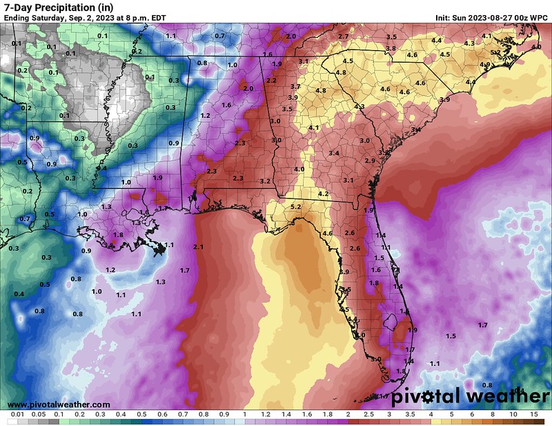

And that is the ‘best case scenario’ or, you can think of it as the most reasonable lowest impact event.
Which means it is only up from there.
[wpcode id=”41149″]
WHERE THIS FORECAST MAY CHANGE
I tend to think the intensity forecast will likely need to be increased. Perhaps even substantially. I think the data supports the potential for a Major Hurricane in the Gulf.
Furthermore, I think the forecast track will shift, too, though I’m uncertain as to where. I think if we base things on the interaction with the trough and the interaction with the ridging based on the speed of Franklin – we lean west. But, if we take into account the area of low pressure over Mississippi, maybe we lean more east.
That Low is basically invisible to the model guidance.
Looking at the 300mb map (up around 25,000ft) on the left, the EPS here can see the broad area of rotation. But down at the 500mb map (around 18,000ft) the model can’t see it at all.

And I can assure you it is there. The images below – from left to right – are the low-level, mid-level, and upper-level shots from the GOES-16 satellite. Clearing showing an area of low pressure swirling along the Mississippi Coast.

This would create a bit of a similar scenario that we had in California just a few weeks ago where an upper-level low and a tropical system would do a little jig where in Step 1 they would deflect and then in Step 2 they would re-curve back.

The amount of deflection and re-curve on the map above is exaggerated to highlight the movement, but you would have a bit of a wiggle one way and then back. It means we may see impacts across southern Florida and then impacts across the panhandle, too.
A lot of this will come into better focus as the Hurricane Hunters are able to fly into the storm and get precise data from inside and around Tropical Depression 10.
For now, please continue to check back for updates.
[wpcode id=”41149″]

