So, let me preface this with a plug to Nick’s tropical outlook. Since Invest 93 is beginning to organize, this will affect us later in the week in other ways than just rain and wind. What I mean is, will this system keep some of the heat away from us for a while?
The short answer is mostly yes. While it won’t be a massive change in temperature, it will still be slightly better than what we’ve been dealing with for the past month. Even though we’ve been in a lull for the past month, the midwest is slowly becoming more active with a few troughs pushing through the Great Lakes during the week and some weaker ones will likely reach our neck of the woods.
The Weekend
This weekend is going to be scorching. Plain and simple, nothing new going on. There may be isolated to possible scattered thunderstorms that could happen mainly on Sunday. Highs will be in the 100s and lows in the upper 70s. The massive ridge we’ve been under is starting to hit the road back west by Monday.
Monday and Tuesday

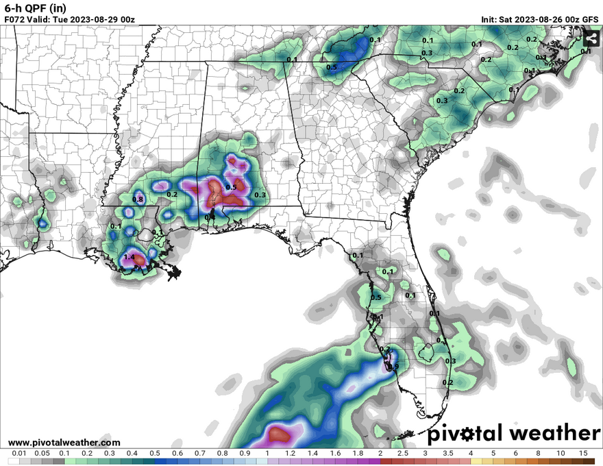
The large stationary front that is coming through during the weekend will remain over most of the South for a couple of days. With this, our largest chances for rain will also be on Monday and Tuesday. An upper-level shortwave that is moving in from the west will supply enough low pressure to give enough lift for some storms to develop. Even the SPC is putting a marginal risk for most of the Southeast with the rain and wind possible.

Wednesday into the Weekend
This is where things get a little hairy due to the possible tropical conundrum. Depending on where this Invest may turn, we may get some small shots of rain on Wednesday and Thursday. Temperatures will also pull down into the low 90s as it passes. Winds will pull mostly from the north and east until it moves out.
Closer to the weekend, we may see a few spotty showers. Winds will return back to their southerly flow as the high from the Midwest begins to take over which will leave us in a familiar southern summer pattern we haven’t seen in a while.
[wpcode id=”41179″]
Regional Day-to-Day Forecast
Today – A 20 percent chance of showers and thunderstorms in the mid-afternoon. Sunny and hot, with a high near 105. Heat index values as high as 109. Calm wind becoming north northwest around 5 mph in the morning.
Tonight – A slight chance of showers and thunderstorms before dusk. Mostly clear, with a low around 77. North northwest wind around 5 mph becoming calm in the evening. Chance of precipitation is 20%.
Sunday – A 40 percent chance of showers and thunderstorms after noon. Sunny and hot, with a high near 105. Heat index values as high as 110. Calm wind becoming north around 5 mph in the afternoon. New rainfall amounts of less than a tenth of an inch, except higher amounts possible in thunderstorms.
Sunday Night – A 30 percent chance of showers and thunderstorms before midnight. Partly cloudy, with a low around 75. East wind around 5 mph becoming calm in the evening.
Monday – Showers and thunderstorms, mainly after noon. High near 97. Calm wind becoming north northeast around 5 mph in the afternoon. Chance of precipitation is 80%. New rainfall amounts between a half and three quarters of an inch possible.
Monday Night – Showers and thunderstorms likely, mainly before midnight. Mostly cloudy, with a low around 73. North wind around 5 mph becoming calm in the evening. Chance of precipitation is 70%. New rainfall amounts between a quarter and half of an inch possible.
Tuesday – Showers and thunderstorms likely, mainly after noon. Mostly sunny, with a high near 89. Calm wind becoming east northeast around 5 mph in the afternoon. Chance of precipitation is 60%.
Tuesday Night – A 30 percent chance of showers and thunderstorms before midnight. Partly cloudy, with a low around 72. East wind around 5 mph becoming calm in the evening.
Wednesday – A 30 percent chance of showers and thunderstorms after noon. Mostly sunny, with a high near 90. Calm wind becoming north northeast around 5 mph in the afternoon.
Wednesday Night – A 20 percent chance of showers and thunderstorms before midnight. Mostly clear, with a low around 71.
Thursday – A 20 percent chance of rain and thunderstorms. Sunny, with a high near 93.
Thursday Night – Mostly clear, with a low around 72.
Friday – A 30 percent chance of showers and thunderstorms. Mostly sunny, with a high near 92.
[wpcode id=”41149″]


