Invest 93L had a bit of a ‘glow up’ (as the kids would say) overnight. Looking much healthier this morning than when you went to bed last night. Overnight latent heat release is one reason, the trough conditioning the atmosphere all day yesterday with afternoon storms is, likely, the other.

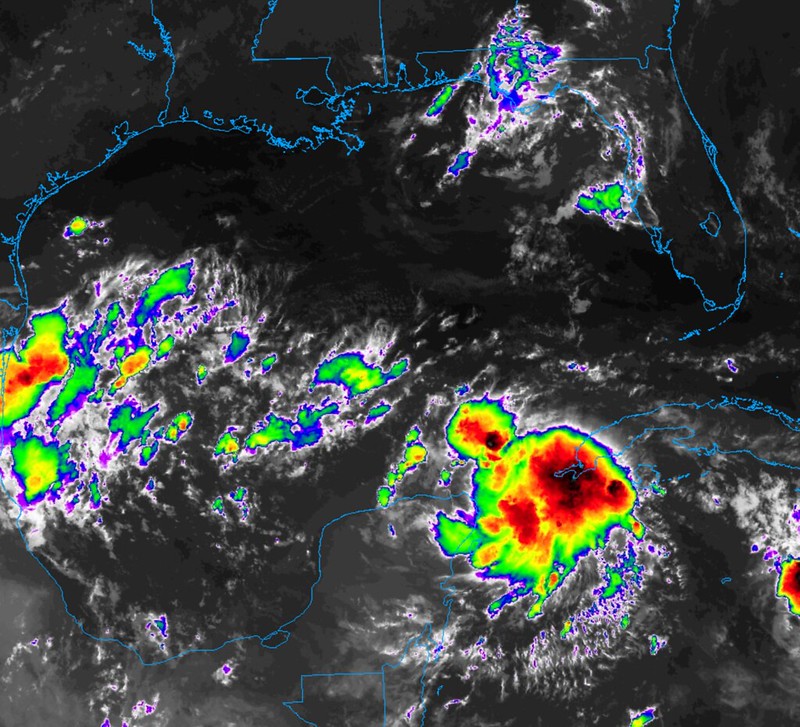
Notice the main difference is the single burst of convection this morning versus the disorganized mess last night.

A wider annotated view shows 93L sitting under an mid- and upper-level ridge (of sorts) and just south of a boundary between drier air from the north and the more moist air to the south. One interesting thing on the map is the shove of drier air toward the Gulf from the northeast. I don’t recall model guidance picking up on that. Also the two mid-level areas of lower pressure – on over southern Mississippi and the other over Mexico.
You can see how many moving parts there are to this system, already, and we haven’t even gotten into the forecast yet!
It remains to be seen if it can hold this convection through the day. Often we see these explosions of storms overnight and the following morning storms dissipate and fall apart. Unlike storms over land, the daytime sunshine isn’t *always* a good thing for developing thunderstorms over the open ocean.
What happens with Invest 93L depends on a few things. As we move through the next few days, it is a bit of a race between….
1 – how fast Invest 93L forms into a tropical storm or hurricane
2 – how fast Tropical Storm Franklin moves north
3 – how fast the ridge of high pressure builds back to the west in behind Franklin
4 – how fast the trough pass through
5 – how deep the trough gets into the south
[wpcode id=”41149″]
THE RIDGING
I want to start with Number 3 on the list above because I think it probably carries the most weight.
Let’s zoom forward in time. On the map below, from the Euro operational model, for Monday night you can see Franklin moving north, the ridge still to the east and 93L still off the coast of the Yucatan.

The neon arrows indicate the most likely path from Monday of next week through Thursday of next week. The dashed neon lines for Invest 93L are the difference between the potentially more northerly track and the potentially more southerly track. The black dashed line is the periphery of the ridging that helps to guide tropical systems. Though, it isn’t perfect — as you can see from Franklin, as tropical systems gain strength they can bully their way through that line — but it is a good start.
Notice how the southern side of that dashed line is much farther west than the northern part of that dashed line. That is due to Franklin.
If Franklin decides to move quicker, the northern side of that line will be farther west.
Right now, the thought is that the dashed line that guides Invest 93L will be slow to push back into the western Caribbean and Gulf, but even slower to push west the farther north you go up that line. That will limit how far north Invest 93L gets shoved before starting to move northeast.
But there is plenty of uncertainty there.
[wpcode id=”41149″]
FRANKLIN’S SPEED & THE TROUGH
I think the other big factor is going to be Tropical Storm Franklin’s forward speed, and connected to that, the trough that swoops across the Great Lakes and Northeast.
Not to be nit-picky or pedantic here, but I have seen a lot – like, too many – meteorologists talk about how “a cold front will come in and steer Invest 93L toward Florida.”
A cold front will not. A trough in the lower, middle and upper levels of the atmosphere will interact with Invest 93L as it moves north.
But even that is still a bit up in the air. Prepare to get nerdy!

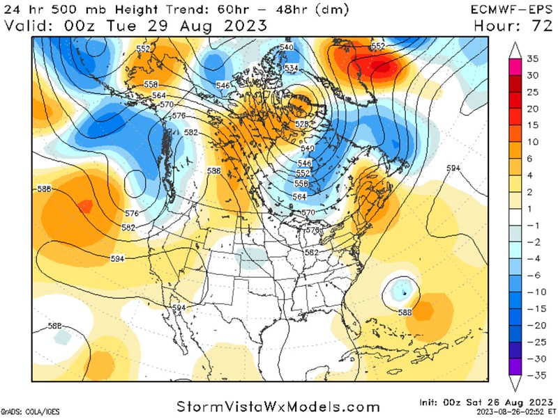


Maps Courtesy: StormVista Weather Models
Here is a look at the ensemble data looking at the 24 trends for the 500mb heights. The blue shaded areas are where the heights have gotten lower and the red is where heights have gotten higher.
What does that mean?
Well! We can use this as a measurement of which way the models are trending with troughs (lower heights), ridges (higher heights), and everything in-between.
Looking at the map on the left, which is 48 hours from now, the ensemble guidance is trending more west with Franklin and more general troughing in the Gulf. This means that the ridging in the Atlantic is farther west, too. That ridging is the thing that may push Invest 93L farther north.
(Check 1 for higher risk for more northerly track)
Looking at the map in the middle left, at 72 hours from now, the lower heights for Franklin are farther north – indicating the model things it will be moving north faster than 24 hours ago. It also shows slightly higher heights across Canada, the Great Lakes, and the Northeast. That suggests the incoming trough may be a bit slower to develop and slide south compared to what model guidance was thinking 24 hours ago. That trough is the thing that will guide Invest 93L to the northeast, rather than to the north.
(Check 2 for higher risk for more northerly track)
The middle right map, at 96 hours out (Tuesday night), shows the lower heights north of Franklin and higher heights south, another indication that Franklin is moving faster in today’s guidance versus yesterday’s guidance. We also see higher heights across the open Atlantic, Caribbean, and into Florida. On top of that, the troughing across the Great Lakes is deeper and the heights are higher to the west, indicating that the trough has sped up. In the Gulf there are lower heights farther west and along the northern Gulf Coast.
(Check 3 for higher risk of more northerly track)
The map on the right, at 120 hours out (five days, or Wednesday night), shows Invest 93L moving back out into the Atlantic, but with lower heights across Georgia and the Carolinas, indicating it is moving slower now compared to 24 hours ago. Slower movement can be used as a proxy for “it didn’t get impacted by the trough as much as before”
(Check 4 for higher risk of more northerly track)
So, we have many indicators here that the risk for a more northerly track is there. And quite real. So, despite what you may have heard elsewhere, I don’t think folks in Mississippi and Alabama can completely ignore this system quite yet. Louisiana, given today’s data, is still looking okay.
[wpcode id=”41149″]
INVEST 93L DEVELOPMENT
This is Number 1 on the list above for good reason. This is the thing that will dictate a lot of everything. If Invest 93L blossoms into a tropical depression today, and the center is well-defined, I think we will have a much better grasp on where it may go. The longer it sits and doesn’t really define a center, the longer we have to wait to know what will happen.
That is the big problem with these CAG-born systems. They are notoriously difficult to predict for this particular reason. They don’t start, form, and strengthen on the typical timescale that the African Waves do.
To make matters more complicated, we have already lost our CAG. So now we simply have some bubbling cumulus and thunderstorms near the Yucatan now disconnected to any particular forcing.

What does this mean? I couldn’t tell you, specifically. But I do think this will limit the potential that we see the center of the system form north of the Yucatan. So that’s good, because that would be a wicked curveball to the forecasts. I also think it will help this system get better organized a bit quicker.
That quicker development should limit the more northerly track risk. Should being the key word.
But given all of the moving parts in place, I think it would be foolish of me to sit here and say – with any certainty – that I know specifically what may happen.
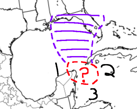
Instead, here is a map of the range of possibilities….
Timing of development being equal:
1 – A more northeasterly development means a higher risk of a more northerly track with a higher intensity storm
2 – A more easterly development means a higher risk for a more northeasterly track with not as high intensity
3 – A more southerly development means somewhere in the middle – or a complete wildcard
[wpcode id=”41149″]


One thought on “8/26/23 10a Tropical Update – Invest 93L still bubbling near Yucatan”
Comments are closed.