
Hey friends, I will attempt to be as thorough as possible as this may be my only post of the day, today.
As of latest update at 1PM, Hurricane Dorian was a Category 3 Hurricane. A Major Hurricane

SUMMARY OF 200 PM AST…1800 UTC…INFORMATION
———————————————-
LOCATION…24.8N 70.3W
ABOUT 445 MI…715 KM E OF THE NORTHWESTERN BAHAMAS
ABOUT 625 MI…1005 KM E OF WEST PALM BEACH FLORIDA
MAXIMUM SUSTAINED WINDS…115 MPH…185 KM/H
PRESENT MOVEMENT…NW OR 310 DEGREES AT 10 MPH…17 KM/H
MINIMUM CENTRAL PRESSURE…970 MB…28.64 INCHES
FORECAST POSITIONS AND MAX WINDS
INIT 30/1500Z 24.5N 69.8W 95 KT 110 MPH
12H 31/0000Z 25.3N 71.0W 105 KT 120 MPH
24H 31/1200Z 25.9N 72.7W 110 KT 125 MPH
36H 01/0000Z 26.3N 74.5W 115 KT 130 MPH
48H 01/1200Z 26.6N 76.1W 115 KT 130 MPH
72H 02/1200Z 26.8N 78.6W 120 KT 140 MPH
96H 03/1200Z 27.0N 80.4W 110 KT 125 MPH…INLAND
120H 04/1200Z 29.0N 81.5W 65 KT 75 MPH…INLAND
NHC Discussion
At 1100 AM AST (1500 UTC), the eye of Hurricane Dorian was locatednear latitude 24.5 North, longitude 69.8 West. Dorian is moving toward the northwest near 10 mph (17 km/h). A slower west-northwestward to westward motion should begin tonight and continue into early next week. On this track, the core of Dorian should move over the Atlantic well north of the southeastern and central Bahamas today and tomorrow, be near or over the northwestern Bahamas on Sunday, and be near the Florida peninsula late Monday.

Maximum sustained winds are near 110 mph (175 km/h) with higher gusts. Dorian is expected to become a major hurricane later today, and it will remain an extremely dangerous major hurricane while it moves near the northwestern Bahamas and approaches the Florida peninsula into early next week.
Hurricane-force winds extend outward up to 25 miles (35 km) from the center and tropical-storm-force winds extend outward up to 105 miles (165 km).
The estimated minimum central pressure from the NOAA and Air Force reconnaissance planes is 972 mb (28.71 inches).
NHC Detailed Discussion
Hurricane Dorian Discussion Number 25
NWS National Hurricane Center Miami FL AL052019
1100 AM AST Fri Aug 30 2019
Both Air Force and NOAA aircraft have been sending data from Dorian this morning. The flight-level winds from both planes have peaks at 100 kt and the SFMR measured 94 kt. The minimum central pressure has been oscillating between 972 and 976 mb. On this basis, the initial intensity has been set to 95 kt. The upper-low currently over Cuba which has been inducing some shear over Dorian is moving away from the hurricane, and the upper-level flow pattern is evolving toward a more favorable environment. In fact, the eye is becoming apparent on visible images as we speak and in radar data from the NOAA P3 aircraft. Consequently, the NHC forecast calls for additional intensification, and Dorian is expected to become an extremely dangerous major hurricane soon with additional strengthening likely as it heads for the northwestern Bahamas and the Florida peninsula.

Fixes from both reconnaissance planes indicate that Dorian is moving toward the northwest of 310 degrees at 9 kt. As the upper-low over Cuba moves westward and a strong subtropical ridge builds over the western Atlantic as indicated by global models, the hurricane should be forced to turn west-northwestward and westward on a track toward the northwestern Bahamas and the Florida peninsula. By the end of
the forecast period, the ridge is forecast to erode and the steering currents will weaken, resulting in Dorian slowing down considerably near and over the Florida peninsula. This increases the uncertainty in the track forecast during the 4- to -5 day period, and also will lead to a prolonged duration of wind, storm surge, and rainfall. The official forecast has been very consistent so far, and this one is very similar to the previous NHC forecast. It follows the multi-model and corrected consensus, and is in the middle of the guidance envelope.
Key Messages
1. Life-threatening storm surge and devastating hurricane-force
winds are likely in portions of the northwestern Bahamas, where a
hurricane watch is in effect. Residents should execute their
hurricane plan and listen to advice given by local emergency
officials.
2. Life-threatening storm surge and devastating hurricane-force winds are likely along portions of the Florida east coast by early next week, but it is too soon to determine where the highest storm surge and winds will occur. Residents should have their hurricane plan in place, know if they are in a hurricane evacuation zone, and listen to advice given by local emergency officials.
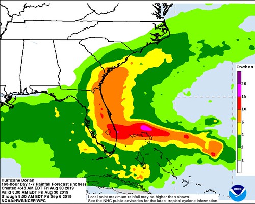
3. A prolonged period of storm surge, high winds and rainfall is likely in portions of Florida into next week, including the possibility of hurricane-force winds over inland portions of the Florida peninsula.
4. Heavy rains are expected over portions of the Bahamas, Florida, and elsewhere in the southeastern United States this weekend into the middle of next week.
Model Data & Local Discussion
The model data continues to line up with what the National Hurricane Center is forecasting. Unlike earlier in Dorian’s life, the model data is starting to come into better agreement and the storm is going in a direction – and gaining strength – in a reasonably predictable manner.
That’s not to say this forecast is a “lock” by any means, but it is a good sign that things are starting to play out a little more ‘as expected’ than previously.
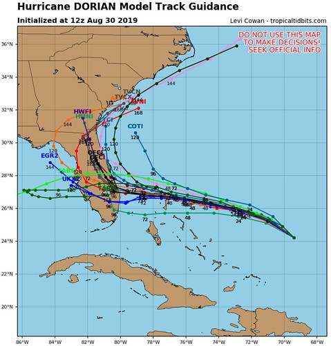
The spaghetti models are pretty sold on a Central / Southern Florida landfall. The model data through 72 hours is pretty consistent to put the storm just off the coast of Florida, but where landfall occurs is still a bit undetermined (more on that later).

The guidance for the storm through 72 hours is also pretty consistent within a range. Model data has Dorian between a Category 3 and Category 4 Hurricane through the next 72 hours.
And this model data lines up with the NHC forecast at the top of the post. So there is a lot of agreement between the model data and the forecast.
What we don’t know, yet
There is probably a lot. But there are a few big ones…
Specifically, where landfall will occur
We can’t know this until – at the soonest – 12 hours out. And even then, figuring out specifically where it will happen isn’t a slam dunk. Tropical systems tend to wobble around a bit when they move, and that wobbling can change the last minute landfall spot from one town to the next.
The ‘good’ news? For now, it doesn’t really matter. Sure, the ‘who got it worst’ argument will be had later, but for now, if you are in thw path of this storm, you need to be preparing like it is headed toward you.
Specifically, when it will turn north
We can’t know this either. We can give a range of possibilities (a lot like potential landfall) but spot-location specifics for weather forecasting are rarely ever accurate. In general, sadly, that just isn’t how the science works.
Will it get into the Gulf?
Because we don’t know, specifically, when Dorian will turn north, we also don’t know if it will get into the Gulf.
THAT SAID!
The ‘getting into the Gulf’ answer may be a technicality, more than something worth worrying about.
Model data shows a sharp turn north, at some point, as it approach, or crosses over, Florida. So, sure, Dorian may get back over the Gulf waters, but at that point, it may be moving north up, say the west coast for Florida (because it is in the cone, it is a possibility). So technically, yes, the forecast is for it to potentially be int eh Gulf of Mexico… but at that point in the forecast it is moving north.
Yeah, but what about Katrina
I know, that one was supposed to go north, too.
There are many major differences between this one and Katrina. At this location, Katrina was still a Tropical Wave with no discernible center for the forecast models to grab a hold of to forecast.
You can read more about how the forecast track for Hurricane Katrina was reasonably accurate here.
Suffice it to say that forecasts, like most things, over the last 14 years have gotten a lot better.
Remember Hurricane Irma in 2017.

It was forecast to do a similar turn north and everyone kept arguing that Katrina didn’t turn north, so this one wouldn’t either. Yet it did. As forecast.
Hurricane Matthew in 2016. Same thing.

as forecast, it pulled a hard turn north. It happens. And more often than not, it is correctly forecast.
That isn’t to say there is zero chance it continues into the Gulf. But it is also okay to trust the NHC when they put out a forecast. And you can trust that they will also give as much advanced warning as possible if there is a shift in the forecast track.
What Could Change? And Why
Beyond 72 hours, the track is still a bit up in the air. As is the intensity. The reason is the ridge that is building over the area now, may ease back tot he east through the next 72 hours. That is what opens the door, so to speak, to allow Dorian to move north.
There isn’t a front moving into the area to pull Dorian out. It is more so that there is an alleyway that opens up to allow Dorian to move north.

Notice that right now (graphic on the far right) there is a ridge blocking Dorian’s path north all the way across the Southeast.
But in 24 hours (bottom left graphic), that ridge starts to break down, allowing Dorian to now move north once it enters the Gulf of Mexico.
But notice in the next graphic (top left) that the ridge breaks down and pulls north and it allows Dorian to move north.
So, we are waiting to see how fast that ridge breaks down. The sooner it breaks down, the faster/sooner Dorian moves north. The longer the ridge lingers, the further west Dorian makes it.
And at this point, we can’t know for certain when exactly that will happen. All we know is that it will happen sometime between Sunday and Tuesday.
What parts of the forecast that are a total lock?
None. This forecast is likely to change. Sadly, with tropical systems nothing is ever truly ‘locked in’ which is why we always encourage you to follow the forecast with these systems closely. It is also why we try our best to kick out new forecasts as much as possible.
The Bottom Line
If you live in Florida
Prepare for one category higher than the forecast. The forecast is currently for a Category 4 Hurricane to make landfall. Prepare for a Category 5.
For more information about preparing for a hurricane, head to Ready.Gov
If you live along the northern Gulf Coast
So for now, check your Hurricane Preparedness Kit, check your supplies, make sure you have a plan. Double-check your insurance coverage, make sure you don’t have trees with loose branches or dead limbs around or near the house, and check nearby storm drains. But outside of that, just hang tight!
If you live up the East Coast
As Dorian shifts north, eventually it may become an issue along the East Coast. Be sure you are keeping tabs on this system and where it is headed.


