Here is a quick look at Hurricane Dorian

SUMMARY OF 800 AM EDT…1200 UTC…INFORMATION
———————————————-
LOCATION…25.8N 73.0W
ABOUT 445 MI…715 KM E OF WEST PALM BEACH FLORIDA
ABOUT 280 MI…450 KM E OF THE NORTHWESTERN BAHAMAS
MAXIMUM SUSTAINED WINDS…145 MPH…230 KM/H
PRESENT MOVEMENT…W OR 280 DEGREES AT 12 MPH…19 KM/H
MINIMUM CENTRAL PRESSURE…944 MB…27.88 INCHES
FORECAST POSITIONS AND MAX WINDS
INIT 31/0900Z 25.8N 72.6W 120 KT 140 MPH
12H 31/1800Z 26.1N 74.0W 125 KT 145 MPH
24H 01/0600Z 26.5N 75.8W 125 KT 145 MPH
36H 01/1800Z 26.7N 77.2W 125 KT 145 MPH
48H 02/0600Z 26.9N 78.1W 120 KT 140 MPH
72H 03/0600Z 27.5N 79.4W 115 KT 130 MPH
96H 04/0600Z 29.5N 80.5W 110 KT 125 MPH
120H 05/0600Z 32.0N 80.5W 95 KT 110 MPH
NHC Quick Discussion
At 800 AM EDT (1200 UTC), the distinct eye of Hurricane Dorian was located near latitude 25.8 North, longitude 73.0 West. Dorian is now moving toward the west near 12 mph (19 km/h). A slower westward motion should continue into early next week. On this track, the core of Dorian should move over the Atlantic well north of the southeastern and central Bahamas today, be near or over the northwestern Bahamas on Sunday, and be near the Florida east coast late Monday.
Data from a NOAA Hurricane Hunter plane indicate that the maximum sustained winds have increased to near 145 mph (225 km/h) with higher gusts. Dorian is a category 4 hurricane on the Saffir-Simpson Hurricane Wind Scale. While some fluctuations in intensity are possible, but Dorian is expected to remain a powerful hurricane during the next few days.
Hurricane-force winds extend outward up to 30 miles (45 km) from the center and tropical-storm-force winds extend outward up to 105 miles (165 km).
The latest minimum central pressure just reported by a NOAA Hurricane Hunter aircraft was 944 mb (27.88 inches).
NHC Full Discussion
Hurricane Dorian Discussion Number 28
NWS National Hurricane Center Miami FL AL052019
500 AM EDT Sat Aug 31 2019
Dorian continues to look impressive in satellite imagery this morning, with a fairly symmetric area of cold cloud tops surrounding a 10-15 n mi wide eye. There have been no new aircraft data from the storm since the last advisory. However, the satellite appearance has changed little since the aircraft were last in the storm, and the various subjective and objective satellite intensity estimates have changed little over the past several hours. Based on this, the initial intensity remains 120 kt.
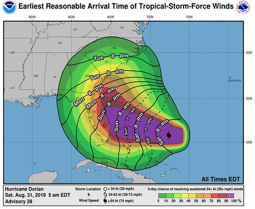
The initial motion is now 290/10. A low- to mid-level subtropical ridge to the north of the hurricane should steer it west-northwestward to westward for the next 48 h or so, with the forward speed becoming very slow as the center passes near or over the Abacos and Grand Bahama. The track guidance for this part of the track is tightly clustered, and the new forecast track is near the ECMWF, UKMET, and HCCA corrected consensus models. The track forecast becomes much more problematic after 48 h. The global models the NHC normally uses, along with the regional HWRF and HMON models, have made another shift to the east to the point where none of them forecast Dorian to make landfall in Florida. However, the UKMET ensemble mean still brings the hurricane over the Florida peninsula, as do several GFS and ECMWF ensemble members. The new track forecast for 72-120 h will be moved eastward to stay east of the coast of Florida, and it lies between the old forecast and the various consensus models. Additional adjustments to the forecast track may be necessary later today if current model trends continue. It should be noted that the new forecast track does not preclude Dorian making landfall on the Florida coast, as large portions of the coast remain in the track cone of uncertainty. Also, significant impacts could occur even if the center stays offshore.
Dorian should remain in a generally favorable environment for the next 3-4 days, and the intensity guidance indicates it will remain a powerful hurricane during this time. The new intensity forecast calls for a little more strengthening today, then it shows a slow weakening that follows the trend of the intensity guidance. During this time, the biggest intensity changes may come from hard-to-forecast eyewall replacement cycles. Late in the forecast period,increased vertical shear and proximity to land is expected to cause some weakening.
Key Messages
1. A prolonged period of life-threatening storm surge and devastating hurricane-force winds are likely in portions of the northwestern Bahamas, particularly on the Abaco Islands and Grand Bahama Island. A hurricane warning is in effect for these areas, and residents should listen to advice given by local emergency officials and have their hurricane preparations completed today.
2. Life-threatening storm surge and devastating hurricane-force winds are still possible along portions of the Florida east coast by the early to middle part of next week, but since Dorian is forecast to slow down and turn northward near the coast, it is too soon to determine when or where the highest surge and winds will occur. Residents should have their hurricane plan in place, know if they are in a hurricane evacuation zone, and listen to advice given by local emergency officials.
3. The risk of strong winds and life-threatening storm surge is increasing along the coasts of Georgia and South Carolina during the middle of next week. Residents in those areas should continue to monitor the progress of Dorian.
4. Heavy rains, capable of life-threatening flash floods, are expected over portions of the Bahamas and coastal sections of the southeastern United States this weekend through much of next week.


