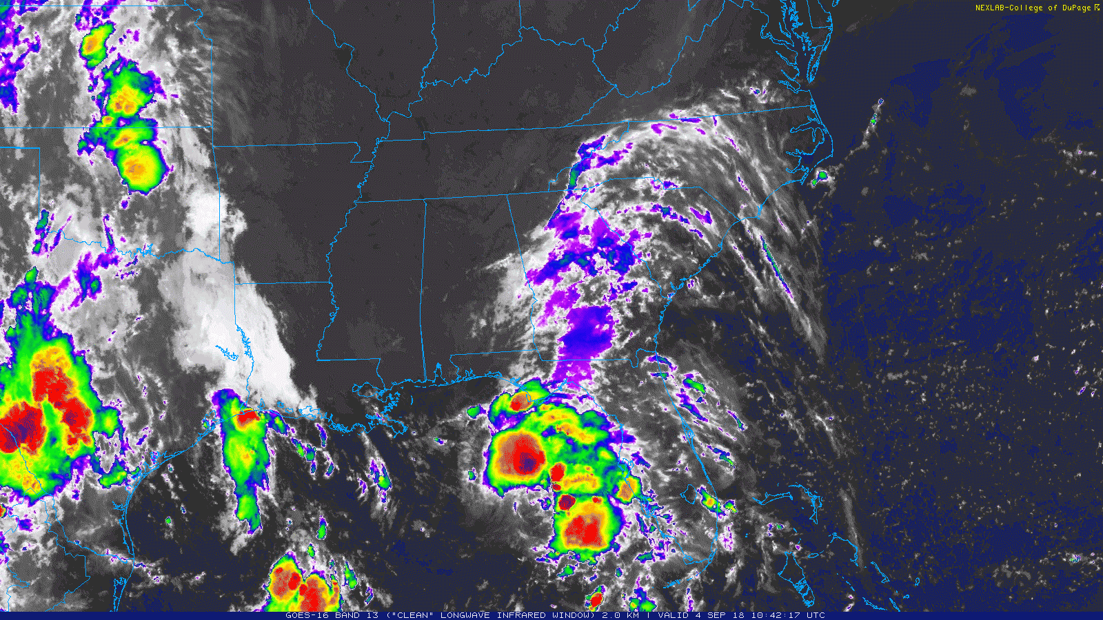
Tropical Storm Gordon continues to move across the Gulf of Mexico and toward the Mississippi coast. The low-level area of circulation is offset from most of the storm activity giving Gordon a one-sided look. Unfortunately for the northern Gulf coast states, most of the rain, wind and surge will be on the northern side of Gordon.
Where is this thing going?
The National Hurricane Center 7AM update shows Tropical Storm Gordon still moving west-northwest at about 15mph.
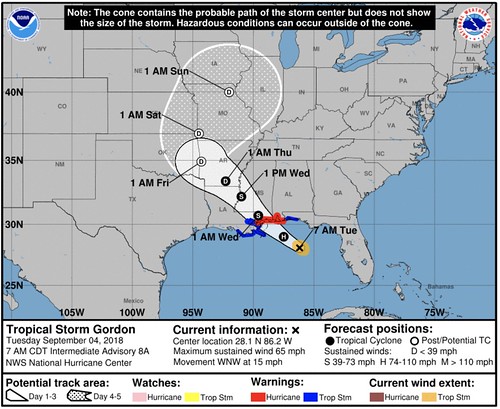
The forecast track hasn’t changed much during the last 24 hours and it looks like the storm is still on track to become a hurricane during the day today and is forecast to make landfall as a Category One hurricane along the Mississippi coast.
What’s going on?
To reiterate, Gordon is now a Tropical Storm but is anticipated to be a Hurricane at landfall. It will bring heavy rain, flooding, damaging wind, and isolated tornadoes with it as it moves ashore. Prepare for the storms by checking your hurricane preparedness kit, making sure you have water, food and medicines for everyone in your family. And enough to last up to two weeks.
FORECAST POSITIONS AND MAX WINDS
INIT 04/0900Z 27.7N 85.7W 55 KT 65 MPH
12H 04/1800Z 29.0N 87.5W 65 KT 75 MPH
24H 05/0600Z 30.7N 89.6W 55 KT 65 MPH…INLAND
36H 05/1800Z 32.2N 91.0W 35 KT 40 MPH…INLAND
48H 06/0600Z 33.4N 92.3W 25 KT 30 MPH…INLAND
72H 07/0600Z 34.9N 94.3W 20 KT 25 MPH…POST-TROP/REMNT LOW
96H 08/0600Z 37.0N 94.5W 20 KT 25 MPH…POST-TROP/REMNT LOW
120H 09/0600Z 40.0N 92.0W 20 KT 25 MPH…POST-TROP/REMNT LOW
When will it be here?
The national Hurricane Center has posted the Most Likely Arrival Time of wind for Gordon.
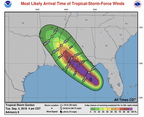
The first feeder bands may arrive as soon as Tuesday afternoon for south Mississippi, south Alabama and the Florida panhandle. The storms in those feeder bands may pack heavy rain, flash flooding, wind gusts up to 50mph and the potential for brief tornadoes.
Keep in mind that wind gusts during the feeder band storms is NOT the same as the sustained wind from the Tropical Storm that are highlighted in the picture above.
Who needs to worry?
Are you in the forecast Cone above? Then you need to worry. Near it? Then you need to worry.
The most frequent question I receive is “will it be bad for my house?” And I wanted to take a moment to clear some of the possible confusion up. Tropical Storm Gordon is 80 miles across. That is pretty wide. So when you read that there will be rain, flooding, and wind for a town within 80 miles of your location, just know that you will probably experience similar conditions.
Also, as an aside, everyone has a different definition of “bad” weather. So we are going to go with a flat definition of “any type of weather that may damage a building or hurt a person.”
If you live within a 15 minute drive to the Gulf of Mexico along the Mississippi coast, Alabama coast or Louisiana coast east of New Orleans… prepare for heavy rain, flooding, storm surge (up to 6 feet), damaging wind (gusts up to 85mph) and the possibility of tornadoes.
If you live within an hour drive of the Gulf of Mexico in Alabama, Mississippi, Louisiana or along the Florida panhandle west of Panama City… prepare for heavy rain, flooding, gusty wind (up to 70mph gusts) and the possibility for tornadoes.
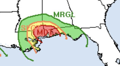
Thankfully the flooding threat is held in – relative – check by the forward speed of Gordon. But there is still the threat for flooding. the WPC has highlighted areas to watch out for flash flooding
Give me that ‘Why’ stuff Nick!
Not this time, that is coming up a bit later. This is just a no frills update.
How do I prepare? I’ve never been through a hurricane
A great place to start is Ready.gov or visit the Mobile, Alabama National Weather Service Office website. They have a lot of good info, too. More info on those two sites than I can pass along in a short blog post.


