The National Hurricane Center forecast track has shifted Gordon back to the east again. It is still looking to make landfall between Tuesday afternoon and Wednesday morning along he northern Gulf Coast – generally – between New Orleans, Louisiana and Mobile, Alabama.
The forecast may continue to wobble here and there during the next 24 hours. But some take-aways are starting to fall out of the forecast track.
Here are those take-aways…
Intensity guidance won’t be great
Given the track of Gordon relative to (1) local wind shear, (2) Gulf of Mexico Sea Height Anomoly, and (3) Gordon’s forward speed, forecasting the strength of Gordon may remain difficult to pin down.
Right now, Gordon is forecast to be a stout Tropical Storm at landfall with heavy rain, wind sustained at 60mph, and the possibility for isolated tornadoes on the northern side of the storm. There is also the likelihood of flooding in areas along the northern Gulf Coast between Lake Charles, Louisiana and Pensacola, Florida.
Wind shear
The wind shear is relaxing around Gordon and will continue to do so as it treks toward the northern Gulf Coast. How soon the upper level winds relax will dictate how much faster Gordon can wrap itself up and get organized.
Model guidance has been pretty consistent – and accurate – depicting this feature. But it is important to note that if there is any change to that, the forecast will change also.
Sea Height Anomaly
Because Gordon will be toeing the line between warmer-at-depth water and not-as-warm-at-depth water, the difference in track of as litle as 25 miles north-to-south could make the difference between a Tropical Storm and possible Hurricane.
Take a look at the forecast track super-imposed over the Gulf of Mexico Heat Height Anomaly:
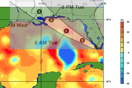
The Sea Height Anomaly is an indirect measure of sea heat content. Because warm things expand, this height anomaly can be used as a way to gauge if the water is warmer or cooler at the surface and at depth.
Speaking of “warm water at depth” here is a look at the 26C Isotherm super-imposed with the track of Gordon:
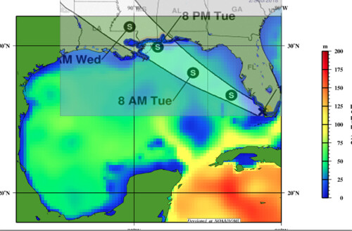
Notice it shows roughly the same thing. So this is a good double-check on if we are seeing the right thing. And we are.
Forward speed
Gordon’s forward speed will dictate just how long it spends on top of that warmer (or cooler) water. Right now, the storm is moving at – roughly – 15mph. That amount of forward momentum would limit the amount of intensification, but if it slows down, that would mean more time of the warmer waters and a higher likelihood of further strengthening.
Will it blow up like Katrina?
For reference, here is a look at the Rapid Intensification model data from the SHIPS model.
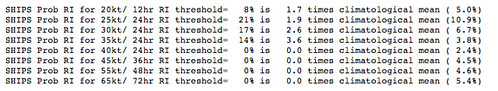
Notice that the probability of rapid intensification of 25kts of wind speed in 24 hours is around a one-in-five shot. Not great. But not zero.
The chance of a 35kt increase in that same time period is one-in-seven. Again, not a high chance, but also not zero. Another thing to pull out of that is the chances of rapid intensification, gaining another 35kts of wind speed in 24 hours, for this storm is about 3.5 times more likely for this storm, than the average tropical storm.
I don’t have access to the numbers for Katrina, but these numbers aren’t as high as they were for Harvey or Irma. Or Maria. That doesn’t mean it can’t happen, it just means the likelihood is lower.
The Bottom Line
You can see the differences discussed above in the intensity model data from Tropical Tidbits.
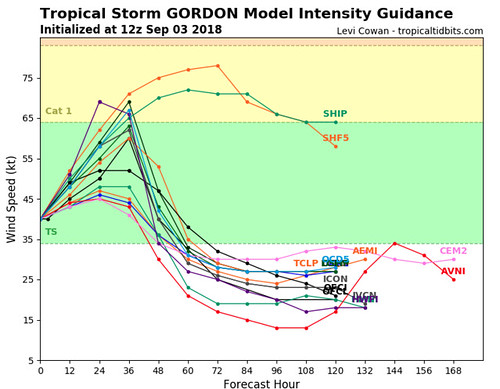
Notice that some of the lines go up and have Gordon as a hurricane. While others keep it as a Tropical Storm.
The bottom line, though: Prepare for one category higher than the storm is predicted. Right now, it is predicted to move ashore as a Tropical Storm. Prepare for a Category One hurricane. Prepare for heavy rain, flooding, wind speeds up to 80mph, the possibility for isolated tornadoes and – if you live along the coast – a storm surge.
From the NHC
CHANGES IN WATCHES AND WARNINGS WITH THIS ADVISORY…
A STORM SURGE WARNING HAS BEEN ISSUED FROM SHELL BEACH LOUISIANA
TO THE MISSISSIPPI-ALABAMA BORDER.
THE STORM SURGE WATCH HAS BEEN EXTENDED EASTWARD FROM THE
MISSISSIPPI-ALABAMA BORDER TO NAVARRE FLORIDA.
A HURRICANE WATCH HAS BEEN ISSUED FROM THE MOUTH OF THE PEARL RIVER
TO THE ALABAMA-FLORIDA BORDER.
THE TROPICAL STORM WARNING HAS BEEN EXTENDED EASTWARD TO THE
OKALOOSA-WALTON COUNTY LINE.
SUMMARY OF WATCHES AND WARNINGS IN EFFECT…
A STORM SURGE WARNING IS IN EFFECT FOR…
* SHELL BEACH TO MISSISSIPPI-ALABAMA BORDER
A STORM SURGE WATCH IS IN EFFECT FOR…
* WEST OF SHELL BEACH TO THE MOUTH OF THE MISSISSIPPI RIVER
* EAST OF THE MISSISSIPPI-ALABAMA BORDER TO NAVARRE
A HURRICANE WATCH IS IN EFFECT FOR…
* MOUTH OF THE PEARL RIVER TO THE ALABAMA-FLORIDA BORDER
A TROPICAL STORM WARNING IS IN EFFECT FOR…
* GOLDEN BEACH TO BONITA BEACH
* CRAIG KEY TO OCEAN REEF…INCLUDING FLORIDA BAY
* OKALOOSA-WALTON COUNTY LINE WESTWARD TO EAST OF MORGAN CITY…
LOUISIANA…INCLUDING LAKE PONTCHARTRAIN AND LAKE MAUREPAS


