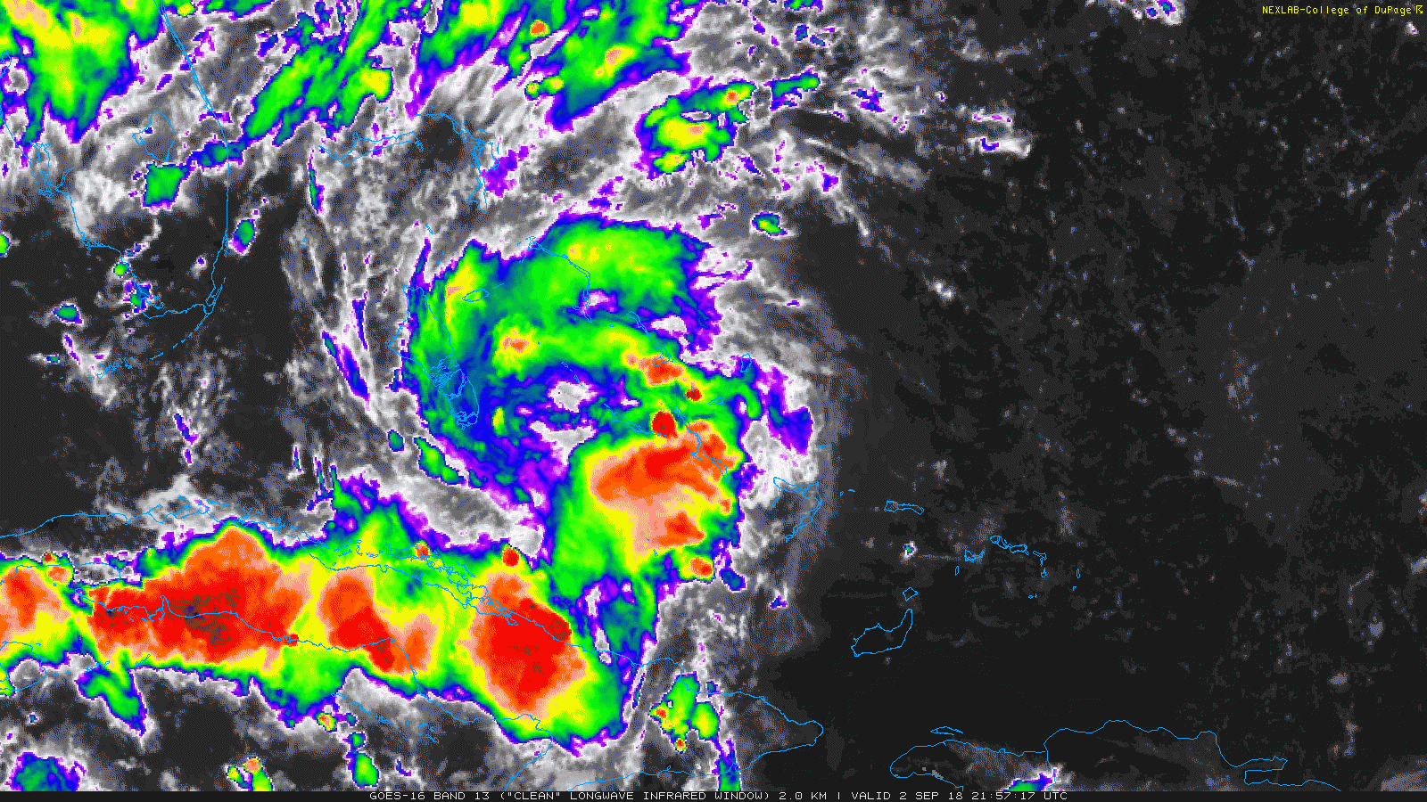
Here is a current look at Potential Tropical Cyclone Seven:
The latest from the National Hurricane Center:
SUMMARY OF 1100 PM EDT…0300 UTC…INFORMATION
———————————————–
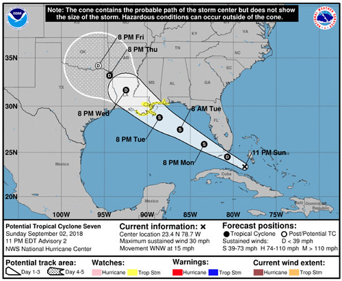
LOCATION…23.4N 78.7W
ABOUT 175 MI…285 KM ESE OF MARATHON FLORIDA
MAXIMUM SUSTAINED WINDS…30 MPH…45 KM/H
PRESENT MOVEMENT…WNW OR 300 DEGREES AT 15 MPH…24 KM/H
MINIMUM CENTRAL PRESSURE…1012 MB…29.89 INCHES
As per standard operating procedures, here is a breakdown of the “known knowns,” “known unknowns,” and “unknown unknowns” for Potential Tropical Cyclone Seven…
Known Knowns
Tropical Storm Watches are now in effect for the following areas:
*** Alabama-Florida border westward to east of Morgan City, Louisiana, including Lake Pontchartrain and Lake Maurepas
Interests in the Florida Keys and the southern Florida peninsula should monitor the progress of this system.
*** A Storm Surge Watch has been issued for the north-central Gulf coast from the Mississippi-Alabama border westward to the Mouth of the Mississippi River.
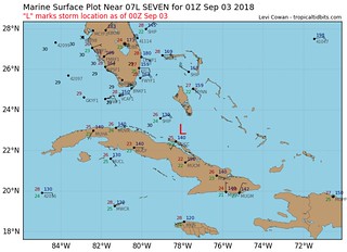
At 1100 PM EDT (0300 UTC), the disturbance was centered near latitude 23.4 North, longitude 78.7 West. The system is moving toward the west-northwest near 15 mph (24 km/h), and this general motion is expected to continue through Wednesday. On the forecast track, the disturbance will pass over the Florida Keys or the southern portion of the Florida peninsula Monday, and move over the southeastern Gulf of Mexico by Monday evening, and reach the central Gulf Coast by late Tuesday or Tuesday night.
Maximum sustained winds are near 30 mph (45 km/h) with higher gusts. Gradual strengthening is forecast during the next 48 hours, and the disturbance is forecast to become a tropical storm Monday night.
Conditions appear to be conducive for development, and this system is expected to become a tropical cyclone by Monday night.
* Formation chance through 48 hours…high…80 percent
* Formation chance through 5 days…high…80 percent
Potential Tropical Cyclone Seven is a cluster of storms with a developing area of surface low pressure near the Bahamas and the Florida and Cuba coasts. The system is moving WNW at about 15mph and will enter the Gulf of Mexico during the next 24 hours.
Potential Tropical Cyclone Seven is gaining strength and organizing, aided by the warmer waters near the Bahamas. The easing off of the wind shear is also helping this system organize itself.
The current model data suggest a high likelihood – but not guarantee – that Potential Tropical Cyclone Seven will continue to gain strength and develop into a Tropical Storm. That is why Tropical Storm Watches are in effect.
The Gulf of Mexico is very warm. But not terribly warm at depth across the entire Gulf. There is a big area of not-that-deep warmer water.
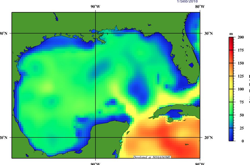
The 26-degree Celsius isotherm tells us a lot about the warm water in the Gulf of Mexico. It shows us the area where there is more warm water at depth. That is important for a lot of reasons… but the main reason is that it is a great measure of how much “food” is available for developing systems to “eat” so to speak.
The deeper the warmer water, the more that can be brought to the surface as the rain-cooled water on the surface sinks. The physics works a lot like summertime convection we have in the atmosphere.

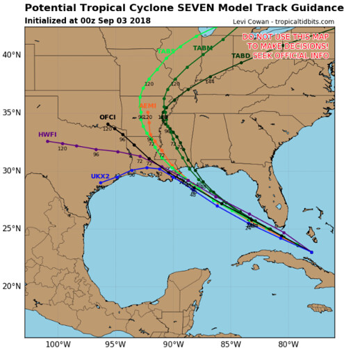
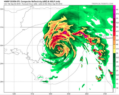
Model guidance shows that as Potential Tropical Cyclone Seven moves over those warmer waters, it will intensify.
Model track guidance continues to show a path to the west-northwest, around 15mph, across the Gulf of Mexico.
It will rain between Lake Charles, Louisiana and Pensacola, Florida between Tuesday morning and Thursday night.
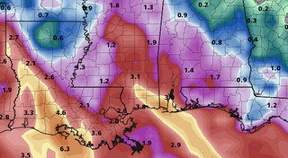
Confidence is pretty high – so much so that I’ve included this in the ‘known knowns’ section – that the areas along the Gulf coast will see a lot of rain from Potential Tropical Cyclone Seven. Between two inches and four inches of rain is showing up in the GFS computer weather model precipitation estimate.
While this is probably a low-end estimate, it does hold true with the forecast for a fair amount of rain along the Gulf Coast.
Try not to focus on individual points when looking at the map here with rainfall estimates, but rather use that as a fence for rainfall totals.
Somewhere between one-inch of rain and six-inches of rain will be possible with this system as it moves through the Gulf Coast area.
The last of the “known knowns” is that model data is slowly showing this to be a stronger storm as it moves across the Gulf. Not a Big Hurricane, by any means, but also a bit stronger than a weak Tropical Storm.
The increases in storm intensity are slight, but are also trending up during the last 24 hours. So, please, prepare for this storm appropriately.
Known Unknowns
Future intensity.
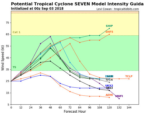
Despite stating above that model guidance data is showing a trend of higher intensity, right now we don’t know – specifically – how strong it will get.
Here is a look at one model estimate:
But, don’t let that worry you. Unknowns are completely normal for forecasting tropical systems before they form completely.
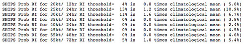
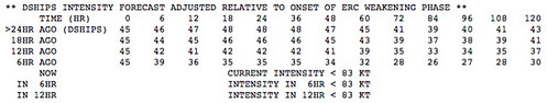
The good news is despite the uncertainty about intensification, there is currently only a 13% chance that there is “rapid intensification” according to the same SHIPS model referenced above.
Unknown Unknowns
Because it is the atmosphere, there are going to be things that are going to happen that we cannot foresee at this time. That is why it is important to be prepared for all possible outcomes. Live along the East Coast? Or along the Gulf Coast? Check your Hurricane Preparedness Kit. Don’t have one? Buy one! There is no need to do much else yet. Check your plan, make sure your kit is ready to go and wait for the meteorological world to figure out what will happen with PTC7.
Being prepared today means when it is time to act, you’ll be ready to go!
The Bottom Line & Preparations
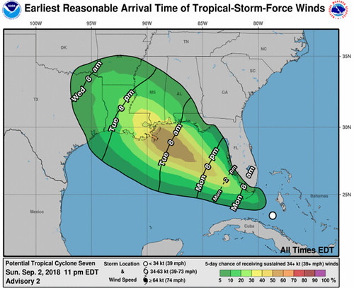
We are still gathering data and trying to nail down specifics on this forecast, but for now, if you live along the Gulf Coast between – roughly – Lake Charles, Louisiana and Pensacola, Florida, prepare for heavy rain, some gusty wind, the possibility for isolated tornadoes and high surf and waves (if you live along the coast).
The system will start to influence your weather between Tuesday morning and Friday morning. So if you have plans between Tuesday and Thursday to be outside, make sure you make alternative plans.
From the National Hurricane Center:
Key Messages:
1. Potential Tropical Cyclone Seven will bring heavy rainfall and gusty winds to portions of the Bahamas, South Florida, and the Florida Keys tonight and Monday, and interests in those areas should monitor the progress of this system.
2. A Tropical Storm Watch has been issued for portions of the central Gulf Coast, and tropical storm conditions are possible in those areas Tuesday night and Wednesday. Heavy rainfall from this system will affect portions of the central Gulf Coast later this week, including areas that are currently receiving heavy rainfall from a different weather system. Interests in these areas should monitor products from their local National Weather Service office.
3. Users should be aware that forecast uncertainty for potential tropical cyclones is generally larger than that for tropical cyclones, especially beyond 48-72 hours.
FORECAST POSITIONS AND MAX WINDS
INIT 03/0300Z 23.4N 78.7W 25 KT 30 MPH…POTENTIAL TROP CYCLONE
12H 03/1200Z 24.5N 80.7W 30 KT 35 MPH
24H 04/0000Z 25.9N 83.4W 35 KT 40 MPH
36H 04/1200Z 27.5N 86.2W 40 KT 45 MPH
48H 05/0000Z 28.8N 88.6W 50 KT 60 MPH
72H 06/0000Z 31.7N 92.5W 30 KT 35 MPH…INLAND
96H 07/0000Z 33.2N 94.4W 25 KT 30 MPH…INLAND
120H 08/0000Z 34.2N 95.7W 20 KT 25 MPH…POST-TROP/REMNT LOW
Not even 50% of households have developed an emergency plan and talked about it with their families. Oftentimes, people just don’t know where to start. As we kick off this year’s #NatlPrep Month in September, we’re working with @Readygov to change that! #PrepareNow pic.twitter.com/9bM0BtdHis
— Ad Council (@AdCouncil) August 31, 2018


