Hurricane Dorian continues to track – slowly – to the west. It is slowly coming to a stop and is still anticipated to turn north.
Here is the latest from the NHC:
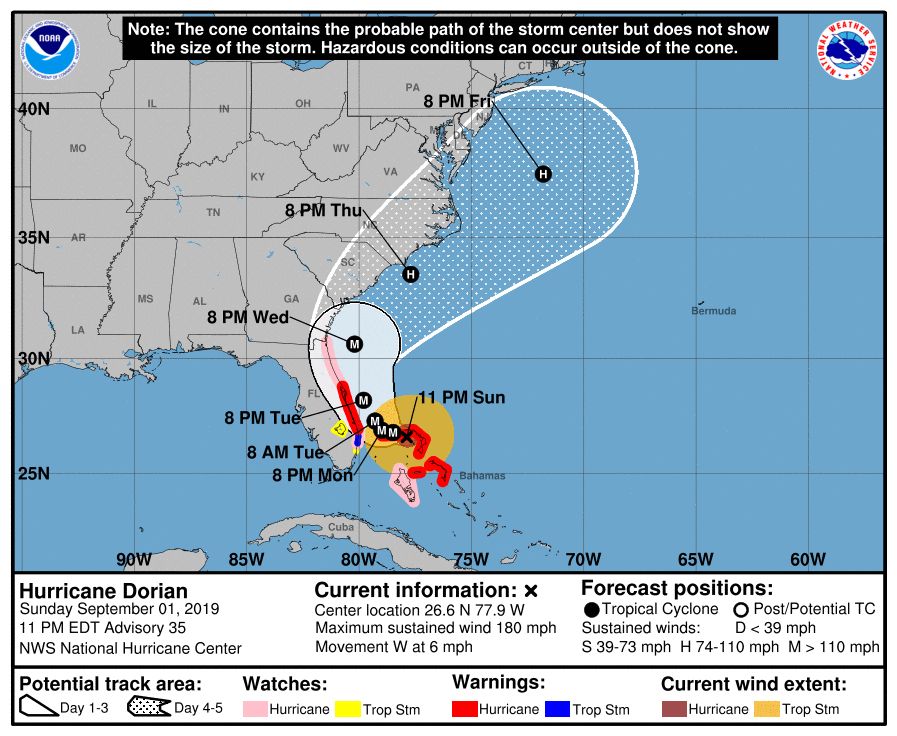
SUMMARY OF 1100 PM EDT…0300 UTC…INFORMATION
———————————————–
LOCATION…26.6N 77.9W
ABOUT 55 MI…90 KM E OF FREEPORT GRAND BAHAMA ISLAND
ABOUT 135 MI…220 KM E OF WEST PALM BEACH FLORIDA
MAXIMUM SUSTAINED WINDS…180 MPH…285 KM/H
PRESENT MOVEMENT…W OR 275 DEGREES AT 6 MPH…9 KM/H
MINIMUM CENTRAL PRESSURE…914 MB…26.99 INCHES
FORECAST POSITIONS AND MAX WINDS
INIT 02/0300Z 26.6N 77.9W 155 KT 180 MPH
12H 02/1200Z 26.8N 78.5W 145 KT 165 MPH
24H 03/0000Z 26.9N 79.0W 135 KT 155 MPH
36H 03/1200Z 27.3N 79.3W 125 KT 145 MPH
48H 04/0000Z 28.2N 79.8W 120 KT 140 MPH
72H 05/0000Z 30.6N 80.2W 105 KT 120 MPH
96H 06/0000Z 33.5N 77.7W 85 KT 100 MPH
120H 07/0000Z 37.5N 71.8W 75 KT 85 MPH
SUMMARY OF WATCHES AND WARNINGS IN EFFECT:
A Storm Surge Warning is in effect for…
* Lantana to the Volusia/Brevard County Line
A Storm Surge Watch is in effect for…
* North of Deerfield Beach to Lantana
* Volusia/Brevard County Line to the Mouth of the St. Mary’s River
A Hurricane Warning is in effect for…
* Northwestern Bahamas excluding Andros Island
* Jupiter Inlet to the Volusia/Brevard County Line
A Hurricane Watch is in effect for…
* Andros Island
* North of Deerfield Beach to Jupiter Inlet
* Volusia/Brevard County Line to the Mouth of the St. Mary’s River
A Tropical Storm Warning is in effect for…
* North of Deerfield Beach to Jupiter Inlet
A Tropical Storm Watch is in effect for…
* North of Golden Beach to Deerfield Beach
* Lake Okeechobee
NHC brief discussion
At 1100 PM EDT (0300 UTC), the center of Hurricane Dorian was located near latitude 26.6 North, longitude 77.9 West. Dorian is moving toward the west near 6 mph (9 km/h). A slower westward to west-northwestward motion is forecast during the next day or so, followed by a gradual turn toward the northwest. On this track, the core of extremely dangerous Hurricane Dorian will continue to pound Great Abaco and Grand Bahama islands overnight and through much of Monday. The hurricane will move dangerously close to the Florida east coast late Monday through Tuesday night.
Maximum sustained winds are near 180 mph (285 km/h) with higher gusts. Dorian is a category 5 hurricane on the Saffir-Simpson Hurricane Wind Scale. Slow weakening is forecast, but fluctuations in intensity could occur couple of days. Regardless, Dorian isexpected to remain a powerful hurricane during the next few days.
Hurricane-force winds extend outward up to 45 miles (75 km) from thecenter and tropical-storm-force winds extend outward up to 140 miles (220 km).
The estimated minimum central pressure is 914 mb (26.99 inches).
Key Messages
1. A prolonged period of catastrophic winds and storm surge will affect the Abaco Islands and Grand Bahama Island for several more hours. Everyone there should take immediate shelter and not venture into the eye.
2. Life-threatening storm surges and dangerous hurricane-force winds are expected along portions of the Florida east coast through mid-week, and storm surge and hurricane warnings are in effect. Only a slight deviation to the left of the official forecast would bring the core of Dorian near or over the Florida east coast. Residents should listen to advice given by local emergency officials.
3. There is an increasing likelihood of strong winds and dangerous storm surge along the coasts of Georgia, South Carolina, and North Carolina later this week. Residents in these areas should continue to monitor the progress of Dorian and listen to advice given by local emergency officials.
4. Heavy rains, capable of producing life-threatening flash floods, are expected over northern portions of the Bahamas and coastal sections of the southeast and lower mid-Atlantic regions of the United States through late this week.
NHC Extended Discussion
Hurricane Dorian Discussion Number 35
NWS National Hurricane Center Miami FL AL052019
1100 PM EDT Sun Sep 01 2019
Dorian remains an incredibly powerful hurricane and it is currently making landfall on the eastern end of Grand Bahama Island. Satellite images show an symmetrical cyclone with a circular 10 n mi diameter eye and intense eyewall convection with lots of lightning being detected. Doppler radar data from Miami and the Bahamas show that Dorian has developed concentric eyewalls, and this feature is also noted by a double wind maximum that is evident in data from the Air Force Hurricane Hunters. The initial intensity of Dorian is set at 155 kt based mostly on the SFMR winds from the aircraft. The aircraft data also indicated that the radii of tropical-storm-force winds are a little larger than they were earlier today.
Dorian is still moving slowly westward at about 5 kt. The ridge to the north of Dorian is gradually weakening and shifting eastward in response to a mid- to upper-level trough that is moving across the eastern U.S. This change in the steering pattern should cause Dorian to slow down even more and perhaps stall, before it turns to the northwest late Monday or early Tuesday. This expected slow motion will likely be devastating to the Great Abaco and Grand Bahama Islands since it would prolong the catastrophic winds, storm surge, and rainfall over those areas.
The timing of the northwest or north turn is very critical in determining how close Dorian will get to the Florida peninsula on Tuesday and Wednesday. In general, the track models have changed little from the previous cycle, and the NHC forecast continues to show the core of Dorian very near, but offshore, of the Florida peninsula on Tuesday and Wednesday. The hurricane is then expected to track near the Georgia and Carolinacoasts late this week. This forecast is in best agreement with the various consensus models, which typically have the lowest errors. It is once again emphasized that although the official track forecast does not show landfall, users should not focus on the exact track. A small deviation to the left of the track could bring the intense core of the hurricane and its dangerous winds closer to or onto the Florida coast.
Category 5 hurricanes like Dorian usually don’t hold that intensity for very long, and it is expected that Dorian will weaken slowly during the next few days. However, the observed eyewall replacement cycle will likely cause fluctuations in strength, both up and down, while the system is near Florida. The models show an increase in shear when Dorian tracks near Georgia and the Carolinas, which should cause more notable weakening. This forecast is near the high end of the latest model guidance.
Based on this forecast, the hurricane watch has been extended northward to the Florida-Georgia line.
Brief evacuation information
Here are some tweets with evacuation information as of 10PM Central Time on 9/1/19.
Starting noon tomorrow, individuals east of I-95 in Bryan, Camden, Chatham, Glynn, Liberty, and McIntosh Counties must evacuate due to Hurricane #Dorian. @GeorgiaEMA and @GADeptofTrans will start westerly contraflow on I-16 at 8 AM on Tuesday, Sept. 3. Stay vigilant and be safe. pic.twitter.com/njw2ffCoLT
— Governor Brian P. Kemp (@GovKemp) September 2, 2019
Because Hurricane Dorian is headed towards South Carolina as a category 5 storm and is very dangerous, @henrymcmaster has initiated a mandatory evacuation for eight counties, which can be viewed @SCEMD .
I want to urge you to please take the necessary precautions…
1/3
— Congressman William Timmons (@RepTimmons) September 2, 2019
BREAKING: Georgia’s governor orders mandatory evacuation of state’s coast starting at midday Monday ahead of Hurricane #Dorian. Multiple sources say the order includes people in areas east of I-95 in Bryan, Camden, Chatham, Glynn, Liberty and McIntosh counties.
— Brandon Robinson (@brobwx) September 2, 2019
A brief history of Dorian
Some great work from Dr. Kim wood up at Mississippi State showing the life-span of Dorian.
Eight days of Dorian: from minimal tropical storm to today’s category 5 monster pic.twitter.com/5mmDgeGmqF
— Kim Wood (@DrKimWood) September 2, 2019
Model Data updates
The model guidance for track for Dorian is trending a bit further west over the last 24 hours.
Global (GFS/ECMWF) and hurricane (HWRF/HMON) models have all been trending westward over their last several runs, respectively. The slightest nudge west in #Dorian‘s track can be a catastrophic situation for Florida. pic.twitter.com/Nt9hCwavlZ
— John Kassell (@JPKassell) September 2, 2019
The movement in the models is also noted in the spaghetti models.

The westward movement should slow, soon. As noted here, there is a westward limit that – appears – to be evident.
We have our anchor analysis points.
The wall, the stalled receptive area, packing vertical contours.
Now watch the W-Periphery of the cyclone to give final clue as it mirrors the flattened contours.
Then you work it back to stall & turn somewhere along Grand Bahama. pic.twitter.com/N1bBQWSZJ0— crankyweatherguy (@crankywxguy) September 2, 2019
The reason for the hard turn is the opening between two ridges of high pressure.

Take a look at the two teal-colored lines. The middle of those are the alleyway for Dorian to start to sneak north and northeast, noted by the yellowish arrows. And eventually it will get picked up by the next trough that swings through the northeast.
By Tuesday afternoon, the alleyway widens.

And the trough gets closer, and away goes Dorian.
Another way to highlight the movement here:
So naturally the next question is, what causes the #Dorian to start moving again?
Essentially one ridge becomes stronger (NATL ridge), while the other one weakens (Midwest US), with progressive troughs making sure the weakness stays open. Breakdown below⬇️ pic.twitter.com/OZcttX3T4D
— Philippe Papin (@pppapin) September 2, 2019
What parts of the forecast that are a total lock?
None. This forecast is likely to change. Sadly, with tropical systems nothing is ever truly ‘locked in’ which is why we always encourage you to follow the forecast with these systems closely. It is also why we try our best to kick out new forecasts as much as possible.
What can change?
A lot, like always. Please keep tabs on this forecast as we head through the next few days for changes.
Beyond 72 hours, the track is still a bit up in the air. As is the intensity. The reason is the ridge that is building over the area now, may ease back tot he east through the next 72 hours. That is what opens the door, so to speak, to allow Dorian to move north.
There isn’t a front moving into the area to pull Dorian out. It is more so that there is an alleyway that opens up to allow Dorian to move north.

Notice that right now (graphic on the far right) there is a ridge blocking Dorian’s path north all the way across the Southeast.
But in 24 hours (bottom left graphic), that ridge starts to break down, allowing Dorian to now move north once it enters the Gulf of Mexico.
But notice in the next graphic (top left) that the ridge breaks down and pulls north and it allows Dorian to move north.
So, we are waiting to see how fast that ridge breaks down. The sooner it breaks down, the faster/sooner Dorian moves north. The longer the ridge lingers, the further west Dorian makes it.
And at this point, we can’t know for certain when exactly that will happen. All we know is that it will happen sometime between Sunday and Tuesday.
The Bottom Line
If you live in Florida
Prepare for one category higher than the forecast. The forecast is currently for a Category 4 Hurricane to make landfall. Prepare for a Category 5.
For more information about preparing for a hurricane, head to Ready.Gov
If you live along the northern Gulf Coast
So for now, check your Hurricane Preparedness Kit, check your supplies, make sure you have a plan. Double-check your insurance coverage, make sure you don’t have trees with loose branches or dead limbs around or near the house, and check nearby storm drains. But outside of that, just hang tight!
If you live up the East Coast
As Dorian shifts north, eventually it may become an issue along the East Coast. Be sure you are keeping tabs on this system and where it is headed.


