Quite the active scene in the Tropics. Across parts of the eastern Pacific and northern Atlantic there are six named storms and three other areas of interest. Not a record (to my knowledge) but probably close.
As the MJO shifts back to our side of the world, this activity is likely going to continue over the next week. Then the MJO transitions to the east and away from this region of the globe, allowing the overall activity to diminish.
In the meantime, though, there is a lot to manage!
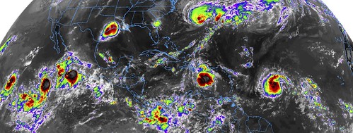
The GOES-16 imagery above is able to capture all of the active tropical systems in the eastern Pacific and northern Atlantic.
From the NHC
Hurricane Humberto

SUMMARY OF 1100 AM AST…1500 UTC…INFORMATION
———————————————–
LOCATION…32.2N 68.1W
ABOUT 195 MI…310 KM W OF BERMUDA
MAXIMUM SUSTAINED WINDS…120 MPH…195 KM/H
PRESENT MOVEMENT…ENE OR 65 DEGREES AT 16 MPH…26 KM/H
MINIMUM CENTRAL PRESSURE…952 MB…28.12 INCHES
At 1100 AM AST (1500 UTC), the center of Hurricane Humberto was located and Air Force Reserve Hurricane Hunter aircraft near latitude 32.2 North, longitude 68.1 West. Humberto is now moving toward the east-northeast near 16 mph (26 km/h). This general motion with an additional increase in forward speed is expected through early Thursday, followed by a northeastward to north-northeastward motion through Friday. On the forecast track, the core of Humberto is expected to pass just to the northwest and north of Bermuda later tonight.
Reports from the reconnaissance aircraft indicate that maximum sustained winds have increased to near 120 mph (195 km/h) with higher gusts. Humberto is a category 3 hurricane on the Saffir-Simpson Hurricane Wind Scale. Some fluctuations in intensity are likely during the next day or so, but Humberto should remain a powerful hurricane through early Thursday while it passes close to Bermuda. A steady weakening trend should begin later on Thursday.
Humberto is a large hurricane and continues to grow in size. Hurricane-force winds now extend outward up to 105 miles (165 km) from the center and tropical-storm-force winds extend outward up to 195 miles (315 km) based on reports from the Hurricane Hunter aircraft.
The minimum central pressure recently measured by the reconnaissance aircraft was 952 mb (28.12 inches).
Tropical Depression Imelda
SUMMARY OF 1000 AM CDT…1500 UTC…INFORMATION
———————————————–
LOCATION…30.6N 95.6W
ABOUT 65 MI…100 KM N OF HOUSTON TEXAS
ABOUT 50 MI…75 KM E OF COLLEGE STATION TEXAS
MAXIMUM SUSTAINED WINDS…30 MPH…45 KM/H
PRESENT MOVEMENT…N OR 360 DEGREES AT 5 MPH…7 KM/H
MINIMUM CENTRAL PRESSURE…1009 MB…29.80 INCHES
At 400 AM CDT (0900 UTC), the center of Tropical Depression Imelda was located near latitude 30.0 North, longitude 95.6 West. The depression is moving toward the north near 5 mph (7 km/h) and this motion is expected to continue over the next couple of days with a slight turn to the north-northwest.
Maximum sustained winds are near 30 mph (45 km/h) with higher gusts. Additional weakening is forecast during the next 48 hours.
The estimated minimum central pressure is 1007 mb (29.74 inches).
Tropical Storm Jerry

SUMMARY OF 1100 AM AST…1500 UTC…INFORMATION
———————————————–
LOCATION…14.6N 49.2W
ABOUT 855 MI…1375 KM E OF THE LEEWARD ISLANDS
MAXIMUM SUSTAINED WINDS…50 MPH…85 KM/H
PRESENT MOVEMENT…WNW OR 290 DEGREES AT 14 MPH…22 KM/H
MINIMUM CENTRAL PRESSURE…1002 MB…29.59 INCHES
At 1100 AM AST (1500 UTC), the center of Tropical Storm Jerry was located near latitude 14.6 North, longitude 49.2 West. Jerry is moving toward the west-northwest near 14 mph (22 km/h). A west-northwest motion at a slightly faster forward speed is expected over the next few days. On the forecast track, the system will be near the northern Leeward Islands Friday and pass north of Puerto Rico on Saturday.
Maximum sustained winds have increased to near 50 mph (85 km/h) with higher gusts. Jerry is forecast to become a hurricane by late Thursday, with little change in strength anticipated on Friday and Saturday.
Tropical-storm-force winds extend outward up to 45 miles (75 km) from the center.
The estimated minimum central pressure is 1002 mb (29.59 inches).
Other Areas of interest

Tropical Weather Outlook
NWS National Hurricane Center Miami FL
800 AM EDT Wed Sep 18 2019
For the North Atlantic…Caribbean Sea and the Gulf of Mexico:
The National Hurricane Center is issuing advisories on Hurricane Humberto, located a few hundred miles west of Bermuda, and on Tropical Storm Jerry, located several hundred miles east of the Leeward Islands.
1. A tropical wave located several hundred miles west of the Cabo Verde Islands is producing disorganized cloudiness and showers. Some development of this system is possible over the weekend while the system approaches the Windward Islands or across the southeastern Caribbean Sea early next week.
* Formation chance through 48 hours…low…near 0 percent.
* Formation chance through 5 days…low…30 percent.
2. A tropical wave is forecast to move off of the west coast of Africa on Thursday. Development, if any, is expected to be slow to occur through early next week while the system moves generally westward at 10 to 15 mph.
* Formation chance through 48 hours…low…near 0 percent.
* Formation chance through 5 days…low…10 percent.
Public Advisories on Tropical Storm Jerry are issued under WMO header WTNT35 KNHC and under AWIPS header MIATCPAT5.
Forecast/Advisories on Tropical Storm Jerry are issued under WMO header WTNT25 KNHC and under AWIPS header MIATCMAT5.
Not from the NHC
There is one other little area that may be worth watching in the coming days that is in the Caribbean. This little thing isn’t shown to develop by any of the modeling that is available, however I think it is still worth noting.
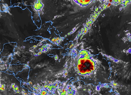
This little wave is going to lift west-northwest toward the Gulf this weekend and into early next week. It isn’t really moving quickly and is fairly disorganized. It will have to deal with a fair amount of land interaction and some shear, too.
This is probably why the NHC isn’t highlighting it, it has a rough journey ahead.
However, by Tuesday or next week the ECMWF computer weather model puts it in the middle of the Gulf of Mexico on the south side of a weak ridge. That may put it in a place where organization is possible (though, still not “likely”).


