What’s the deal with all this rain?
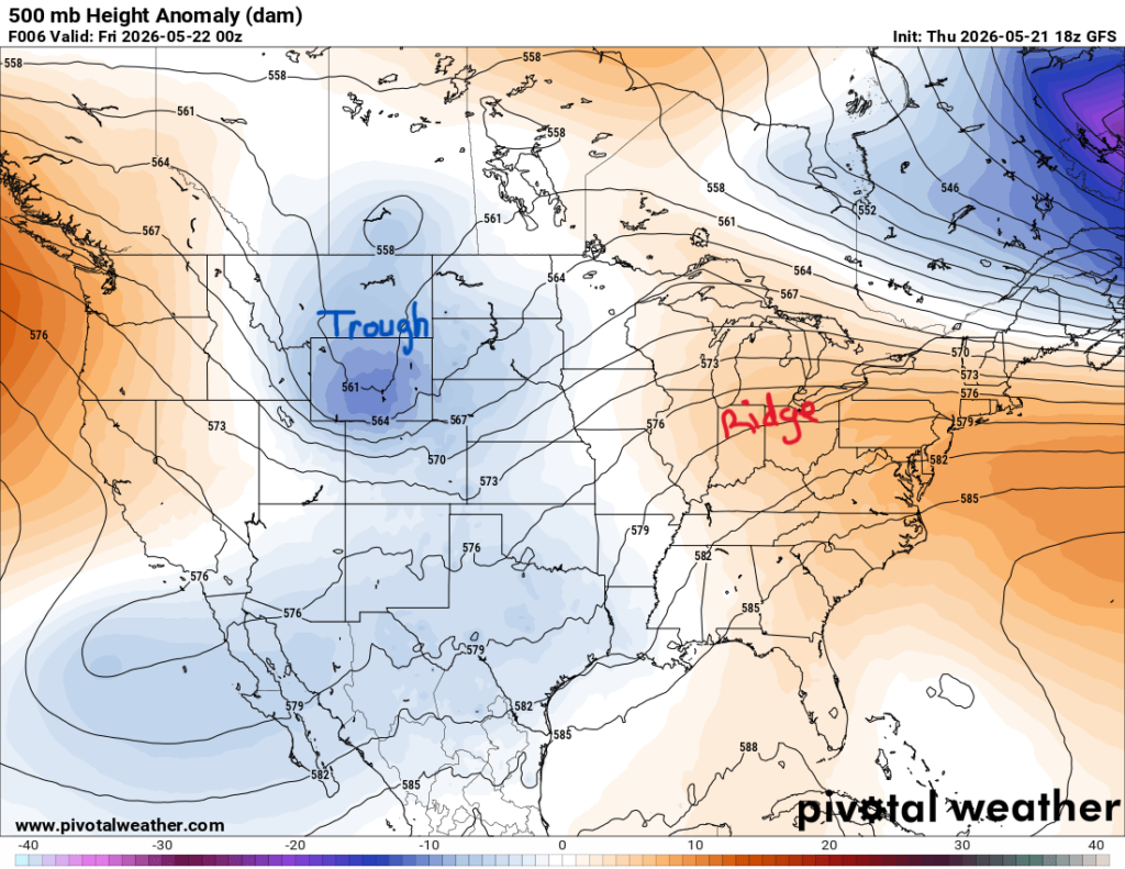
Looking higher up in the atmosphere at the mid-levels, also known as the steering level (like steering wheel hah), our region is sitting between a trough out west and a ridge over the eastern U.S. With winds following that flow, they’re blowing from the southwest to the northeast. This set-up helps bring in moisture, supports rising motion, and allows disturbances to move through our region.
Early June this pattern is set to change and do a flip-flop shown below.
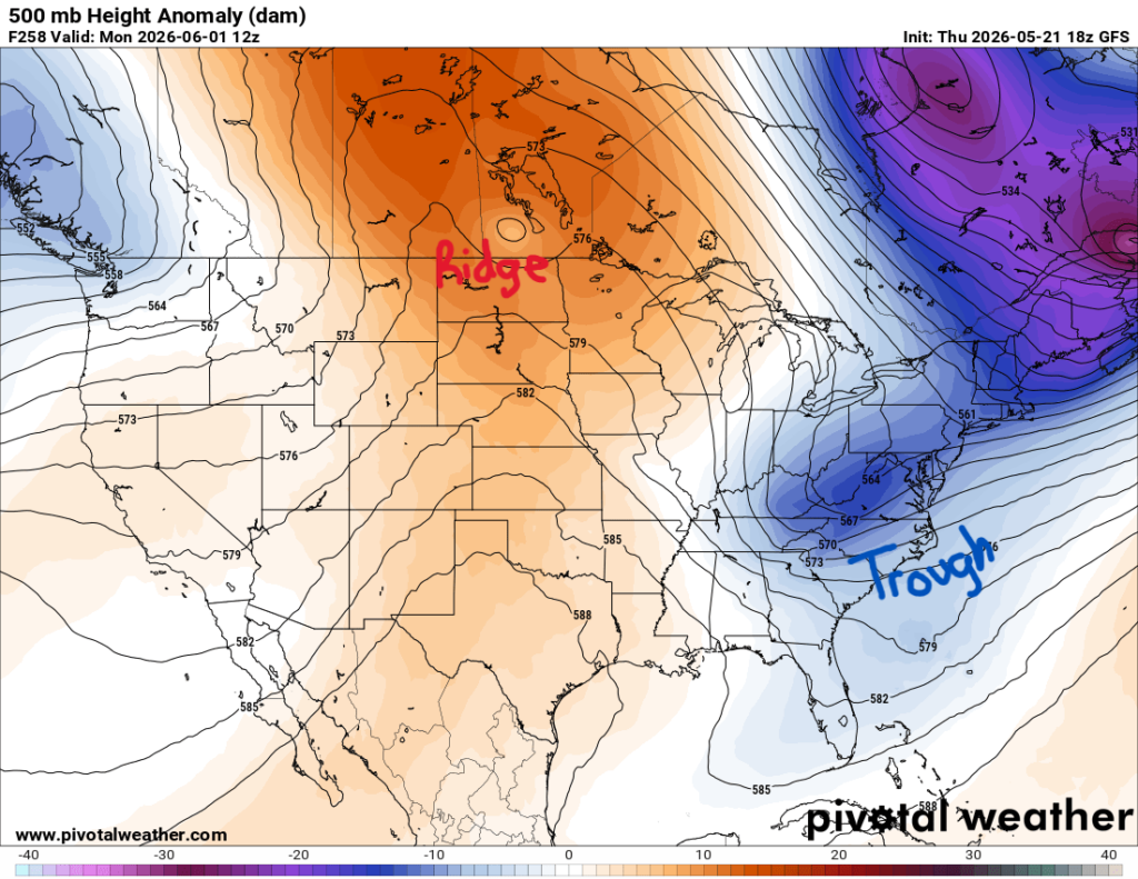
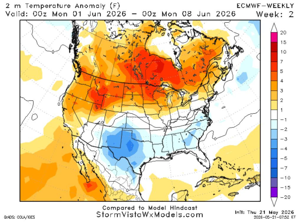
Long-range models show a ridge forming over the central U.S. and a trough off the East Coast. In other words, June will greet us with some much-needed drier weather and temperatures ranging from below normal to normal, as shown below.
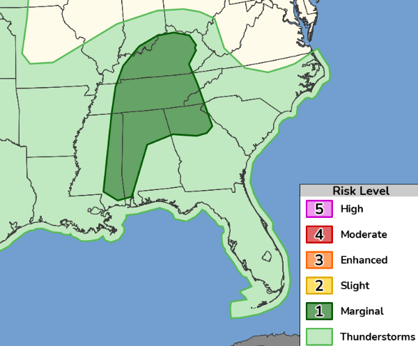
Severe Weather Outlook
In the meantime, the Storm Prediction Center has placed eastern Mississippi and western Alabama under a Marginal Risk (Level 1/5) for severe weather tomorrow. Scattered to numerous thunderstorms are expected during the afternoon and evening hours, with threats of small hail, damaging winds up to 60 mph, and though the threat is small, we can’t rule out a few brief tornadoes.
Flood warnings and a couple of advisories have been issued across southern Mississippi and northern Louisiana. Areas along the Texas and Louisiana coastline have saturated soils, making them more susceptible to flooding with the next rounds of rain this weekend.
3-DAY TRAVEL FORECAST
Airports
KIAH / KHOU (Houston) – Afternoon showers and storms possible each day. Slight excessive rainfall risk starting Saturday, minor roadway flooding potential extending through Sunday morning. Lightning could delay flights.
KSHV (Shreveport) – Afternoon showers and storms possible each day. A better shot for rain and storms arrives Saturday evening. Some intermittent flight delays are possible for lightning. Watch roadways for ponding and keep watch for flash flooding.
KBTR (Baton Rouge) – Afternoon showers and storms possible each day. A better shot for rain and storms arrives Saturday evening. Some intermittent flight delays are possible for lightning. Watch roadways for ponding and keep watch for flash flooding.
KMSY (New Orleans) – Afternoon showers and storms possible each day. A better shot for rain and storms arrives Saturday evening. Some intermittent flight delays are possible for lightning. Watch roadways for ponding and keep watch for flash flooding.
KJAN (Jackson) – Showers possible each day. Thunderstorms possible Sunday evening. Some intermittent flight delays are possible for lightning. Watch roadways for ponding and keep watch for flash flooding.
KMOB (Mobile) – Afternoon showers and storms possible each day. Friday morning expect a line of showers/storms in the morning continuing through the evening hours. Some intermittent flight delays are possible for lightning. Watch roadways for ponding and keep watch for flash flooding.
KBMH (Birmingham) – Afternoon showers and storms possible each day. Some intermittent flight delays are possible for lightning. Watch roadways for ponding and keep watch for flash flooding.
KTLH (Tallahassee) – Low-end chance for afternoon storms Saturday and Sunday.
KATL (Atlanta) – Showers and storms possible each day. High chance for evening storms on Friday. Intermittent weather delays possible for some flights due to lightning.
Highways
I-10
Scattered to numerous showers and thunderstorms each day Friday through Sunday, with the heaviest activity Friday through Saturday. Brief heavy rain, lightning, and ponding on roads possible at times.
I-20
Daily rounds of showers and storms, most widespread Friday and Sunday across Mississippi and Alabama. Locally heavy downpours may briefly slow travel.
I-49
Saturday evening storms could impact travel, showers all day Sunday. Watch for ponding on road.
I-55 & I-59
Active stretch starting Saturday overnight into Sunday evening. Some storms could produce heavy rain and brief roadway ponding.
I-65
Friday showers and afternoon thunderstorms. Drive slowly in heavy downpours. Saturday looks mostly clear. Sunday morning scattered showers. Watch for ponding.
I-75
Friday evening storms. Drive slowly in heavy downpours. Saturday looks mostly clear. Sunday has chances for scattered storms/showers.
CITY FORECASTS
Houston, TX
Friday– Chance of showers/thunderstorms all day, higher in the evening. High of 85 with 5mph south winds.
Saturday – High chance of thunderstorms in the afternoon. High near 83. Southeast wind around 5mph.
Sunday – High chance of morning and afternoon storms. High near 81. Winds will blow from the northeast at 5 mph.
Shreveport, LA
Friday– Chance of showers and thunderstorms in the afternoon. Partly sunny with a high near 84. WEst wind blowing at 5mph.
Saturday – Watch for patchy fog in the morning. High chance of showers between 7am and 1pm. Otherwise, partly sunny with a high near 85. Light south breeze.
Sunday – Showers and possibly a thunderstorm. High around 80 and light winds blowing from the southeast.
Baton Rouge, LA
Friday– Chance of showers and thunderstorms, mainly after 11am. High near 82. Southeast wind around 5 mph becoming west in the afternoon.
Saturday – High chance of showers and thunderstorms, then showers and possibly a thunderstorm after 7am. High of 84. Light south winds
Sunday – High showers/thunderstorm chances all day. High near 81. Light sound wind. Watch for flash floods.
New Orleans, LA
Friday– Chance of showers and thunderstorms, mainly after 11am. High near 82. Southeast wind around 5 mph becoming west in the afternoon.
Saturday – High chance of showers and thunderstorms, then showers and possibly a thunderstorm after 7am. High of 84. Light south winds
Sunday – High showers/thunderstorm chances all day. High near 81. Light sound wind. Watch for flash floods.
Jackson, MS
Friday– Chance of showers and severe thunderstorms in the afternoon. High of 81.
Saturday – A chance of showers and thunderstorms after 2. Partly sunny, with a high near 85. Calm wind becoming south southwest around 5 mph.
Sunday – Showers and possibly a thunderstorm. High near 82. Calm wind becoming south around 5 mph in the afternoon. Watch for minor flooding.
Birmingham, AL
Friday– Chance of showers and severe thunderstorms in the afternoon. High of 79.
Saturday – A chance of showers and thunderstorms after 2. Partly sunny, with a high near 82. Calm wind becoming south southwest around 5 mph.
Sunday – Showers and possibly a thunderstorm. High near 83. Calm wind becoming south around 5 mph in the afternoon. Watch for minor flooding.
Mobile, AL
Friday– Showers and possibly a thunderstorm in the morning and afternoon hours. High near 84. South wind 5 to 10 mph. Watch for minor flooding.
Saturday – Showers likely and possibly a thunderstorm in the afternoon. Mostly sunny, with a high near 86. Light south wind increasing to 5 to 10 mph in the morning.
Sunday – A moderate chance of showers and thunderstorms. High near 86. Light southeast wind.
Tallahassee, FL
Friday– Low-level chance of showers and thunderstorms after 2pm. Mostly sunny, with a high near 90. Light south winds.
Saturday – A chance of showers, with thunderstorms also possible after 11am. Partly sunny, with a high near 90. Light southeast wind.
Sunday – A low chance of showers/ thunderstorms after 11am. High near 91.
Atlanta, GA
Friday– A moderate chance of showers and thunderstorms, mainly after 2pm. High near 82. South wind 5 to 10 mph, with gusts as high as 20 mph. Watch for flooding.
Saturday – Showers and possibly a thunderstorm. Highs near 80 and calm southerly winds.
Sunday – High shower chances all day, possibly a thunderstorm after 2pm. Highs should be around 83 and winds blowing from the south at 5mph.


