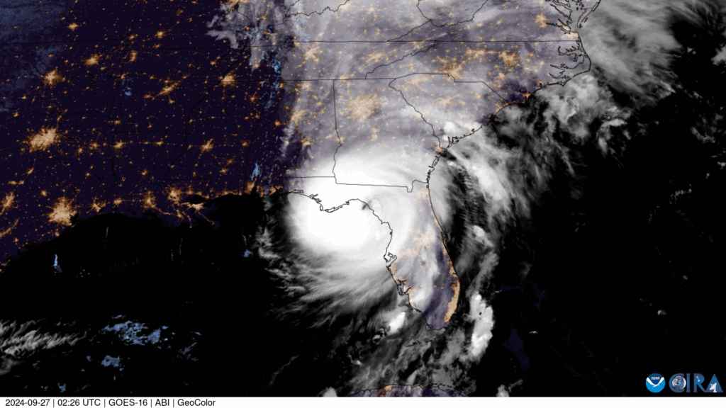
Hurricane Helene made landfall in Florida’s Big Bend region as a Category 4 hurricane on September 26, 2024. As usual, most people expected the greatest impacts to be near the coast from storm surge and wind damage. Instead, some of the worst destruction occurred hundreds of miles inland across North Carolina and Tennessee.
Summary
The deadliest impacts of Hurricane Helene began before the storm even reached U.S. soil.
Making landfall as a Category 4 hurricane (140 mph winds and a minimum pressure of 939 mb), Helene was the strongest landfalling hurricane in the Florida Big Bend region in recorded history. Before the storm made landfall, a Predecessor Rainfall Event (PRE) developed over the southern Appalachians, which is a period of extreme, heavy precipitation that occurs hundreds of miles ahead of a landfalling tropical cyclone. With Helene, this occurred when tropical moisture was pulled inland ahead of the storm and interacted with a stationary front over the Appalachians, producing double-digit rainfall totals over parts of North Carolina, Tennessee, and surrounding areas before the hurricane even made landfall in Florida.
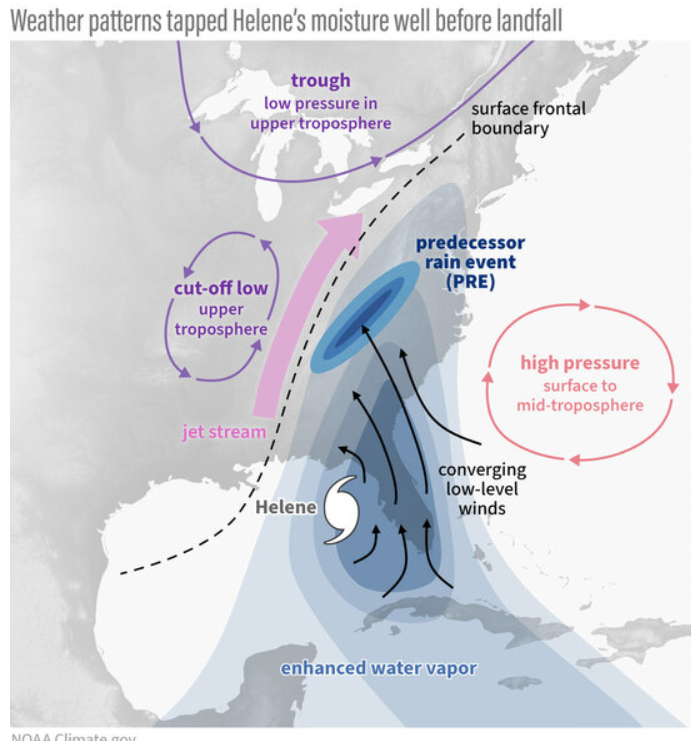
This extreme rainfall event was already catastrophic for the area, causing numerous landslides, soaking the soil, raising rivers and streams, and flooding the region all before the storm even arrived. With Helene moving into an already damaged and wet environment, faster runoff and greater flash flood potential was already a risk for the area.
Landfall
On September 26, 2024, Hurricane Helene made landfall about 10 miles Southwest of Perry, Florida. The nation prepared for the worst, but nobody knew exactly what was coming. The storm did numbers to the Florida Panhandle and Georgia, bringing catastrophic storm surges, massive power outages, destructive winds, and killing 71 people. The agricultural sectors in both states also suffered hundreds of millions in losses. Normally, this is the peak of a storm’s impact, but for Helene it was only the beginning.
As the storm moved inland towards the mountains, Helene’s rapid motion allowed for the storm to stay organized and transport tropical moisture far inland, causing orographic lifting to occur. Strong southerly winds forced air upslope into the mountains, where it expanded and cooled adiabatically, creating heavy rainfall that the previously saturated soils could no longer absorb. The result of this was extraordinary rainfall rates over already soaked soil, creating historically catastrophic flooding that changed the Appalachian region as we know it.
Transition into an Extratropical System
As Helene continued northward on September 27–28, it began to encounter cooler air and move away from it’s main power source, the Gulf. At the same time, an approaching upper-level trough started to absorb the storm, causing it to lose its tropical characteristics in a process known as extratropical transition. While Helene was no longer a hurricane by this stage, it continued to produce heavy rainfall across parts of the Appalachian Mountains. Eventually, the storm merged with a larger weather system and dissipated, but not before leaving behind historic flooding and widespread damage across the region.
Impacts
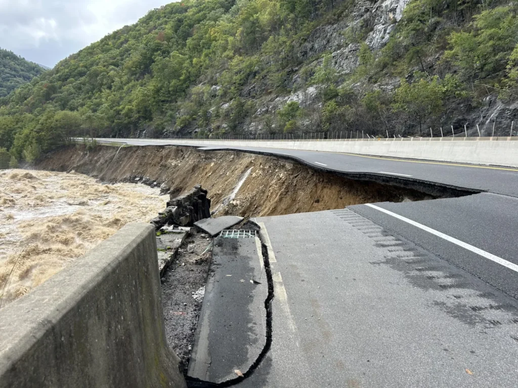
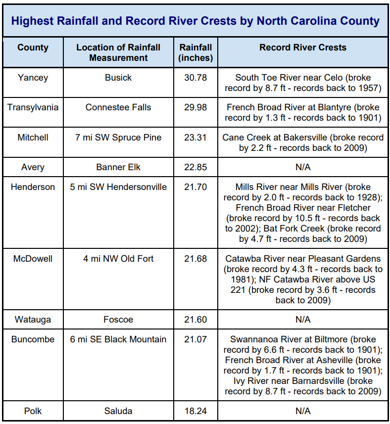
The destruction from this storm was catastrophic and widespread, impacting Cuba all the way up to the Ohio Valley. Rainfall amounts of 20 to 30 inches occurred over a large area within the mountainous region of western North Carolina, with the highest observed rainfall totaling just over 31 inches in Busick, North Carolina. This extreme rainfall combined with the steep terrain and saturated soils triggered approximately 2,015 landslides across the southern Appalachians. Roads, bridges, and critical infrastructure were washed away, isolating communities and disrupting power, water, and communication services. Helene demonstrated how tropical cyclones can become even more destructive inland when interacting with mountainous terrain and already vulnerable landscapes.
Take a look at this interactive preliminary Helene rainfall map from the NOAA GeoPlatform: https://noaa.hub.arcgis.com/maps/noaa::helene-rainfall-map/about
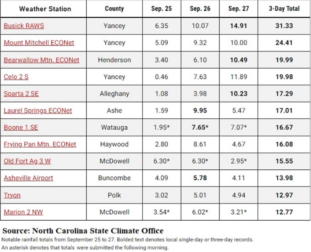
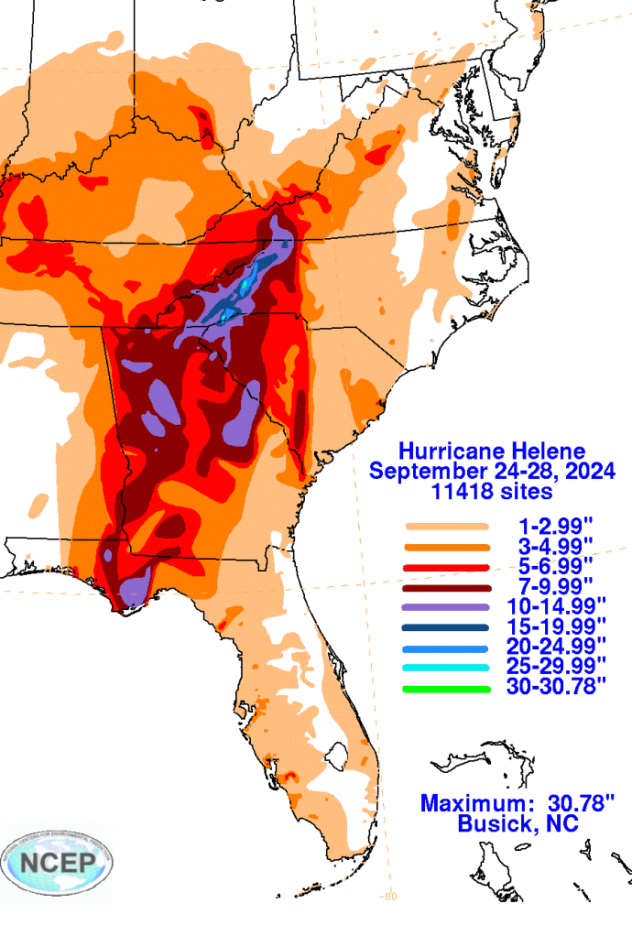
With much of the Appalachian region receiving at least 20″ of rainfall and isolated pockets of around 30″, much of the precipitation after the PRE could not infiltrate the soil and became runoff. With this runoff occurring through the Smoky Mountains, steep slopes, narrow valleys, and fast-responding watersheds led to historic river flooding. As this water moved rapidly downhill, the ground on the hillsides and mountains became very unstable and triggered over 2,000 landslides. This water and debris would then continue to travel to the “low points” in river valleys between the mountains. This led to record-breaking river crests and streamflow levels, and unfortunately, severe flooding for riverside communities.
The inland impact from Hurricane Helene was something that no one could have ever imagined. “The mountain hurricane” or ” the storm that rained miles” are ways NC/TN locals described this storm to me when I was visiting earlier this year. I had the pleasure of visiting the town of Hot Springs, North Carolina, among with many others while on a trip to the Smokies this past spring, and seeing the remaining damage almost two years after this storm is heartbreaking. These small mountain towns were unprepared and had never expected impacts like this from a hurricane that had us all worried for the Florida Gulf Coast. The Appalachian region will truly never be the way it was before this storm, and the story of ” the mountain hurricane” will continue to be passed down and remembered forever.
Works Cited
Hagen, Andrew, et al. Hurricane Helene. 8 Apr. 2025.
Thiem, Haley, and Rebecca Lindsey. “Hurricane Helene’s Extreme Rainfall and Catastrophic Inland Flooding.” NOAA Climate.gov, 7 Nov. 2024, www.climate.gov/news-features/event-tracker/hurricane-helenes-extreme-rainfall-and-catastrophic-inland-flooding. Accessed 13 June 2026.


