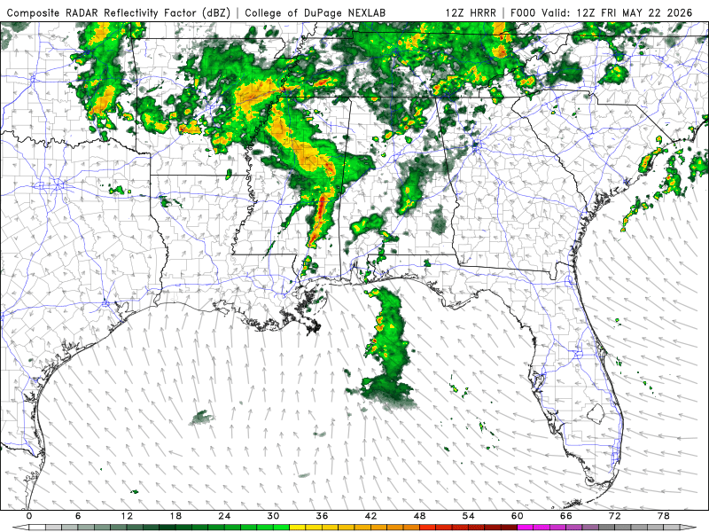
Current Conditions
We are experiencing rain and scattered thunderstorms, especially in Lower LA, MS, and AL. Make sure to keep an eye out for your area for any active alerts. Right now, Mobile County is seeing strong thunderstorms with flash flood warnings North-Northwest of the city. North of Birmingham, AL, and Huntsville, AL, are also seeing severe thunderstorms, with flood watches in effect.
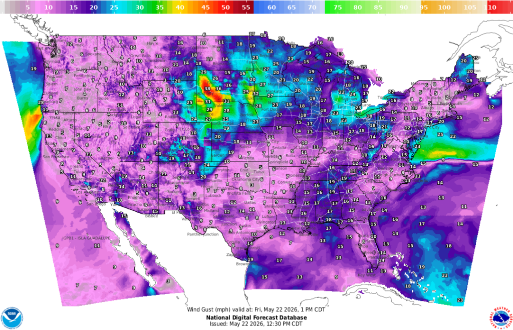
Wind speeds are averaging around 10mph throughout the region, with gusts up to the mid-20s in areas around Lower AL and the Florida Panhandle.
Later Today Into Tomorrow
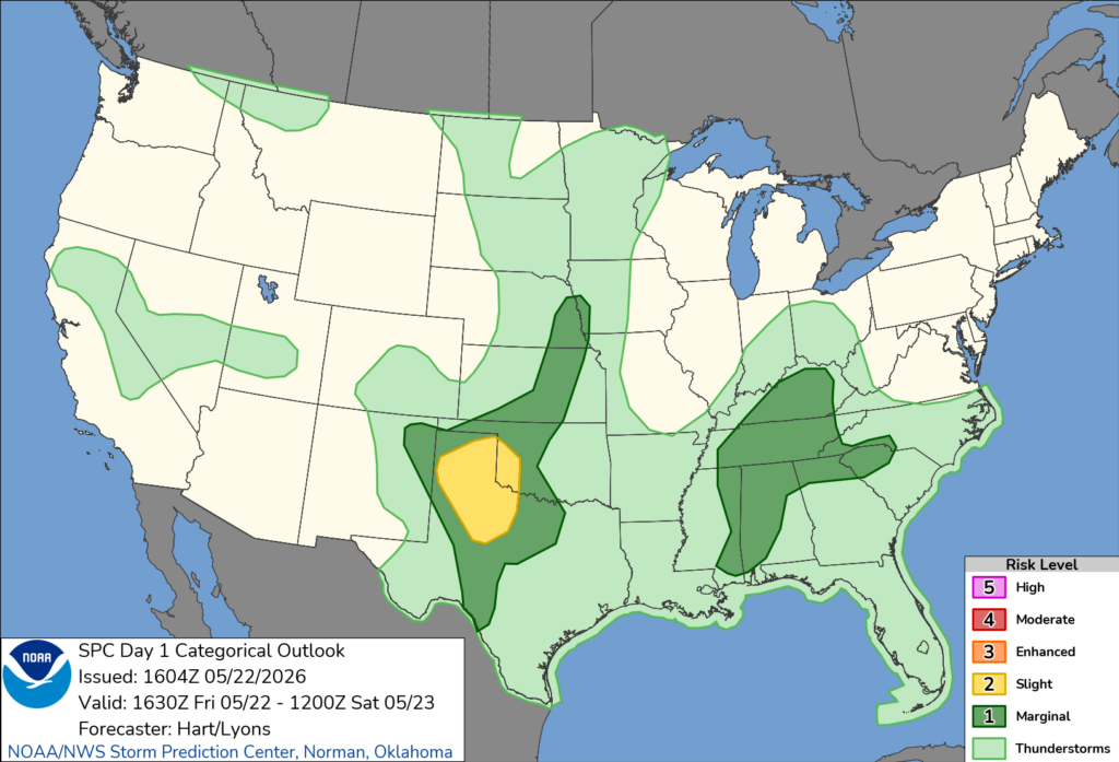
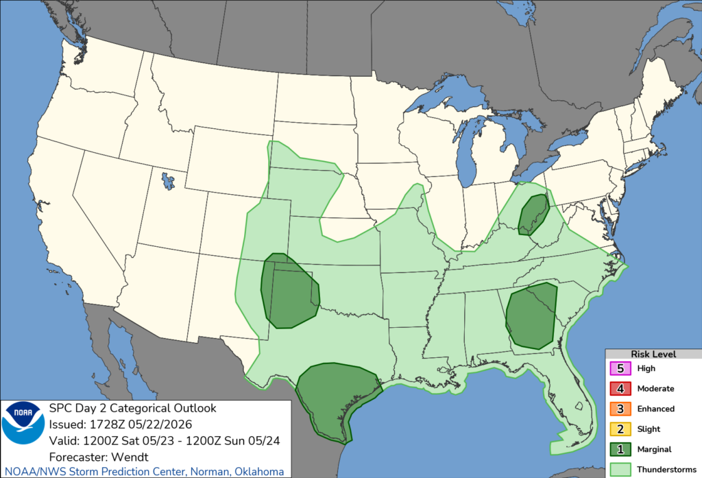
The SPC has our region in mostly general thunderstorms with parts of MS, GA, and most of AL under a 1/5 marginal risk. This means we could see hail or a few tornadoes from storms. By tomorrow, the marginal risk expires.
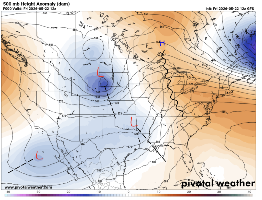
What’s With All This Rain?
If we take a look at the middle level of our atmosphere, we can see why our region is experiencing rain and scattered thunderstorms. We are sitting in an area of low-pressure with south-southwesterly prevailing winds.
Extended Regional Outlook
Over the course of a week or so, our temperatures will be pretty normal Summer conditions, except in most of Florida. Their temperatures will be looking above normal. Most of our region will be looking at above normal conditions in terms of precipitation.


Traveling Forecast (as of this evening)
KHOU – Houston: Partly cloudy with temperatures at 89°. Winds are S 13 mph. Humidity is at 52% with a dew point of 69°. The visibility is 10 miles.
KSHV – Shreveport: Thunderstorms with temperatures at 86°. Winds are W 7 mph. Humidity is at 62% with a dew point of 72°. The visibility is 10 miles.
KBTR – Baton Rouge: Thunderstorms with temperatures at 75°. Winds are W 8 mph. Humidity is at 67% with a dew point of 72°. The visibility is 10 miles.
KMSY – New Orleans: Thunderstorms with temperatures at 78°. Winds are SE 15 mph G 21 mph. Humidity is at 79% with a dew point of 71°. The visibility is 10 miles.
KJAN – Jackson: Partly cloudy with temperatures at 84°. Winds are W 5 mph. Humidity is at 61% with a dew point of 69°. The visibility is 10 miles.
KBHM – Birmingham: Overcast with temperatures at 74°. Winds are S 18 mph G 29 mph. Humidity is at 85% with a dew point of 69°. The visibility is 10 miles.
KMOB – Mobile: Partly cloudy with temperatures at 76°. Winds are W 3 mph. Humidity is at 85% with a dew point of 71°. The visibility is 10 miles.
KATL – Atlanta: Overcast with temperatures at 77°. Winds are S 10 mph. Humidity is at 71% with a dew point of 67°. The visibility is 10 miles.
KTLH – Tallahassee: Partly cloudy with temperatures at 87°. Winds are S 14 mph. Humidity is at 59% with a dew point of 71°. The visibility is 10 miles.
I-10: Showers and scattered thunderstorms, especially through LA, MS, and AL. Some pop-ups in West FL.
I-20: Scattered showers stretching across most of the interstate. Possible scattered thunderstorms.
I-49: Possible pop-up showers and thunderstorms in the late hours.
I-55 and I-59: Showers and scattered thunderstorms. Winds could reach the lower 10s mph.
I-65: Showers and scattered thunderstorms stretching across the interstate. Winds could reach the mid-10s mph.
I-75: Showers and scattered thunderstorms, especially in GA during the nighttime and morning hours. Winds around 5-10 mph.
3 Day City Forecast (as of this evening)
Houston, TX: Today’s high is mid-80s and low of mid-70s. Thunderstorm chances are 40% and 30% into the nighttime hours. Winds around 5 mph coming from the south-southeast. Saturdays’s high is mid-80s and low of lower 70s. Thunderstorm chances are possible throughout the day with a precipitation chances of 80%. Winds around 5 mph coming from the south then northeast into the next morning. Sunday’s high is lower 80s and low of lower 70s. Rain is likely and thunderstorms are possible throughout the day with a precipitation chance of 70%. Winds around 5 mph coming from the east.
Shreveport, LA: Today’s high is mid-80s and low of upper 60s. Thunderstorm chances are 40% and 30% into the nighttime hours. Winds around 5 mph coming from the west. Saturdays’s high is mid-80s and low of upper 60s. Thunderstorm chances at 40% with 60% chances of precipitation throughout the day, then 40% chance of thunderstorms and 80% of precipitation during the nighttime hours. Winds around 5 mph coming from the south . Sunday’s high is lower 80s and low of upper 60s. Precipitation chance of 80% throughout the day, then 40% chance of thunderstorms and 50% chance of precipitation during the nighttime hours . Winds around 5 mph coming from the northeast.
Baton Rouge, LA: Today’s high is lower 80s and low of lower 70s. Thunderstorm chances are 50% and 30% into the nighttime hours. Winds around 5 mph coming from the southwest. Saturdays’s high is mid-80s and low of lower 70s. Thunderstorm chances at 40% with 70% chances of precipitation throughout the day, then 70% chance of precipitation during the nighttime hours. Winds around 5 mph coming from the south-southwest. Sunday’s high is upper 70s and low of lower 70s. Thunderstorm chances at 100% with 90% chances of precipitation throughout the day, then 80% chance of precipitation during the nighttime hours. Winds around 5 mph coming from the south-southeast.
New Orleans, LA: Today’s high is mid-80s and low of mid-70s. Thunderstorm chances are 60% and 30% into the nighttime hours. Winds around 5 mph coming from the southwest. Saturdays’s high is mid-80s and low of lower 70s. Thunderstorm chances at 30% and increasing to 60% throughout the day, then 40% chance during the nighttime hours. Winds around 5 mph coming from the southeast. Sunday’s high is low 80s and low of mid-70s. Thunderstorm chances at 90% with 90% chances of precipitation throughout the day, then 80% chance of precipitation during the nighttime hours. Winds around 5 mph coming from the southeast.
Jackson, MS: Today’s high is lower 80s and low of mid-60s. Thunderstorm chances are 50% and 40% into the nighttime hours. Winds around 5 mph coming from the west-southwest. Saturdays’s high is mid-80s and low of upper 60s. 60% chances of precipitation throughout the day, then 40% chance of thunderstorms during the nighttime hours with a 60% of precipitation. Winds around 5 mph coming from the southwest. Sunday’s high is low 80s and low of upper 60s. Thunderstorm chances at 100% with 70% chances of precipitation throughout the day, then 80% chance of precipitation during the nighttime hours with a 70% of thunderstorms. Winds around 5 mph coming from the south.
Birmingham, AL: Today’s high is mid-70s and low of upper 60s. Thunderstorm chances are 30% and 40% into the nighttime hours. Winds around 5-10 mph coming from the south, gusts up to 20 mph. Saturdays’s high is lower 80s and low of mid-60s. Thunderstorm chances at 60% throughout the day, then 60% chance of thunderstorms during the nighttime hours. Winds around 5 mph coming from the south. Sunday’s high is lower 80s and low of mid-60s. 50% to 90% chance of precipitation throughout the day, then 80% chance of precipitation during the nighttime hours. Winds around 5 mph coming from the south.
Mobile, AL: Today’s high is lower 70s and low of lower 70s. Thunderstorm chances are 50% and 50% into the nighttime hours. Winds around 10 mph coming from the south. Saturdays’s high is mid-80s and low of lower 70s. 70% chances of precipitation throughout the day, then 20% chance of thunderstorms during the nighttime hours with a 30% of precipitation. Winds around 5 mph coming from the south. Sunday’s high is mid-80s and low of low 70s. 80% chances of precipitation throughout the day, then 70% chance of precipitation during the nighttime hours with a 40% of thunderstorms. Winds around 5-10 mph coming from the southeast.
Atlanta, GA: Today’s high is upper 70s and low of upper 60s. Thunderstorm chances are 80% and 70% into the nighttime hours. Precipitation throughout the night is very likely. Winds around 5-10 mph coming from the south. Gust up to 15 mph. Saturdays’s high is lower 80s and low of mid-60s. 90% chances of precipitation throughout the day with a 70% chance of thunderstorms, then 70% chance of precipitation during the nighttime hours. Winds around 5 mph coming from the south. Sunday’s high is lower 80s and low of upper 60s. 50 to an 80% chance of precipitation throughout the day, then 80% chance of precipitation during the nighttime hours. Winds around 5 mph coming from the south.
Tallahassee, FL: Today’s high is upper 80s and low of lower 70s. Mostly cloudy during the nighttime hours. Winds around 5 to 10 mph coming from the south-southeast. Saturdays’s high is upper 80s and low of lower 70s. 50% chance thunderstorms throughout the day, then 10% chance of thunderstorms during the nighttime hours. Winds around 5 mph coming from the south. Sunday’s high is low 90s and low of low 70s. Thunderstorm chances at 40% throughout the day, then 20% chance of precipitation during the nighttime hours with a 30% of thunderstorms. Winds around 5 mph coming from the south.
A Driving Heads Up
If you have to drive in rainy conditions today or this Memorial Day weekend, make sure to drive carefully, avoid cruise control, try to drive on the same path as other vehicles, and don’t make sudden movements. Following these directions will lower your chances of hydroplaning.
If you are hydroplaning, here are some things you can do to get yourself back on track: try not to panic, slow down by easing off the gas, not braking, turn your wheel in the direction your car is beginning to spin, and try not to make any quick movements with the steering wheel. This will only cause more unrest with the car.


