
After the cold front’s passing yesterday, we’re in the clear with a few days of peaceful, drier weather. A strong high pressure system will drape over us for a few days keeping us warm and dry until near the end of the week.

Unfortunately, this dry weather is not to last as we have another front moving our way around Wednesday into Thursday. A weak subtropical jet will form in the northwestern Gulf, moving towards Louisiana all the way to Florida with some moisture flow and some possible rain closest to the coastline. From the mid-levels, a trough will form out in the southwestern US and find its feet towards the weekend as it moves a disturbance towards the mid-South. A long surface low is trying to push its way towards the high pressure system that was once over us, however will slow down as it reaches the southeast.

What a stalled front usually means for us is rain, and lots of it. This will be a multi-day event with rain and thunderstorms bringing in a few rounds during the day and overnight. Considering the potency and Precipitable Water reaching close to 2 inches across the deep south, we’re definitely in the range of flash flooding and even some river flooding.
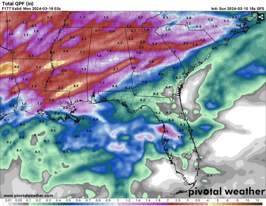
Rainfall totals on average look to be around 2-4 inches with some areas receiving more depending on the storms. Along with this, I wouldn’t be surprised if we get a few strong to severe storms especially over the weekend as the front moves over us. The SPC has already placed an outlook for Thursday in eastern Texas to Louisiana and Arkansas.
The rainy weather will likely begin late Wednesday and start some of the highest rainfall totals by Friday as the front moves in. More rain and thunderstorms will be possible Saturday into Sunday and may continue overnight into Monday. Stay tuned as we get closer to the middle of the week for updates on the forecast and any possible severe weather associated with this next system.
[wpcode id=”41179″]
Regional Day-to-Day Forecast
Tonight – Partly cloudy, with a low in the low 40s. North northwest wind around 5 mph becoming calm.
Monday – Partly sunny, with a high in the mid 60s. East northeast wind around 5 mph.
Monday Night – Mostly clear, with a low around 40. Calm wind.
Tuesday – Mostly sunny, with a high in the low 70s. Calm wind becoming south around 5 mph in the afternoon.
Tuesday NightPartly cloudy, with a low in the upper 40s. South wind around 5 mph.
Wednesday – Partly sunny, with a high in the mid 70s. South wind 5 to 10 mph.
Wednesday Night – Partly cloudy, with a low in the mid 50s. South southeast wind 5 to 10 mph.
Thursday – A 50 percent chance of showers and thunderstorms in the afternoon. Mostly cloudy, with a high in the upper 70s. South southeast wind 5 to 10 mph, with gusts as high as 20 mph.
Thursday Night – A 50 percent chance of showers and thunderstorms. Mostly cloudy, with a low in the mid 60s. South southeast wind around 10 mph, with gusts as high as 20 mph.
Friday – Showers and possibly a thunderstorm. High in the upper 70s. Chance of precipitation is 80%.
Friday Night – Showers and thunderstorms likely. Mostly cloudy, with a low in the low 60s. Chance of precipitation is 60%.
Saturday – A 50 percent chance of showers and thunderstorms. Partly sunny, with a high in the upper 70s.
Saturday NightA 40 percent chance of showers and thunderstorms. Mostly cloudy, with a low in the mid 50s.
Sunday – A 30 percent chance of showers and thunderstorms. Mostly sunny, with a high near 70.
[wpcode id=”41149″]


