Starting today, calm and dry weather takes over as high pressure keeps things quiet for the next day or two. Despite a chilly start this morning, temperatures will rise quickly thanks to the dry air.
Temperatures will be on a warming trend all week with a good southerly flow.Then by later this week – with instability in place – we will see another shot for rain and storms.
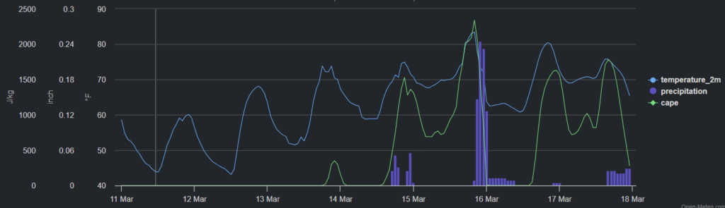
The next shot for rain arrives on Wednesday. Sort of. There will be a chance for rain, but I don’t think it will be very robust, widespread or organized. Then, things get a bit more active as we close out the week and head into the weekend.
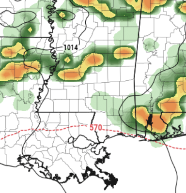
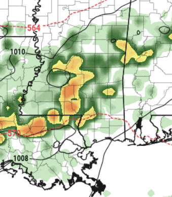
Thursday night into Friday morning, we’re looking at the potential for severe storms and flash flooding. This might even continue until Sunday evening when a cold front passes through. The images above show a snapshot of the estimated radar for the EXMWF model for Thursday and into Friday and then again on Saturday night.
As for Thursday through Saturday, Thursday night into Friday morning brings the possibility of severe storms, potentially including hail and even tornadoes in the early hours of Friday. Flash flooding could also occur due to heavy rainfall. Saturday night brings another round of storms, but mainly to areas south of I-20. These storms could bring strong winds and hail, once again posing a risk of flash flooding.
Looking ahead to early next week, expect a return to cool and dry conditions, with a chance of frost in some northern areas. While there’s still some uncertainty, it seems like we’ll see a break from the active weather after this stretch.
REGIONAL DAY TO DAY FORECAST
Today: Mostly cloudy this morning, then becoming partly sunny. Highs in the upper 60s. Northeast winds around 5 mph.
Tonight: Mostly clear. Lows in the lower 40s. Light and variable winds.
Tuesday: Mostly sunny. Highs in the mid 70s. East winds around 5 mph, becoming south around 5 mph in the afternoon.
Tuesday Night: Partly cloudy in the evening, then becoming mostly cloudy. Lows in the upper 40s. South winds around 5 mph.
Wednesday: Partly sunny with a stray shower possible. Highs in the upper 70s. Southeast winds around 5 mph. Chance for rain 10 percent.
Wednesday Night: Mostly clear in the evening, then becoming partly cloudy. Lows in the mid 50s.
Thursday: Partly sunny in the morning, then mostly cloudy with a chance of showers with a slight chance of thunderstorms in the afternoon. Highs in the upper 70s. Chance of rain 40 percent.
Thursday Night: Mostly cloudy with a slight chance of thunderstorms. A chance of showers. Lows in the mid 60s. Chance of rain 40 percent.
Friday: Mostly cloudy with a slight chance of thunderstorms. A chance of showers in the morning, then showers likely in the afternoon. Highs in the upper 70s. Chance of rain 70 percent.
Friday Night: Mostly cloudy with a slight chance of thunderstorms. A chance of showers. Lows in the lower 60s. Chance of rain 30 percent.
Saturday: Mostly cloudy in the morning, then becoming partly sunny. A slight chance of thunderstorms. A chance of showers. Highs in the upper 70s. Chance of rain 60 percent.
Saturday Night: Mostly cloudy with a chance of showers with a slight chance of thunderstorms. Lows around 60. Chance of rain 40 percent.
Sunday: Partly sunny with a chance of showers with a slight chance of thunderstorms. Highs in the mid 70s. Chance of rain 30 percent.


