No major changes to the forecast this morning, but we are starting to get a better idea about how things are going to chaske out as we move through the end of the week and into next week.
It looks like we will have multiple rounds of showers and storms as we move from Thursday night through Monday morning. Each round will have the chance to produce strong storms with a few shots for some severe weather, too.
Here is an animation of the handful of weather systems set to blow through during the next 10 days
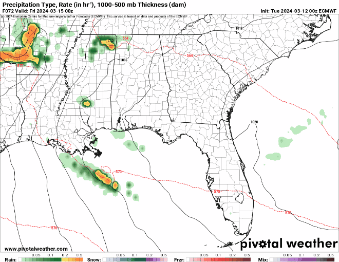
While I recognize the animation moves quickly and it is tough to see – specifically – when the rain my pass over any one given point, I think one take-away here is that it wont be a total washout and there will be breaks here and there between any rain.
Also, I don’t think we will have a chance for tornadoes with each round of storms, but I think there will be windows in there where it is more likely than other times. It looks like Thursday evening and Sunday morning may feature the highest risk for tornadoes while FRiday and Saturday may feature better shot for hail and strong wind.
But things are still open for some shifting. So please continue to keep up with the weather forecast int eh coming days.
REGIONAL DAY TO DAY FORECAST
Today: Mostly sunny. Highs in the lower 70s. East winds around 5 mph, becoming south around 5 mph this afternoon.
Tonight: Partly cloudy. Not as cool with lows in the upper 40s. South winds around 5 mph in the evening, becoming light and variable.
Wednesday: Partly sunny. Highs in the mid 70s. Southeast winds 5 to 10 mph.
Wednesday Night: Mostly clear in the evening, then becoming partly cloudy. Lows in the upper 50s. Southeast winds around 5 mph.
Thursday: Partly sunny in the morning, then becoming mostly cloudy. A slight chance of thunderstorms. A slight chance of showers in the morning, then a chance of showers in the afternoon. Highs in the upper 70s. Southeast winds 10 to 15 mph with gusts up to 25 mph. Chance of rain 40 percent.
Thursday Night: Mostly cloudy with a slight chance of thunderstorms. A slight chance of showers in the evening, then a chance of showers after midnight. Lows in the mid 60s. Chance of rain 40 percent.
Friday: Mostly cloudy with a slight chance of thunderstorms. A chance of showers in the morning, then showers likely in the afternoon. Highs around 80. Chance of rain 70 percent.
Friday Night: Mostly cloudy with a chance of showers with a slight chance of thunderstorms. Lows in the mid 60s. Chance of rain 40 percent.
Saturday: Mostly cloudy in the morning, then becoming partly sunny. A slight chance of thunderstorms. A slight chance of showers in the morning, then a chance of showers in the afternoon. Highs in the lower 80s. Chance of rain 40 percent.
Saturday Night: Mostly cloudy with a chance of showers with a slight chance of thunderstorms. Lows in the mid 60s. Chance of rain 50 percent.
Sunday: Showers likely with a slight chance of thunderstorms. Highs in the mid 70s. Chance of rain 70 percent.
Sunday Night: Mostly cloudy with a slight chance of thunderstorms. A chance of showers, mainly in the evening. Cooler with lows in the lower 50s. Chance of rain 30 percent.
Monday: Partly sunny. A slight chance of showers and thunderstorms in the morning. Highs in the upper 60s. Chance of rain 20 percent.


I know you addressed this in your comments but I wish you could slow down the animation loop a little bit.