If you’ve been wondering where the real fall weather was going to hit, it’s finally making its way to the Pine belt starting next week! Temperatures will be much cooler than we’ve had for the past couple of weeks and we may even see temperatures down into the 30s by Wednesday night.
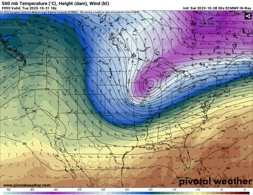
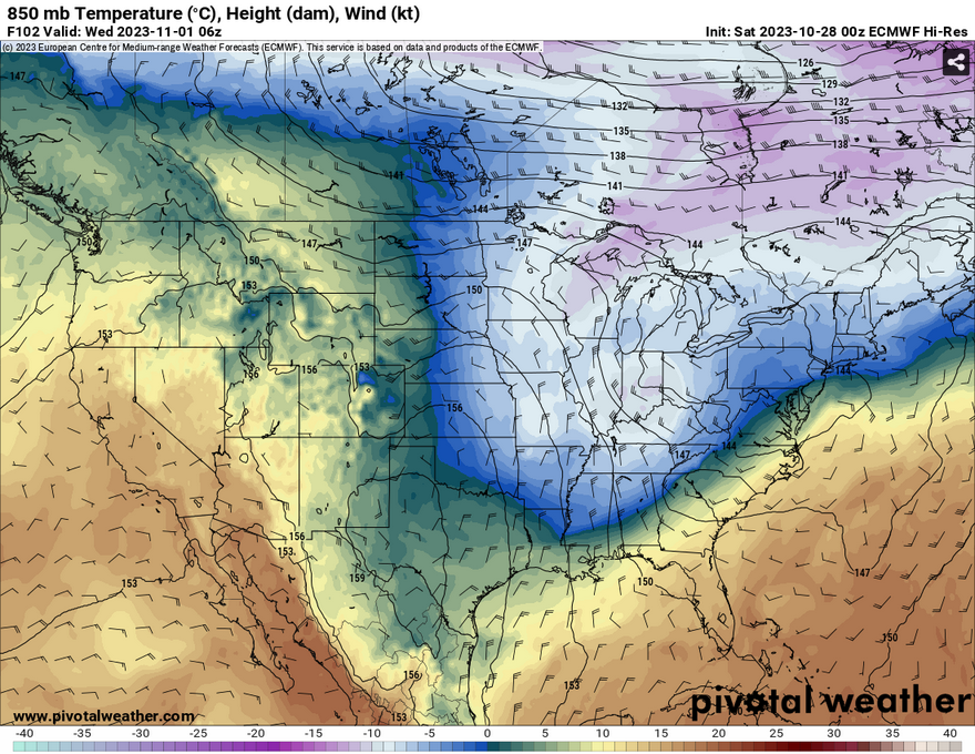
Looking at the upper levels, we see that that the subtropical ridge is going to breakdown by the beginning of next week. This will make room for the aforementioned cold front that will be here by late Monday into Tuesday. Later into the week looking at the 850mb level, we see that there’s another wave of cold air that will push through into the South by Thursday.

Looking at the difference in temperatures, will likely be going from the mid 80s like this weekend into the uppers 50s and 60s by Tuesday. Low temperatures will dip down into the 40s and possibly even into the 30s. Looking at the second cold front, our main concern depending on where it may happen, temperatures could reach the freezing point on Wednesday night. Despite this, in the latter part of the week, temperatures will slowly start to climb from the 60s to the 70s by the weekend.

Now looking at the first cold front from Monday night into Tuesday, there is a slight, and I mean slight chance of rain in the picture. Because of the pervading high pressure system over us currently, this will likely squeeze out any big chance of rain that we would normally get with a cold front and unfortunately leaves us with not a lot of rain overall. The Euro model suggests about a tenth to maybe 1/4 an inch of rain, however this looks like the best case scenario. It’s nothing significant, and unfortunately we stay dry all the way in to the weekend.
While the freezing temperatures are still a bit up in the air (no pun intended), it may not be a bad idea to take some precautions for next week. It’ll be quite windy which means that it’s time to bring out the jackets again and also cover your head and ears especially at night. Wind gusts are expected to hit around 25 miles an hour for a few days considering the strength of this cold front.
[wpcode id=”41179″]
Regional Day-to-Day Forecast
Today – Sunny, with a high near 84. Calm wind becoming southeast around 5 mph in the afternoon.
Tonight – Patchy fog before sunrise. Otherwise, increasing clouds, with a low around 61. South southeast wind around 5 mph becoming calm.
Sunday – Patchy dense fog in the morning. Otherwise, mostly cloudy, then gradually becoming sunny, with a high near 85. Calm wind becoming south southeast around 5 mph in the morning.
Sunday Night – Patchy fog after 3am. Otherwise, increasing clouds, with a low around 62. South southeast wind around 5 mph becoming calm after midnight.
Monday – Areas of fog before 9am. Otherwise, mostly sunny, with a high near 79. Light north wind becoming north northwest 5 to 10 mph in the morning.
Monday Night – A 20 percent chance of showers. Mostly cloudy, with a low around 49. North wind around 15 mph, with gusts as high as 20 mph.
Tuesday – Partly sunny, with a high near 60. North wind around 15 mph, with gusts as high as 25 mph.
Tuesday Night – Mostly clear, with a low around 38. North wind around 15 mph, with gusts as high as 25 mph.
Wednesday – Sunny, with a high near 58. North wind around 15 mph, with gusts as high as 25 mph.
Wednesday Night – Clear, with a low around 34.
Thursday – Sunny, with a high near 65.
Thursday Night – Mostly clear, with a low around 38.
Friday – Sunny, with a high near 70.
[wpcode id=”41149″]


