
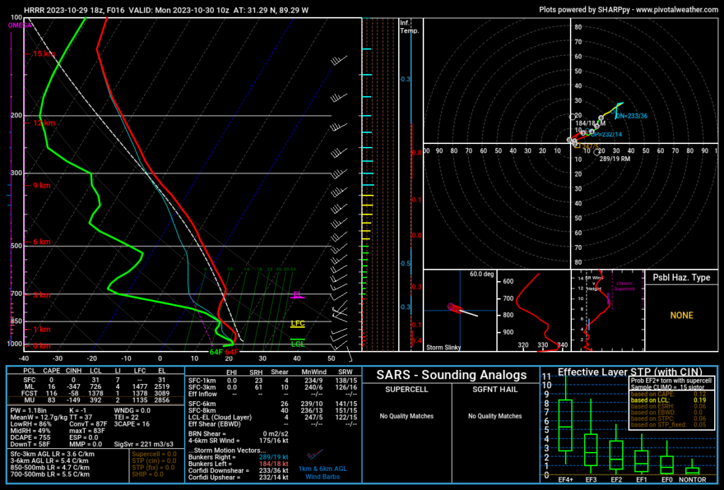
The cold front looks to arrive overnight but not before we have some dense fog in the Pinebelt. The National Weather Service in Jackson has issued a Dense Fog Advisory from Brookhaven to Meridian. Looking at the Skew-T, we’ll see low level clouds develop around midnight. Afterwards, the surface becomes saturated and some dense fog will creep in and last for the rest of the night until after sunrise. If you’re driving, please slow down, use your low beams and stay aware of your surroundings.
Into the daytime, with the cold front expected to arrive in the morning, this will likely mitigate temperatures. Temperatures may fall a bit after the morning and remain around the same during the rest of the day. So far, the HRRR model is looking at temperatures to stay in the upper 60s but low 70s may be possible. Low temperatures will drop into the 40s Monday night.

Rain chances look isolated to scattered with most of the rain staying in the Delta and west central Mississippi. There may be a few showers that land in the evening, but with the rain coming in behind the front and with our already drier than normal conditions, we may not see much at all by the end of the day.
Keep a jacket ready for the windy weather as we’ll see plenty of wind gusts associated with the front!
[wpcode id=”41179″]
Regional Day-to-Day Forecast
Tonight – Patchy dense fog after midnight. Otherwise, increasing clouds, with a low around 64. South wind around 5 mph becoming calm after midnight.
Monday – Areas of dense fog before in the morning. Otherwise, mostly cloudy, with a high near 70. North northwest wind 5 to 15 mph, with gusts as high as 20 mph.
Monday Night – A 30 percent chance of rain in the evening. Mostly cloudy, with a low around 47. North wind 10 to 15 mph, with gusts as high as 20 mph.
Tuesday – Cloudy, then gradually becoming mostly sunny, with a high near 58. North wind 10 to 15 mph, with gusts as high as 25 mph.
Tuesday Night – Mostly clear, with a low around 35. North wind around 15 mph, with gusts as high as 25 mph.
Wednesday – Sunny, with a high near 57. North northeast wind around 15 mph, with gusts as high as 25 mph.
Wednesday Night – Areas of frost before sunrise. Otherwise, clear, with a low around 33. North northeast wind 5 to 10 mph becoming light northeast in the evening.
Thursday – Areas of frost in the morning. Otherwise, sunny, with a high near 65. Calm wind becoming east around 5 mph in the morning.
Thursday Night – Mostly clear, with a low around 36. East northeast wind around 5 mph becoming calm.
Friday – Sunny, with a high near 70.
Friday Night – Mostly clear, with a low around 43.
Saturday – Sunny, with a high near 76.
Saturday Night – Mostly clear, with a low around 49.
Sunday – Sunny, with a high near 76.
[wpcode id=”41149″]


