April 14 south Mississippi severe weather discussion
Author: Nick Lilja
|| Published: 4/13/2018 at 7:44am
We are still watching for a line of severe storms to pass through the Pine Belt during the day on Saturday. We are about to get pretty detailed and pretty nerdy. You’ll get a full explanation here. But if all you want is the down-and-dirty forecast, take a look at the map below and swipe/scroll down to the last few paragraphs in the section “Putting a pretty bow on it.”
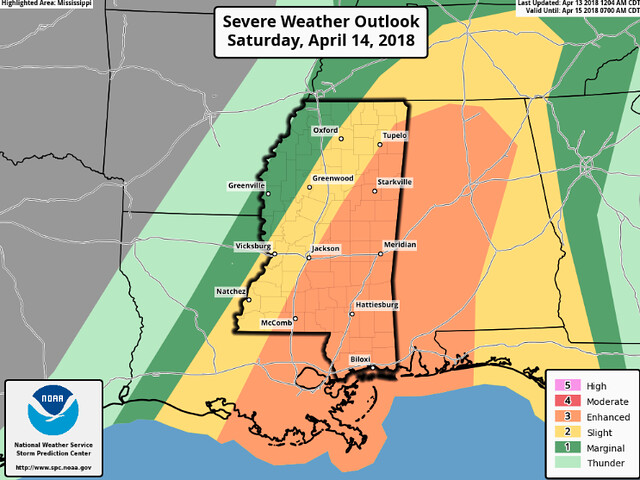
The Enhanced Risk for severe weather remains.
A secondary mid-level speed max should dig south-southeast into Mexico which should encourage height falls across the lower MS Valley region during the day. It’s not entirely clear whether a secondary, weaker surface low will evolve along the advancing cold front across LA/MS but it appears a wave should evolve which will encourage low-level convergence. Latest model guidance suggest a pronounced southerly LLJ will translate east across the Mid South and vertical shear profiles will be more than sufficient for organized long-lived updrafts. If boundary-layer heating is as pronounced as the NAM suggests over eastern MS/western AL a corridor of 2000+ J/kg SBCAPE could evolve ahead of the front. Large-scale forcing suggests considerable amount of frontal convection but isolated supercells could also develop ahead of the boundary. If discrete storms evolve the tornado threat would be greater than with the frontal squall line.
4/13/18 Storm Prediction Center Day 2 Severe Weather Risk
As the model data continues to come in, and the weather balloons across the country continue to sample the storm, we (meteorologists) are starting to get a better idea of what to expect.
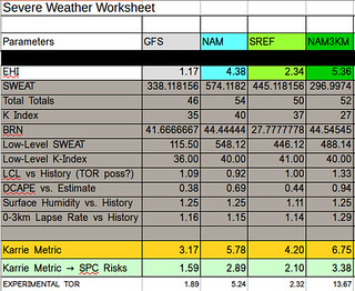
Karrie Meter
Almost unchanged since this morning. Now at a 4.97. That is expected, though.
Severe Weather Worksheet
While specifics about the threat levels has been difficult to nail down, the general background question of “will there be severe weather?” and “If so, what is the magnitude of severity?” has been pretty straight-forward.
The biggest problem has been the GFS computer weather model refusing to catch up to the other model guidance available. It continues to push rain through earlier in the day, with a weaker line and weaker storms. That is keeping the Karrie Meter lower.
This is the one time this year that we have felt pretty good about that side of the forecast, though. And while I hate to discount an entire model, I think it is struggling with this event.
It has been the timeline that, up until this point, has given us problems.
More on that below.
Expect rain
Regardless of the other threats, heavy rain and flash flooding are starting to be my main concern. This may not be life-threatening, evacuate a town kind of floods… But there may be enough rain to push local streams out of their banks and put water over the roads in some areas.
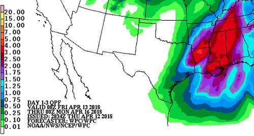
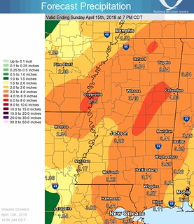
The Weather Prediction Center Forecast // Courtesy: noaa.gov
The Weather Prediction Center is forecasting for two-to-four inches of rain across the area with some areas receiving as much as five to six inches of rain.
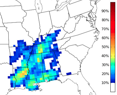
CIPS Analogs showing the percent-chance that historically similar setups have produce more than 2.5 inches of rain // Courtesy: CIPS Analogs
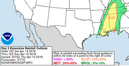
Because of that the WPC has also issued a Slight Risk for Excessive Rainfall. And Excessive Rainfall is classified as rainfall that would exceed Flash Flood guidance – meaning, in essence, the percent-chance of experiencing a flash flood.
4/12/18 Risk area from the WPC
If you have plans to travel on Saturday across South Mississippi, please plan to give yourself extra time to get where ever you are headed. And make sure you know alternative routes, in case one way ends up being covered by water.
Tell the kids to enjoy Prom
I know a lot of schools have Prom this Saturday night. The weather should move through most of the area by 7pm Saturday night. That means Prom shouldn’t be ruined by severe weather.
National Weather Service rainfall estimates // Courtesy: noaa.gov
However.
Since the rain may stick around after the severe weather departs, there will likely still be wet roads – and perhaps some roads under water – and tricky driving conditions. Please make sure your kids know the roads and urge them to not drive through flooded roads. Turn around, don’t drown.
That may mean giving the kids alternative routes to get home, or to a friends house, or to Prom itself.
Also.
I know the kids want to look their best, but if they are driving between picking up tuxes or dresses, or getting their hair done, or just hanging with friends during the day, please (PLEASE!) make sure they are aware of the weather.
Tornado threat is complicated
At face value, the NAM-3km sounding looks pretty scary.
Saturday afternoon Skew-T and forecast sounding information for the eastern sections of the Pine Belt // Courtesy: Pivotal Weather
Firstly, a special thanks to the guys at Pivotal Weather for access to such awesome data.
Secondly, I know seeing “PDS TOR” on there might scare some of you and confuse others. So I’d like to take a second to explain… To help everyone!
This is the short-hand explanation about how a PDS TOR ends up on the Pivotal Sounding from Sharppy from Lucas Reynolds (Twitter: @ljwxman116)
The PDS TOR stands for a “Particularly Dangerous Situation TORnado. This is used to identify an atmospheric profile capable of producing a tornado that was stronger than an EF-2 rating.
Put the research from those two papers together – with a few other research papers, too – and then dump all of the the math derived between them all into a program and BOOM! you have a way to identify the environment capable of producing a strong tornado.
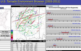
Tornado Environment Browser from the Storm Prediction Center shows that different values make tornadoes in South Mississippi
But there is a catch (at least for South Mississippi). Most of the research was done in Oklahoma and Texas. The numbers identified aren’t always the numbers it takes to produce a tornado in South Mississippi.
For example, in the image above noting that ML LCL >= 1200 -> Well for South Mississippi that needs to be closer to 600. The STP EFF and FIXED >=3 -> For South Mississippi as low as 0.7.
And because the parameters around here are different, that makes the “PDS TOR” part of that sounding information a little less meaningful.
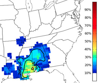
CIPS Analogs showing an up-to-45-percent chance that historically a similar atmospheric setup has produced at least one tornado report // Courtesy: CIPS Analogs
What does all of that have to do with our tornado threat? Well, it gets complicated because it is so easy for South Mississippi to get brief/weak tornadoes, it makes the overall “threat” for any one tornado to happen higher. But, because our parameters to get a strong tornado are a bit different, it gets difficult for us to identify the environment that may produce stronger tornadoes.
All of that being said, in this case and given the information I’ve seen, I can’t say there will “for sure” be a strong tornado, but sadly, the threat for an EF-2 or EF-3 tornado isn’t zero, either.
I know that isn’t the best forecast, but it is the best we can do. One way to look at it, though: Recent severe weather events I have specified that EF-0 and EF-1 tornadoes were possible, but EF-3 or stronger were not. And we have seen a few events with EF-0 and EF-1 tornadoes, but none stronger than EF-2.
Confused yet? If so, I apologize. It is quite the confusing forecast.
The Timeline
Simpson, Smith, Lawrence and Jeff Davis counties: Storms start around 7am
Jasper, Clarke, Covington, Jones and Wayne counties: Storms start around 11am
Marion, Lamar, Forrest, Perry, Greene counties: Storms start around 1pm
Pearl River, Stone, George counties: Storms start around 4pm
Depending on how storms line up during the day on Saturday, these times may change by an hour or two, but if you are making plans, this is a good ballpark for timing.
Storms start at 7am for the northern counties of South Mississippi, then linger int eh area until around 7pm. All modes of severe weather will be possible. That means watch out for heavy rain, flash flooding, frequent lightning, damaging wind gusts (up to 70mph), hail (up to the size of half-dollars) and the possibility of a tornado or two.
Identifying where the strongest of the storms may develop based on computer weather model guidance
Once the severe weather ends, rain and thunder may stick around for an additional few hours.
Author of the article:
Nick Lilja
Nick is former television meteorologist with stints in Amarillo and Hattiesburg. During his time in Hattiesburg, he was also an adjunct professor at the University of Southern Mississippi. He is a graduate of both Oregon State and Syracuse University that now calls Houston home. Now that he is retired from TV, he runs this site and its app in his spare time.