Now that Tropical Storm Bonnie has entered the Eastern Pacific and Tropical Storm Colin has dissipated, the Gulf of Mexico, Caribbean Sea, and Atlantic are currently quiet in terms of tropical activity. This lull in activity is expected to continue throughout the week, so long as there are no more surprises.

One clear reason to the Atlantic silence is 1) the Saharan African Layer (SAL), an area of very dry air that inhibits convective activity and will be traversing westward through the Atlantic over the next several days.
2) An area of thunderstorms associated with the Inter Tropical Convergence Zone (ITCZ) is producing heavy rainfall over and around Panama. These storms are currently more bark than bite and aren’t expected to develop into any tropical system.
3) Hurricane Bonnie continues to strengthen in the Eastern Pacific and will progress westward away from land. Bonnie is expected to remain a low-end hurricane as it moves through warm sea surface temperatures and tolerable wind shear.

Bonnie will experience moderate wind shear within the next 48 hours as it moves westward, eventually moving into a low-shear environment. Despite the shear, the storm is expected to retain its hurricane status and may continue to strengthen further down the line for reasons discussed in the next few paragraphs.

Bonnie is in a moist environment but will be pushing through dry air soon. This isn’t expected to affect the storm significantly over the next few days as its closed-circulation/sufficient organization will hinder dry air entrainment; however, computer models depict dry air entering into the circulation and weakening the hurricane by early Saturday.

To reiterate, Hurricane Bonnie is well-organized at the 850mb level (roughly one mile above the ocean). Notably its closed-circulation and strong cyclonic winds, helping draw up ample moisture/fuel from the warm ocean waters, and until this fuel supply is cut off, Bonnie will remain a hurricane in the Eastern Pacific.
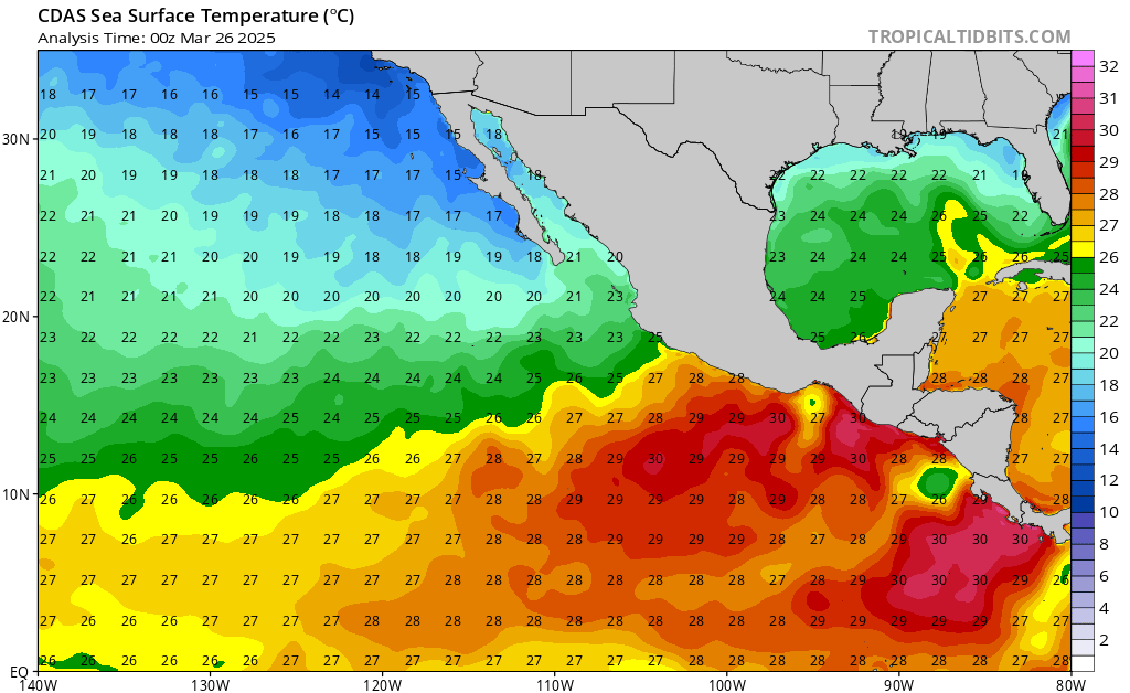
Sea surface temperatures (SSTs) in the Eastern Pacific are sufficiently warm and will supply the hurricane with all the energy it needs. Ideally, SSTs should exceed 26C in order for tropical systems to develop and for hurricanes to exist, and Bonnie will be feeding off of very favorable SSTs of 28C to 29C.

Despite the moderate wind shear and dry air, Bonnie’s well-organized structure and the warm SSTs it will be experiencing will allow for the Hurricane to maintain its strength and possibly strengthen over the next few days, eventually weakening by Saturday as depicted by the majority of the computer models in the above image.

The National Hurricane Center is working hard by monitoring Hurricane Bonnie in the Eastern Pacific. No hurricane watches or warnings have been issued at this time as the storm is expected to move westward and away from land. The only impact that Bonnie may have to land is if it creates strong enough swells to reach the Pacific Coast. These swells can generate great waves for surfers, but also create dangerous rip currents, so make sure to check your local Surf Forecasts from the National Weather Service if swimming in the ocean.


