Things are looking pretty good for today and tomorrow. And even into Tuesday, too.
As I continue to poke around with the coding language Python, I will continue to work on creating my own weather maps. Here are the ‘weather maps’ for tomorrow morning:


And tomorrow afternoon:


Once we get beyond midweek, then things get a bit more interesting. But also, perhaps less interesting. I know that isn’t much of a forecast, but there is a unique ‘thing’ worth watching that may try to develop in the Gulf.
And before you get too concerned, I want to reassure folks that a ‘thing’ in the Gulf isn’t going to be much more than heavy rain and gusty wind – at worst – and not some sort of massive storm. It is also not a ‘sign of things to come’ as much as it is just a random event caused by a bit of a non-traditional weather pattern.
Looking at the maps, we can already see the area of interest. It is hanging off the coast of the Carolinas. This is one reason why I don’t think there is much cause for concern. We are going to watch a little bubble in the low-levels traverse back to the west around a ridge of high pressure from the East Coast to the Gulf Coast during the next few days. Thankfully, this isn’t a situation where some remnant low will be just ‘hanging around’ in the Gulf.

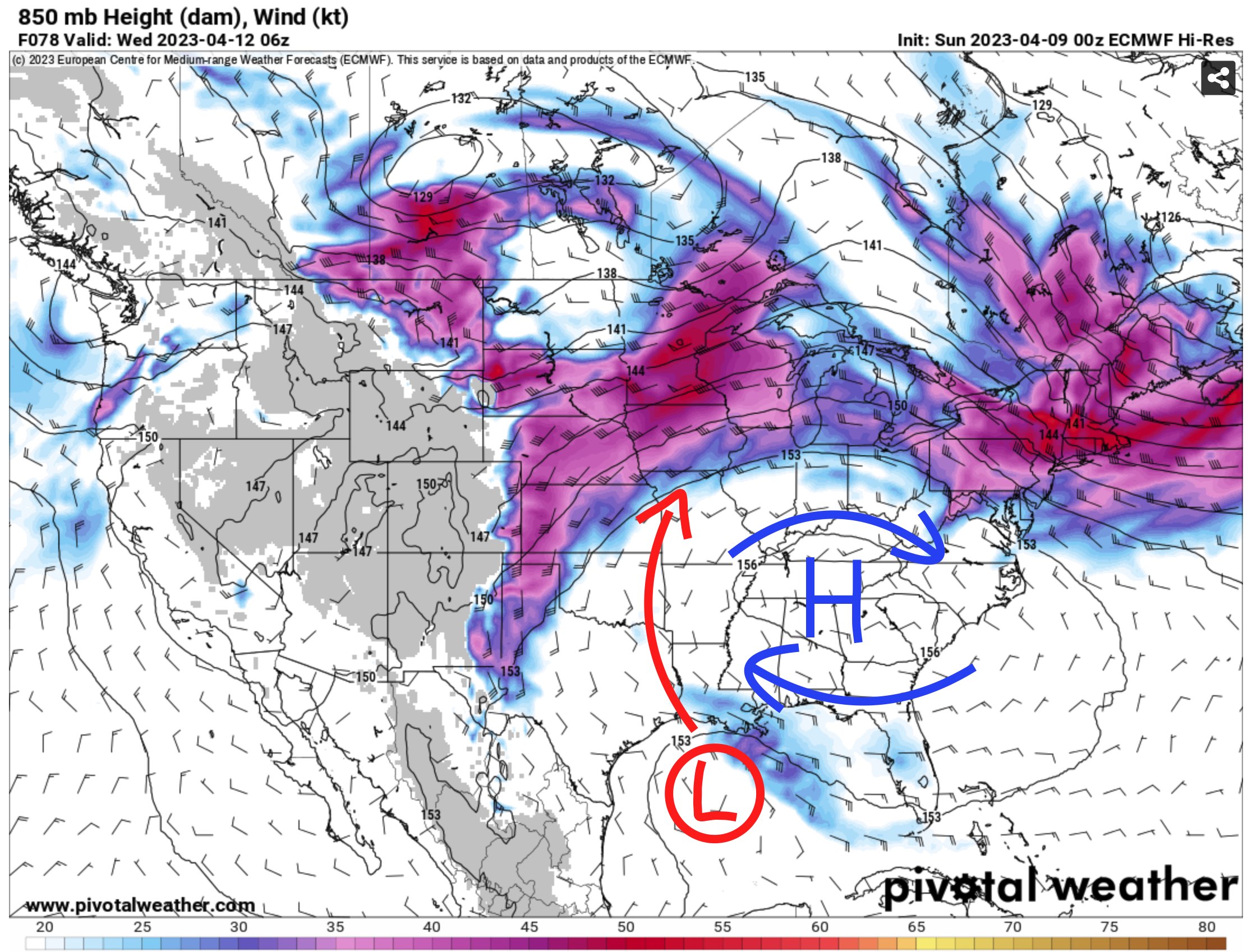
By late Tuesday night it will swing all the way around and end up off the coast of southwest Louisiana. It will get caught up in the now south-to-north flow on the backside of the ridge and ahead of the next storm system plowing our way from the west and get pulled inland.
Based on the latest data, where ever is gets pulled inland, between about Houston and New Orleans, will get some heavy rain and gusty wind. Not much worse that a typical general thunderstorm.
I went to find the most aggressive data I could calling for the worst-of-the-worst. And this is what I got


There is a good chance, if you watch any bigger weather news outlet they will say, “we will need to monitor this situation closely” which may make things sound a bit more dangerous than the situation probably warrants. I’m not trying to say this ‘thing’ is going to be as benign as a summer breeze, but keep in mind that all adverse weather can be dangerous. We just saw evidence of that at The Masters with a tree falling near a ton of people.
Too suggest that this upcoming situation is “worth monitoring” when, say, this last week wasn’t is probably misleading. For this situation, I don’t know that there is enough evidence in the model data nor in the real-time observations of water temperatures in the Gulf to suggest that this thing could do anything more than rain a lot and produce some gusty wind. Is that worth monitoring? Of course. Closely? Sure.
Monitored any differently than any other weather-related atmospheric situation? No.
In fact, this next weekend will probably offer a better chance for more impactful weather with passing showers and storms than whatever this thing may end up becoming. But that is a discussion for a later time, as we get closer with more meaningful data.
AG FORECAST
Here is a look at the Ag Forecast data for the next week:

For a full-size image: CLICK HERE
DAY TO DAY REGIONAL FORECAST
Today: Mostly cloudy with some extra sun this afternoon. Highs around 70. Northeast winds 10 to 15 mph.
Tonight: Mostly cloudy. Lows in the lower 50s. Northeast winds 10 to 15 mph.
Monday: Partly sunny. Highs in the upper 60s. Northeast winds around 10 mph.
Monday Night: Mostly cloudy. Lows in the lower 50s. Northeast winds 5 to 10 mph.
Tuesday: Partly sunny. Highs in the mid 70s. East winds 10 to 15 mph.
Tuesday Night: Mostly cloudy. Lows in the mid 50s.
Wednesday: Partly sunny with a 20 percent chance for a few showers. Highs in the upper 70s.
Wednesday Night: Mostly cloudy with a chance of showers with a slight chance of thunderstorms. Lows in the upper 50s. Chance of rain 40 percent.
Thursday: Mostly cloudy with storms possible. Highs in the mid 70s. Chance of rain 40 percent.
Thursday Night: Partly cloudy. Lows in the upper 50s.
Friday: Mostly sunny. Highs in the lower 80s.
Friday Night: Mostly clear in the evening, then becoming partly cloudy. Lows around 60.
Saturday: Mostly sunny. Highs in the mid 80s.


