Good morning folks, and happy Thursday!
There’s quite a lot going on across the country this morning, so let’s waste no time and jump right into the forecast!
Current Synoptic Picture

The main features to point out over the CONUS right now are the large ridge over Colorado, and the two upper-level lows with one approaching the Pacific Northwest Coast and the other in northern Quebec.
Northwestern United States
With the upper-level low having paralleled the coast earlier this week, it will continue to do so as it drifts northwestward away from the region.


However, it’s exit isn’t as straight forward as it seems in the images above. The upper-level low does back off slightly today, but as the system weakens by Saturday, it sends a pulse of abnormally low 850mb temperatures back into the region. So, while the temperatures will likely return to normal today and tomorrow across the Pacific Northwest, Saturday will serve as this upper-level low’s last hoorah with some cooler temperatures working their way into the region. By Sunday though, this feature has moved on, allowing temperatures to return back to normal.


All this translates to a region of below-average temperatures for the locations nearer the Pacific (especially for coastal Oregon and northern California), and some above-average temperatures for locations elsewhere across the Northwest.

With an upper-level low nearby, you’d still expect to see some rain across the region, right? Well, not quite… Even though this system is responsible for some synoptic-scale vertical motion, the relatively little moisture is hampering the development of widespread rain across the region, with the only legitimate chances for rain coming in the form of scattered orographically-enhanced showers on Sunday.
Southwestern United States
For the Southwest, the story is a little different, thanks in part to the Monsoon!
Thanks to the ridge in the center of the country imparting a southerly flow across the Southeast, moisture-rich air originating from the tropical Pacific and the Gulf of California has made a new home over parts of Arizona, New Mexico and southern Utah.
Not only are surface dewpoints well into the 50s and 60s, but precipitable water values are well over an inch. This, in addition to the heating at the surface will destabilize the atmosphere enough to produce afternoon showers and thunderstorms in a cycle that will repeat for several days.


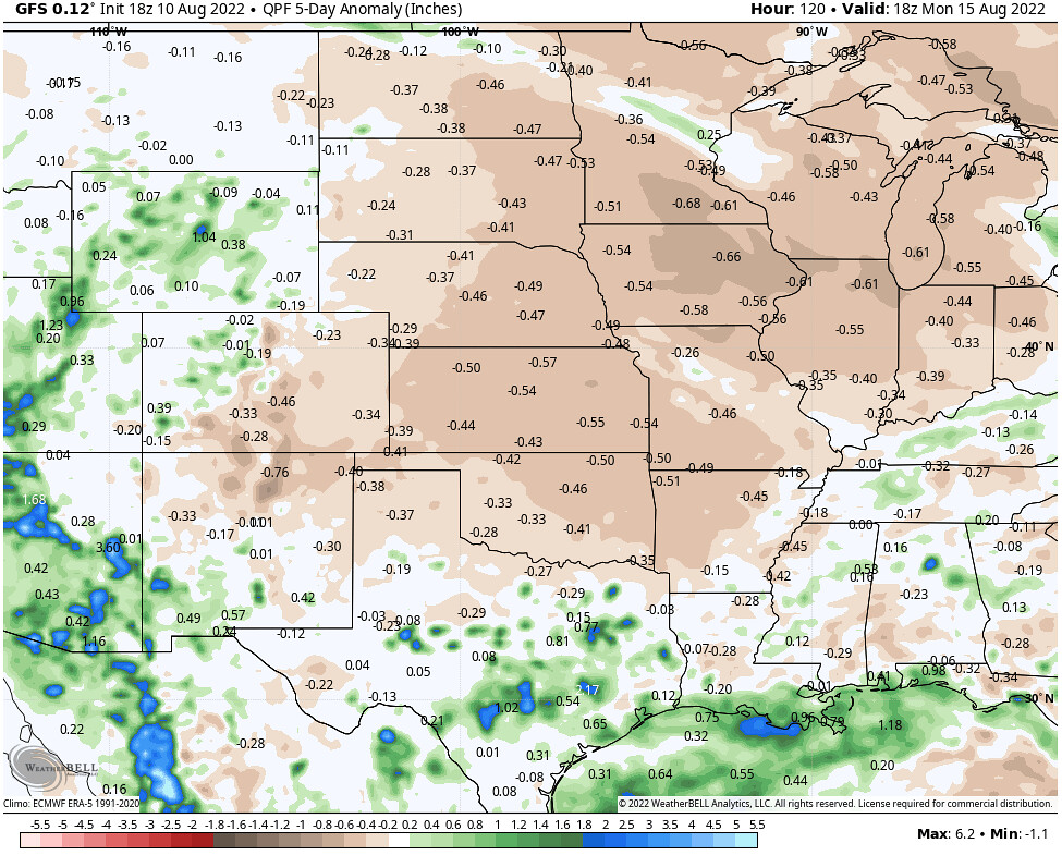
This moisture is even reaching as far north as parts of Idaho and Wyoming, resulting in an above-average 5-day rain forecast in the Southwest and parts of the Rockies.


All of the rain and clouds from these thunderstorms will help to keep the temperatures cooler for much of the Southeast, with the only exceptions being the locations missing out on these monsoon showers, such as southern California and western Nevada.

Central United States
As the ridge over the Central US continues to hang around and weaken slightly, we can expect some above-average temperatures and below-average precipitation underneath the ridge, which is true per the GFS…

One eye-popping feature from the images above is the bullseye of almost 15-degrees-above-average temperatures for parts of South Dakota, Nebraska and Kansas. This translates to temperatures exceeding 100F and approaching 110F in many locations in the Central Plains, with the one saving grace being relatively low dewpoints across the region. While these lower dewpoints won’t add to the heat index, apparent temperatures over 100F, which are expected across the Central Plains, are no laughing matter.
On the flip side, there is one part of the Central US that will be staying a bit cooler through the next dew days… southern Texas. As the upper-level ridge weakens, South Texas will be under an easterly flow regime, bringing in increased moisture from the Gulf of Mexico. In addition, more pockets of enhanced vorticity will be able to move into the region as they ride around the southern periphery of the ridge.

Northeastern United States
Thanks in part by the upper-level low that we identified in the beginning of our discussion, and the upper-level ridge over the Central US, the Northeast will experience surge of cooler, refreshing air. This will keep the temperatures on the cooler side, with widespread below-average temperatures expected over the next five days for the Northeast, the Mid-Atlantic and the parts of the Mid-West.

Southeastern United States
Even though the Southeast is in a similar pattern as the Northeast – being on the eastern side of a ridge and therefore experiencing northerly flow – the cooler air mass just wont make it all the way into the region. Instead, the boundary between the two air masses will be pushed into the Southeast and will continue to support an environment favorable for showers and thunderstorms, particularly in the afternoon when the instability is at its greatest.
According to the American GFS model, the coastal regions along the Gulf of Mexico and northern Florida will have the greatest chance for above-average rainfall through the next few days, with the rest of the region slightly below average.

So, in addition to the cooler air mass bringing temperatures down for Arkansas, Kentucky, Tennessee, the Carolinas and the northern halves of Mississippi, Alabama and Georgia, the enhanced rain and cloud cover will also keep temperatures slightly below average nearer to the Gulf Coast – resulting in pretty much the entire Southeast (or just the East in general) experiencing some cooler temperatures.

Long Range Outlook
Beyond the next few days, we can see this well-needed pattern shift is going to stick around for a bit. With the country less-dominated by the upper-level ridge, much of the eastern two thirds of the US will stay cooler, with only the North West forecast to be well-above average.


