Still looking at a cold few mornings across the area. Tomorrow and and Thursday morning temperatures willlikely bottom out around 35 for most folks with some people dipping to around freezing.
The NWS has issued Freeze Watches/Warnings for many places across the entire region. And in Mississippi, all the way down to the Gulf Coast.

That means it is a good night tonight to bring in any plants and don’t leave Fido or Spot to sleep outside, if possible, either. If you see the freezing mark, it should be pretty brief. An hour or two, at most. But that would be enough time to really hurt any warm-loving plants and leave any pets rather cold.
Temperatures will drop to around 35F across the area according to model guidance.


Most of the cold we will experience overnight will have to do with radiating all the heat out into the atmosphere. That also means the temperatures ont eh maps above are probably juuuust a hair too warm.
But, because we aren’t exactly plowing any really cold air into the area during the day today, we don’t ahve ot worry about a big change in temps overnight compared to last night where this air was- does that make sense? Looking at the reverse air trajectories, the air we will ‘walk out the door to’ tomorrow morning will be the same air that is hanging around near Memphis and Tupelo this morning.

Temperatures this morning up there are between about 33F and 38F. Forecasts from the NWS up there called for temperatures between 30F and 34F. So the cold slightly under-performed relative to model data.
So we will have to see how things shake out down here.
A few folks have asked, “Well if it is this cold now, does this mean a really cold Winter?”
The short answer is “not really” and the longer answer is complicated. But probably boils down to “not really” also.
Looking at data going back to 1948, the mathematical correlation between cooler October’s and cooler Winter’s is a – very low – 0.25, And if we ask what about just the coldest winters, it is even lower, at 0.25.
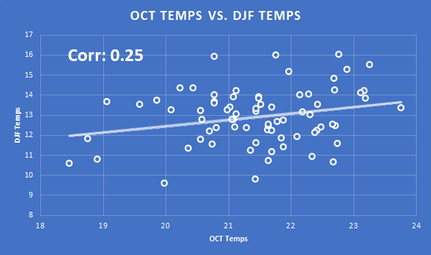

So, it is safe to say, there isn’t a good relationship between cooler October’s and cooler Winter’s.
Today
Sunny. Much cooler with highs around 60. North winds 10 to 15 mph.
Tonight
Clear. Patchy frost after midnight. Cooler with lows in the lower 30s. North winds 5 to 10 mph.
Wednesday
Areas of frost in the morning. Sunny. Highs in the lower 60s. North winds around 5 mph.
Wednesday Night
Clear. Areas of frost after midnight. Lows in the lower 30s. Northwest winds around 5 mph.
Thursday
Areas of frost in the morning. Sunny. Highs in the upper 60s. West winds around 5 mph.
Thursday Night
Clear. Lows around 40.
Friday
Sunny. Not as cool with highs in the upper 70s.
Friday Night
Clear. Not as cool with lows in the lower 50s.
Saturday
Sunny. Highs around 80.
Saturday Night
Mostly clear. Lows in the lower 50s.
Sunday
Sunny. Highs in the lower 80s.
Sunday Night
Mostly clear in the evening, then becoming partly cloudy. Lows in the mid 50s.
Monday
Mostly sunny. Highs in the lower 80s.


