The cooler air is still headed this way. Imported from Canada! The air from the Beaufort Sea the other day is already hanging out near Winnipeg.

The cooler air is helping to drop snow across parts of Wisconsin and Minnesota, too.
That same air will plow south, descending from up around 3000ft down to the surface (warming). and it will be modified along the way, too (warming). So we don’t have to worry about snow, but we do have to worry about a frost. A freeze for this far south seems a bit too much right now, but north of I-20 it’ll be close.
You can see all the blue ont eh maps showing how much cooler than normal it will be.


The record for earliest freeze, depending on the weather station, south of I-20 is between October 15th and October 25th, so if it does happens, it could be record-setting.
Outside of the cold, there is a background risk for storms as we head past next weekend, but before then it’ll be chilly and dry!
If you’re wondering, “What does cold like this mean for winter?!?”
Almost nothing.
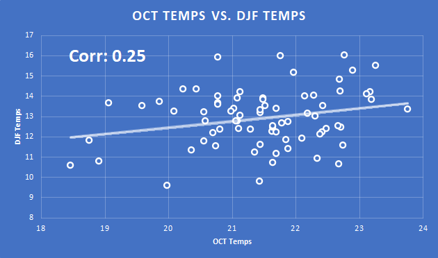
It turns out that the correlation is just 0.25 when looking back at records to 1948 comparing October temperatures to DJF temperatures.
So, rest easy. This isn’t much of an indicator that this winter will be any different than any other winter. There may be other factors at play, but an early chance at a frost isn’t one of them.
DAY TO DAY FORECAST
Today
Patchy fog this morning. Partly sunny. Highs in the upper 70s.
Tonight
Partly cloudy in the evening, then clearing. Much cooler. Less humid with lows in the mid 40s.
Tuesday
Sunny and breezy. Much cooler with highs in the mid 60s. North winds 10 to 15mph with gusts up to 25 mph.
Tuesday Night
Clear, colder with lows around 35. Wind still gusting to 15mph will drop wind chill into the upper 20s at times.
Wednesday
Sunny. Highs in the lower 60s.
Wednesday Night
Clear, cold with lows around 35.
Thursday
Sunny. Highs in the upper 60s.
Thursday Night
Clear. Lows in the upper 30s.
Friday
Sunny. Highs in the mid 70s.
Friday Night
Clear. Not as cool with lows in the upper 40s.
Saturday
Sunny. Highs around 80.
Saturday Night
Mostly clear. Lows in the lower 50s.
Sunday
Sunny. Highs around 80.


