Good morning and happy Friday everyone! In today’s forecast, we will be continuing to monitor the rainfall potential and the temperature outlook over the next week.
As has been mentioned in both the tropical updates and local forecasts from other interns, the NHC is no-longer concerned about the area of low pressure forming in the Gulf, which is good news as no effects will be felt in terms of wind from a tropical system. However, our area will still see rain over the next week, mainly from convective day-time heating type showers and thunderstorms.
Firstly, we will begin with a look at the upper-level synoptic or large scale pattern, to get a sense of where we are weather wise.

Currently, there is broad ridge centered just to the west of Texas (center marked by blue H) and a trough currently over the east coast and into the southeast (red dashed lines). This is giving the region generally north to northeasterly flow, leading to very dry mid-levels.
What this means, is that since the ridge is not centered directly over us, the region should experience typical day-time summer thunderstorm activity, along with more seasonable to slightly cooler temperatures in the upper 80s and around 90.
Taking a more detailed look at today, the aforementioned ridge to our north and west and chances for convection each day will limit high temperatures right around 90.

Precipitation wise for today, with the frontal passage experienced yesterday now to our south and east, day-time heating will be the main driver for storms rather than frontal precip, leading to more scattered chances for rain. Storms should begin to fire off around 1-2PM central time, with threats diminishing as the sun beings to set. Any storms tomorrow aren’t expected to be severe, but as always there is potential for lightning and urban flooding in poor drainage areas.

Moving into the weekend, and into the beginning of the next work week, northerly flow will continue over the region as well as a trough moving past us to our north.

This means for the beginning half of the week, typical southeast summer conditions will prevail, with the message mainly being convective type showers and along with temperatures either side and close to 90. Our highest chances for rain after today are to be on Monday, where a trough will be moving through just to our north into our forecast area.

The red dashed line on the map indicates the trough axis, and increased troughing over the area will allow for falling heights to assist with greater rainfall potential.
As we progress later into the week (Wednesday into Thursday), the chances to see slightly higher temperatures increases as the ridge to our west continues to build and move slightly closer into our forecast area. Combined with the increasing humidity, heat indices will likely rise and stray closer to 105.
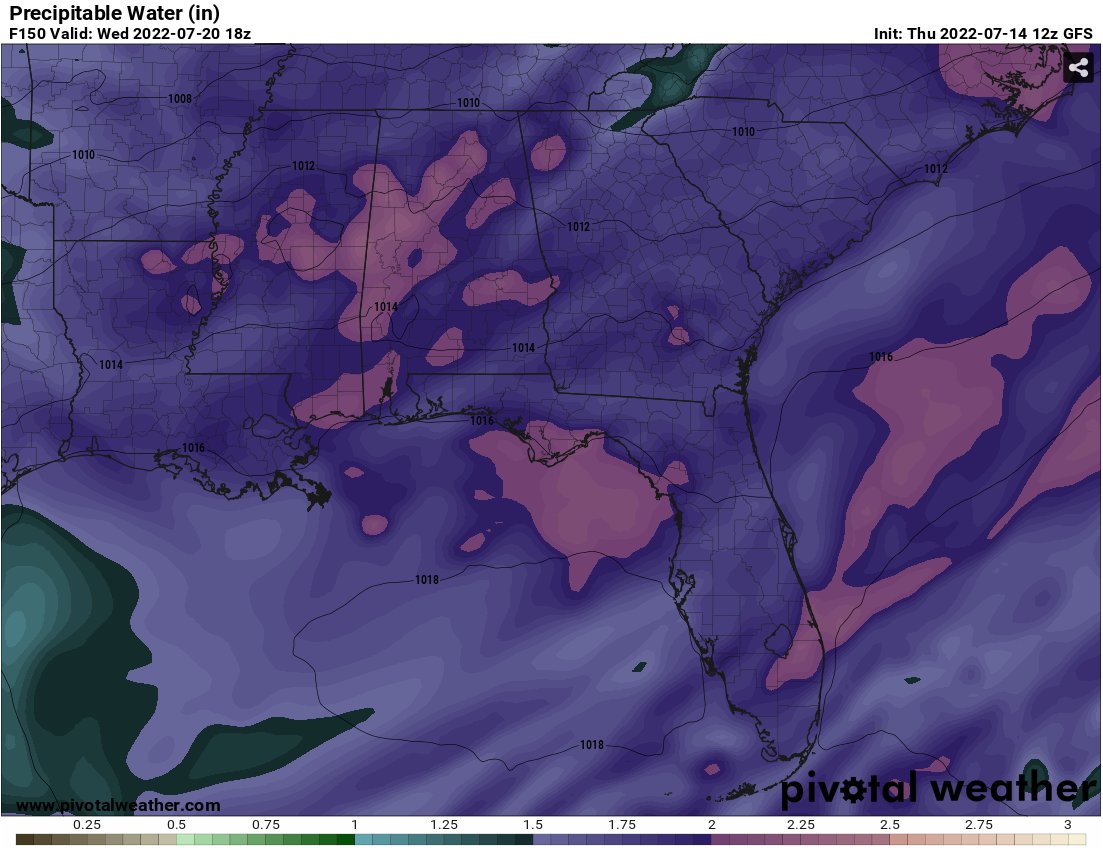
With precipitable water values closer to 2″ by Wednesday, the rising humidity and temperatures near and or slightly above 90 will lead to heat indices inching closer to 105.
Besides the chance for a slight warmup towards the end of the week, the current forecast is not too busy with the main concerns being potential shower and thunderstorm activity!
(adsbygoogle = window.adsbygoogle || []).push({});
Day to Day Forecast
Today
Mix of sun and clouds with a 40-percent chance of afternoon showers and thunderstorms. High’s in the low 90s. Wind east at 5mph.
Tonight
Partly cloudy with a 30-percent chance of showers and thunderstorms. Lows in the low 70s. Wind calm.
Saturday
Mostly sunny with a 30-percent chance of showers and thunderstorms. High’s in the low 90s. Wind east at 5mph.
Saturday Night
Clear with lows in the low 70s. Wind calm.
Sunday
Mostly sunny with a 40-percent chance of showers and thunderstorms. High’s in the low 90s. Wind southeast at 5-to-10mph.
Sunday Night
Partly cloudy with lows in the low 70s. Wind calm.
Monday
Mix of sun and clouds with a 60-percent chance of afternoon showers and thunderstorms. Highs in the low 90s. Wind southwest at 5mph.
Monday Night
Partly cloudy with lows in the low 70s. Wind southwest at 5mph.
Tuesday
Mostly sunny with a 20-percent chance of afternoon showers and thunderstorms. Highs in the low 90s. Wind southwest at 5mph.
Tuesday Night
Partly cloudy with lows in the mid 70s. Wind calm.
Wednesday
Mostly sunny with a 20-percent chance showers and thunderstorms. Highs in the low 90s.
Wednesday Night
20-percent chance of showers and thunderstorms. Partly cloudy with lows in the mid 70s.
Thursday
Partly cloudy with a 20-percent chance of showers and thunderstorms. Highs in the mid 90s.
Thursday Night
Partly cloudy with a 30-percent chance of showers and thunderstorms. Lows in the mid 70s.


Don’t really see where you’re getting such high rain chances, especially with this weekend and the Tuesday through Thursday period. Might wanta look at what Tidbits is showing and compare.